State of Environment Report 2007-08 - Wollongong City Council
State of Environment Report 2007-08 - Wollongong City Council
State of Environment Report 2007-08 - Wollongong City Council
Create successful ePaper yourself
Turn your PDF publications into a flip-book with our unique Google optimized e-Paper software.
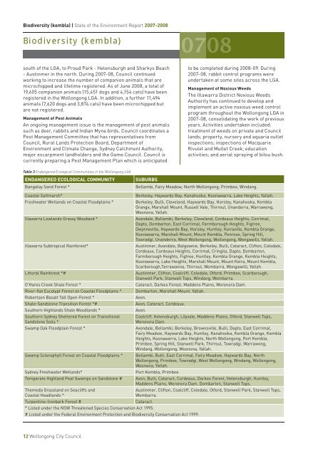
Biodiversity (kembla) | <strong>State</strong> <strong>of</strong> the <strong>Environment</strong> <strong>Report</strong> <strong>2007</strong>-20<strong>08</strong>Biodiversity (kembla)south <strong>of</strong> the LGA, to Proud Park - Helensburgh and Sharkys Beach- Austinmer in the north. During <strong>2007</strong>-<strong>08</strong>, <strong>Council</strong> continuedworking to increase the number <strong>of</strong> companion animals that aremicrochipped and lifetime registered. As <strong>of</strong> June 20<strong>08</strong>, a total <strong>of</strong>19,605 companion animals (15,451 dogs and 4,154 cats) have beenregistered in the <strong>Wollongong</strong> LGA. In addition, a further 11,494animals (7,620 dogs and 3,874 cats) have been microchipped butare not registered.Management <strong>of</strong> Pest AnimalsAn ongoing management issue is the management <strong>of</strong> pest animalssuch as deer, rabbits and Indian Myna birds. <strong>Council</strong> coordinates aPest Management Committee that has representatives from<strong>Council</strong>, Rural Lands Protection Board, Department <strong>of</strong><strong>Environment</strong> and Climate Change, Sydney Catchment Authority,major escarpment landholders and the Game <strong>Council</strong>. <strong>Council</strong> iscurrently preparing a Pest Management Plan which is anticipatedto be completed during 20<strong>08</strong>-09. During<strong>2007</strong>-<strong>08</strong>, rabbit control programs wereundertaken at some sites across the LGA.Management <strong>of</strong> Noxious WeedsThe Illawarra District Noxious WeedsAuthority has continued to develop andimplement an active noxious weed controlprogram throughout the <strong>Wollongong</strong> LGA in<strong>2007</strong>-<strong>08</strong>, consolidating the work <strong>of</strong> previousyears. Activities undertaken included:treatment <strong>of</strong> weeds on private and <strong>Council</strong>lands; property, nursery and aquaria outletinspections; inspections <strong>of</strong> MacquarieRivulet and Mullet Creek; educationactivities; and aerial spraying <strong>of</strong> bitou bush.Table 3 Endangered Ecological Communities in the <strong>Wollongong</strong> LGAENDANGERED ECOLOGICAL COMMUNITYBangalay Sand Forest *SUBURBSBellambi, Fairy Meadow, North <strong>Wollongong</strong>, Primbee, Windang.Coastal Saltmarsh*Freshwater Wetlands on Coastal Floodplains *Illawarra Lowlands Grassy Woodand *Illawarra Subtropical Rainforest*Littoral Rainforest *#O’Hares Creek Shale Forest *River-flat Eucalypt Forest on Coastal Floodplains *Robertson Basalt Tall Open-Forest *Shale-Sandstone Transition Forest *#Southern Highlands Shale Woodlands *Southern Sydney Sheltered Forest on TransitionalSandstone Soils *Swamp Oak Floodplain Forest *Swamp Sclerophyll Forest on Coastal Floodplains *Sydney Freshwater Wetlands*Temperate Highland Peat Swamps on Sandstone #Themeda Grassland on Seacliffs andCoastal Headlands *Turpentine-Ironbark Forest #Berkeley, Haywards Bay, Kanahooka, Koonawarra, Lake Heights, Yallah.Berkeley, Bulli, Cleveland, Haywards Bay, Horsley, Kanahooka, KemblaGrange, Marshall Mount, Russell Vale, Thirroul, Unanderra, Warrawong,Woonona, Yallah.Avondale, Bellambi, Berkeley, Cleveland, Cordeaux Heights, Corrimal,Dapto, Dombarton, East Corrimal, Farmborough Heights, Figtree,Gwynneville, Haywards Bay, Horsley, Huntley, Keiraville, Kembla Grange,Koonawarra, Marshall Mount, Mount Kembla, Penrose, Spring Hill,Towradgi, Unanderra, West <strong>Wollongong</strong>, <strong>Wollongong</strong>, Wongawilli, Yallah.Austinmer, Avondale, Balgownie, Berkeley, Bulli, Cataract, Clifton, Coledale,Cordeaux, Cordeaux Heights, Corrimal, Cringila, Dapto, Dombarton,Farmborough Heights, Figtree, Huntley, Kembla Grange, Kembla Heights,Koonawarra, Lake Heights, Marshall Mount, Mount Keira, Mount Kembla,Scarborough,Tarrawanna, Thirroul, Wombarra, Wongawilli, Yallah.Austinmer, Clifton, Coalcliff, Coledale, Otford, Primbee, Scarborough,Stanwell Park, Stanwell Tops, Windang, Wombarra.Cataract, Darkes Forest, Maddens Plains, Woronora Dam.Dombarton, Marshall Mount, Yallah.Avon.Avon, Cataract, Cordeaux.Avon.* Listed under the NSW Threatened Species Conservation Act 1995.# Listed under the Federal <strong>Environment</strong> Protection and Biodiversity Conservation Act 1999.Coalcliff, Helensburgh, Lilyvale, Maddens Plains, Otford, Stanwell Tops,Woronora Dam.Avondale, Bellambi, Berkeley, Brownsville, Bulli, Dapto, East Corrimal,Fairy Meadow, Haywards Bay, Huntley, Kanahooka, Kembla Grange, KemblaHeights, Koonawarra, Lake Heights, North <strong>Wollongong</strong>, Port Kembla,Primbee, Spring Hill, Stanwell Park, Thirroul, Towradgi, Warrawong,Windang, <strong>Wollongong</strong>, Woonona, Yallah.Bellambi, Bulli, East Corrimal, Fairy Meadow, Haywards Bay, North<strong>Wollongong</strong>, Primbee, Towradgi, West <strong>Wollongong</strong>, Windang, <strong>Wollongong</strong>,Woonona, Yallah.Port Kembla, Primbee.Avon, Bulli, Cataract, Cordeaux, Darkes Forest, Helensburgh, Huntley,Maddens Plains, Woronora Dam, Dombarton, Stanwell Tops.Austinmer, Clifton, Coalcliff, Coledale, Otford, Stanwell Park, Stanwell Tops,Wombarra.Cataract.12 <strong>Wollongong</strong> <strong>City</strong> <strong>Council</strong>


