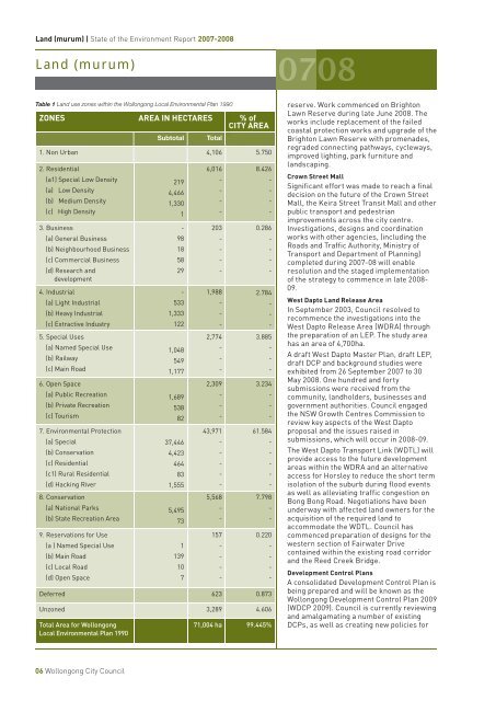
Land (murum) | <strong>State</strong> <strong>of</strong> the <strong>Environment</strong> <strong>Report</strong> <strong>2007</strong>-20<strong>08</strong>Land (murum)Table 1 Land use zones within the <strong>Wollongong</strong> Local <strong>Environment</strong>al Plan 1990ZONES AREA IN HECTARES % <strong>of</strong>CITY AREASubtotalTotal1. Non Urban 4,106 5.7502. Residential(a1) Special Low Density(a) Low Density(b) Medium Density(c) High Density3. Business(a) General Business(b) Neighbourhood Business(c) Commercial Business(d) Research anddevelopment4. Industrial(a) Light Industrial(b) Heavy Industrial(c) Extractive Industry5. Special Uses(a) Named Special Use(b) Railway(c) Main Road6. Open Space(a) Public Recreation(b) Private Recreation(c) Tourism7. <strong>Environment</strong>al Protection(a) Special(b) Conservation(c) Residential(c1) Rural Residential(d) Hacking River8. Conservation(a) National Parks(b) <strong>State</strong> Recreation Area9. Reservations for Use(a ) Named Special Use(b) Main Road(c) Local Road(d) Open Space2194,4661,3301-98185829-5331,3331221,0485491,1771,6895388237,4464,423464831,5555,4957311391076,016----203----1,988---2,774---2,309---43,971-----5,568--157----8.426----0.286----2.784---3.885---3.234---61.584-----7.798--0.220----Deferred 623 0.873Unzoned 3,289 4.606Total Area for <strong>Wollongong</strong>Local <strong>Environment</strong>al Plan 199071,004 ha 99.445%reserve. Work commenced on BrightonLawn Reserve during late June 20<strong>08</strong>. Theworks include replacement <strong>of</strong> the failedcoastal protection works and upgrade <strong>of</strong> theBrighton Lawn Reserve with promenades,regraded connecting pathways, cycleways,improved lighting, park furniture andlandscaping.Crown Street MallSignificant effort was made to reach a finaldecision on the future <strong>of</strong> the Crown StreetMall, the Keira Street Transit Mall and otherpublic transport and pedestrianimprovements across the city centre.Investigations, designs and coordinationworks with other agencies, (including theRoads and Traffic Authority, Ministry <strong>of</strong>Transport and Department <strong>of</strong> Planning)completed during <strong>2007</strong>-<strong>08</strong> will enableresolution and the staged implementation<strong>of</strong> the strategy to commence in late 20<strong>08</strong>-09.West Dapto Land Release AreaIn September 2003, <strong>Council</strong> resolved torecommence the investigations into theWest Dapto Release Area (WDRA) throughthe preparation <strong>of</strong> an LEP. The study areahas an area <strong>of</strong> 4,700ha.A draft West Dapto Master Plan, draft LEP,draft DCP and background studies wereexhibited from 26 September <strong>2007</strong> to 30May 20<strong>08</strong>. One hundred and fortysubmissions were received from thecommunity, landholders, businesses andgovernment authorities. <strong>Council</strong> engagedthe NSW Growth Centres Commission toreview key aspects <strong>of</strong> the West Daptoproposal and the issues raised insubmissions, which will occur in 20<strong>08</strong>-09.The West Dapto Transport Link (WDTL) willprovide access to the future developmentareas within the WDRA and an alternativeaccess for Horsley to reduce the short termisolation <strong>of</strong> the suburb during flood eventsas well as alleviating traffic congestion onBong Bong Road. Negotiations have beenunderway with affected land owners for theacquisition <strong>of</strong> the required land toaccommodate the WDTL. <strong>Council</strong> hascommenced preparation <strong>of</strong> designs for thewestern section <strong>of</strong> Fairwater Drivecontained within the existing road corridorand the Reed Creek Bridge.Development Control PlansA consolidated Development Control Plan isbeing prepared and will be known as the<strong>Wollongong</strong> Development Control Plan 2009(WDCP 2009). <strong>Council</strong> is currently reviewingand amalgamating a number <strong>of</strong> existingDCPs, as well as creating new policies for06 <strong>Wollongong</strong> <strong>City</strong> <strong>Council</strong>
Land (murum) | <strong>State</strong> <strong>of</strong> the <strong>Environment</strong> <strong>Report</strong> <strong>2007</strong>-20<strong>08</strong>Land (murum)inclusion into the WDCP 2009, withcompletion anticipated for the end <strong>of</strong> thenext financial year.Illawarra EscarpmentOne <strong>of</strong> the recommendations <strong>of</strong> theIllawarra Escarpment Commission <strong>of</strong>Inquiry was the preparation <strong>of</strong> anIllawarra Escarpment StrategicManagement Plan (IESMP). FollowingMinisterial endorsement in 2006, <strong>Council</strong>engaged consultants to prepare a review<strong>of</strong> land use in the escarpment.The Illawarra Escarpment Land UseReview Strategy (IELURS) examined landuse on the escarpment in accordance withsustainability objectives defined in theIESMP. The IELURS was informed by anIndigenous and non-Indigenous HeritageStudy and a Visual Quality Analysis. TheIELURS, along with its recommendedamendments to the draft <strong>Wollongong</strong> LEP<strong>2007</strong>, was presented to <strong>Council</strong> forendorsement in August <strong>2007</strong>. The draft<strong>Wollongong</strong> Development Control Plan2009 was also amended based on therecommendations arising from theIELURS.<strong>Council</strong> is working with state governmentagencies on the implementation <strong>of</strong> theIESMP through a working group consisting<strong>of</strong> members from the Department <strong>of</strong>Climate Change, Southern RiversCatchment Management Authority and theDepartment <strong>of</strong> Lands. The objectives <strong>of</strong>the group include the attraction andadministration <strong>of</strong> funds for implementingon-ground works on the IllawarraEscarpment. <strong>Council</strong> is currentlydeveloping a Vertebrate Pest ManagementPolicy to help guide the management <strong>of</strong>vertebrate pests on the IllawarraEscarpment and coastal plain.Community LandUnder the Local Government Act 1993,<strong>Council</strong> is required to categorise allcommunity land into five categories: park,sportsground, general community use,cultural significance and natural areas.There are 538 sites categorised as naturalareas, which are further divided into anadditional five sub-categories: bushland,wetland, escarpment, foreshore andwatercourse. <strong>Council</strong> has approximately784 sites <strong>of</strong> community land, coveringapproximately 2,350ha. These sites <strong>of</strong>community land include <strong>Council</strong> ownedand managed land. <strong>Council</strong> also manages174 areas <strong>of</strong> Crown Reserves.In accordance with the requirements <strong>of</strong>the Local Government Act 1993, theGeneric Plan <strong>of</strong> Management for theCommunity Land <strong>of</strong> <strong>Wollongong</strong> <strong>City</strong> <strong>Council</strong> was adopted in March<strong>2007</strong>. This includes land categorised as park, sportsground,general community use and natural areas, unless they are coveredunder a site specific plan <strong>of</strong> management. This generic plan coversover 95% <strong>of</strong> <strong>Council</strong>’s community land.Site specific plans <strong>of</strong> management are required for approximately5% <strong>of</strong> community land across the <strong>Wollongong</strong> LGA. To date, <strong>Council</strong>has adopted the following site specific plans <strong>of</strong> management:<strong>Wollongong</strong> <strong>City</strong> Foreshore - covering Stuart Park, North Beach,<strong>City</strong> Beach, Osborne Park, Belmore Basin and Lang Park; BeatonPark; Bald Hill; Andrew Lysaght Park; <strong>Wollongong</strong> Botanic Garden- including Gleniffer Brae; Judbooley Parade, Windang; andColedale Beach Reserve. Site specific plans <strong>of</strong> management arebeing prepared for Stanwell Park and Sublime Point.Floodplain Management Plans<strong>Council</strong> is preparing floodplain management plans for all majorcatchments in the <strong>Wollongong</strong> LGA. Each plan will assess floodimpacts on the floodplain and creek environments, as well asidentify structural and non-structural flood mitigation measures tominimise these impacts. <strong>Council</strong> has completed a Plan forTowradgi, Minnegang, Allans and Hewitts creeks (incorporatingSlacky, Tramway, Woodlands and Thomas Gibson creeks). Workcarried out to implement these plans has included: one voluntarypurchase <strong>of</strong> a property in the Allans Creek catchment; twovoluntary purchases <strong>of</strong> properties in the Fairy Creek catchment;investigation <strong>of</strong> upgrading the culverts at Tramway and Woodlandscreeks, upgrading the culvert under the northern distributor atCorrimal; and upgrading the spillway at the detention basin atBarina Park, Minnegang Creek. Preparation <strong>of</strong> the Cabbage Tree/Fairy Creek, Mullet Creek and Lake Illawarra FloodplainManagement plans are also underway.Table 2 Land use zones within the <strong>Wollongong</strong> <strong>City</strong> Centre Local <strong>Environment</strong>al Plan <strong>2007</strong>ZONESAREA INHECTARES% <strong>of</strong> CITYAREATotalR1 General residential 127 0.178B3 Commercial core 62 0.<strong>08</strong>7B4 Mixed use 41 0.057B6 Enterprise corridor 29 0.041IN4 Working waterfront 3 0.004SP1 Special activities - hospitals and19 0.027medical research and developmentSP2 Infrastructure 20 0.028SP3 Tourist 7 0.010RE1 Public recreation 73 0.102RE2 Private recreation 15 0.021Total Area for <strong>Wollongong</strong> <strong>City</strong> CentreLocal <strong>Environment</strong>al Plan <strong>2007</strong>396 ha 0.555%Grand Total for <strong>Wollongong</strong> LocalGovernment Area71,400 ha 100%<strong>Wollongong</strong> <strong>City</strong> <strong>Council</strong> 07