divisi<strong>on</strong>. The coastline is broken at pointsby bald-headed hills. While the altitude inthe plains divisi<strong>on</strong> is about 75 m that <str<strong>on</strong>g>of</str<strong>on</strong>g> thehills extends to an average <str<strong>on</strong>g>of</str<strong>on</strong>g> 900 m withthe highest altitude being 1,615 m. In terms<str<strong>on</strong>g>of</str<strong>on</strong>g> climatic c<strong>on</strong>diti<strong>on</strong>s, while the coastalregi<strong>on</strong>s have a warm climate, as <strong>on</strong>e movestowards the hilly areas the temperaturelowers as a result <str<strong>on</strong>g>of</str<strong>on</strong>g> the altitude andvegetati<strong>on</strong>. The annual rainfall that thedistrict receives is 1,202 mm, primarilyfrom the southwest m<strong>on</strong>so<strong>on</strong> that accountsfor more than 70 percent <str<strong>on</strong>g>of</str<strong>on</strong>g> the rainfall. Thenortheast m<strong>on</strong>so<strong>on</strong>, and the summer andwinter showers c<strong>on</strong>tribute the rest. TheAgency and inland areas receive rainfallfrom the southwest m<strong>on</strong>so<strong>on</strong> while thecoastal regi<strong>on</strong>s are more favoured by thenortheast m<strong>on</strong>so<strong>on</strong>. The district lies in theriver basin <str<strong>on</strong>g>of</str<strong>on</strong>g> the Thandava, Varaha, Saradaand Gosthani rivers and the larger rivuletsflowing through it include Meghadrigeddaand Ghambheeragedda.The geographical area <str<strong>on</strong>g>of</str<strong>on</strong>g> the district is11,161 sq km which is 4.1 percent <str<strong>on</strong>g>of</str<strong>on</strong>g> thearea <str<strong>on</strong>g>of</str<strong>on</strong>g> the entire state. Of this <strong>on</strong>ly 36.45percent is arable land. Of the arable area, thenet area sowed forms 27.2 percent whilecultivable waste and fallow (current andold) lands c<strong>on</strong>stitute about 9.2 percent(during 2006-07). More than <strong>on</strong>e-third <str<strong>on</strong>g>of</str<strong>on</strong>g>the land i.e., 39.53 percent is covered byforests. The remaining is distributedbetween ‘barren and uncultivable land’ 11.7percent and 9 percent is ‘land put to n<strong>on</strong>agriculturaluse’. Administratively thedistrict is divided into three revenuedivisi<strong>on</strong>s and 43 mandals.The populati<strong>on</strong> <str<strong>on</strong>g>of</str<strong>on</strong>g> the district is 38.32 lakhsas per the 2001 Census and this c<strong>on</strong>stitutes 5percent <str<strong>on</strong>g>of</str<strong>on</strong>g> the populati<strong>on</strong> <str<strong>on</strong>g>of</str<strong>on</strong>g> the state. Thedistrict has a populati<strong>on</strong> density <str<strong>on</strong>g>of</str<strong>on</strong>g> 343 perpers<strong>on</strong>s per sq km; however, the Agencyarea has a lower density than the plain areas.Fifteen adivasi communities reside in theFifth Schedule area <str<strong>on</strong>g>of</str<strong>on</strong>g> Visakhapatnamdistrict and include the Bagata, Gadaba,Goudu, Kammara, K<strong>on</strong>da Dora, Kh<strong>on</strong>ds,Kotia, Kulia/Mulias, Mali, Manne Dora,Mukha Dora, Porja, Reddi Dora/NookaDora/Mukha Dora, R<strong>on</strong>a/Rena/Rana andValmiki communities. They comprise 14.55percent <str<strong>on</strong>g>of</str<strong>on</strong>g> the entire districts populati<strong>on</strong>(Box 3: ST populati<strong>on</strong> indicators forVisakhapatnam district). These tribalpopulati<strong>on</strong>s live in hill-top villages orhamlets, many <str<strong>on</strong>g>of</str<strong>on</strong>g> which are very remote anddifficult to access.The case study discussed is <str<strong>on</strong>g>of</str<strong>on</strong>g> two adivasicommunities, the Nooka Dora and K<strong>on</strong>daDora tribal groups, residing in the villages<str<strong>on</strong>g>of</str<strong>on</strong>g> Beespuram and Nimmalpadu inAnanthagiri mandal <str<strong>on</strong>g>of</str<strong>on</strong>g> Visakhapatnamdistrict. The Nooka Dora numbers 29,680while the K<strong>on</strong>da Doras are a populati<strong>on</strong> <str<strong>on</strong>g>of</str<strong>on</strong>g>179,334 (figures as per the 1991 Census).The case study looks at the livelihoods, foodsecurity, and income and expenditurepatterns <str<strong>on</strong>g>of</str<strong>on</strong>g> these tribal people. A total <str<strong>on</strong>g>of</str<strong>on</strong>g> 39pers<strong>on</strong>al interviews using a questi<strong>on</strong>nairewere c<strong>on</strong>ducted in two villages—20 fromBeespuram and 19 from Nimmalpadu—toBox 3: ST populati<strong>on</strong> indicators for Visakhapatnam districtST populati<strong>on</strong>-Total: 557,572ST populati<strong>on</strong>-Male: 278,399ST populati<strong>on</strong>-Female: 279,173Percentage share <str<strong>on</strong>g>of</str<strong>on</strong>g> ST populati<strong>on</strong> to district populati<strong>on</strong>: 14.55 percentPercentage to total states ST populati<strong>on</strong>: 11.1 percentSource: Census 2001 and Fact Book <strong>on</strong> Scheduled Castes and Scheduled Tribes in Andhra Pradesh.Directorate <str<strong>on</strong>g>of</str<strong>on</strong>g> Ec<strong>on</strong>omics and Statistics, Hyderabad, Andhra Pradesh, India.3030
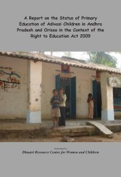
collect the required data. The Nimmalpaduvillage comprises smaller hamlets and theinterviews were c<strong>on</strong>ducted in the hamlets <str<strong>on</strong>g>of</str<strong>on</strong>g>Karakavalasa and Rallavalasa.Village and household informati<strong>on</strong>Beespuram is a village <str<strong>on</strong>g>of</str<strong>on</strong>g> 45 households anda populati<strong>on</strong> numbering 197 (men: 74,women: 72, children: 51). The adivasishere are from the Nooka Dora community.There are 10 pucca and 35 kaccha houses inthe village. The pucca houses are madefrom cement with slabs as ro<str<strong>on</strong>g>of</str<strong>on</strong>g>s while thekaccha houses are mud structures with tiledor grass ro<str<strong>on</strong>g>of</str<strong>on</strong>g>ing. The village is located <strong>on</strong>the roadside and is accessible by a c<strong>on</strong>creteroad in all weathers. The main water sourcefor the village is a stream and a small lake.The village has electricity c<strong>on</strong>necti<strong>on</strong>, ananganwadi and a primary school. The mainhealth problems faced by the village aremalaria, jaundice and diarrhoea. The nearestPHC is located in Ananthagiri about 10 kmfrom the village. Ananthagiri is the mandalheadquarters and has a Veterinary Hospital,Forest Department and AgricultureDepartment Office as well. The local marketor shandy (known locally as santha) forgrains, NTFP and vegetables is also locatedin Ananthagiri. The nearest Reserve Forestis located at Ananthagiri while thecommunity forest accessed by the residentsis situated close to the village itself. Thevillage is located at the foothills <str<strong>on</strong>g>of</str<strong>on</strong>g>Galik<strong>on</strong>da, <strong>on</strong>e <str<strong>on</strong>g>of</str<strong>on</strong>g> the proposed bauxiteextracti<strong>on</strong> sites.The hamlets <str<strong>on</strong>g>of</str<strong>on</strong>g> Karakavalasa andRallavalasa c<strong>on</strong>stitute a part <str<strong>on</strong>g>of</str<strong>on</strong>g> theNimmalpadu village. The total populati<strong>on</strong> <str<strong>on</strong>g>of</str<strong>on</strong>g>Karakavalasa village is 117 (men: 53,women: 50, children: 14). The adivasis hereare from the K<strong>on</strong>da Dora community. Thereare 20 households in the village; 17 puccaand three kaccha houses. The kaccha housesare made <str<strong>on</strong>g>of</str<strong>on</strong>g> mud and ro<str<strong>on</strong>g>of</str<strong>on</strong>g> is <str<strong>on</strong>g>of</str<strong>on</strong>g> tiles orgrass. The road leading to the village ispucca for some distance and kaccha as itnears the village; however, it is accessiblethroughout the year, even during the heavyrains. Water source for the village is from aNimmalpadu village3131