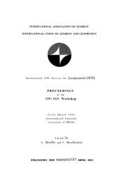
errors, and can therefore be used as calibrations to produce common station data that hassubstantially reduced noise.Theoretically, if we calibrate data for the post-fit residuals and feed only a subset of thatcalibrated data back into the estimation process, it can be easily shown that we get exactlythe same solution (provided there is sufficient data to prevent a rank deficiency).Therefore, we can think of this calibrated data set as simply a different representation of theGAC’s solution. Note that there is no reason to use carrier phase any more: we can just aseasily calibrate the pseudorange data provided the GAC has reduced the pseudorange andcarrier phase data simultaneously in the filter. We therefore no longer have to estimatecarrier phase ambiguity parameters when reusing this “noise-calibrated pseudorange,”When using such calibrated data for a common station in a regional network, it is importantto heavily weight that data relative to the raw data from other stations. Theoretically, onemight expect that the determination of a baseline from a regional station to a common noisecalibratedstation will be improved by ti. In practice, we should recognize that the post-fitresiduals we would have obtained were the regional station in the global solution, wouldhave been correlated to some degree. These correlations can arise, for example, from orbitrnismodeling or antenna phase center variations. Such correlated errors will be absorbed inpart by the satellite clock parameters when computing the regional solution (or equivalently,will be difference away). But there is a potential problem when we calibrate the noisefrom only one station’s data when that noise is correlated with a nearby station. Theregional solution can no longer absorb this correlated component of error.Hence the question of how much improvement can be expected depends upon the degree towhich post-fit residuals are correlated, and can only be answered by tests with real data,which will be done shortly. It is potentially a powefil tool for reducing multipath effectsat the common sites.4.1 Introduction4. EXAMPLESAn examination of the current list of operational <strong>IGS</strong> tracking stations (Figure 7) revealsthat several distinct regional clusters are already in operation today, e.g., The “WesternEuropean cluster”, the “Canadian cluster” the Western Canadian Geodetic Array (WCDA)[Draggert et al., 1993] in British Columbia, and the Permanent GPS Geodetic Array(PGGA) in southern California, The first two clusters serve primarily as active controlnetworks while the latter two clusters have been designed to study the kinematics of plateboundary deformation and can be considered among the first <strong>IGS</strong> customers. In thissection we present several scenarios and examples of distributed processing by referring toPGGA/<strong>IGS</strong> activities at Scripps Institution of Oceanography (S10). In the nomenclature ofthis paper, S10 plays the role of a GAC, NAC and RAC.4.2 The Permanent GPS Geodetic ArrayThe Permanent GPS Geodetic Array (PGGA) is a network of continuously operating P-code receivers providing an uninterrupted record of crustal motion in near real time (Figure7) [Bock and Shimaa’a, 1990; Bock, 1991; Lindqwister et aL, 1991], Stations are spacedapproximately 100 km apart to span the Pacific-North American plate boundary in southernCalifornia. The ability of the PGGA to monitor crustal deformation due to seismicity wasdemonstrated during the Landers earthquake sequence in June 1992, when small far-fieldcoseismic displacements were accurately detected at all PGGA stations with respect to the79
.d<strong>IGS</strong> TRACKING NETWORK0 GPS sites processed daiiy at SiOPGGA NETWORK(Southern California)240” 244”36”Collocations: ■ VLBI o SLR32”‘m/l.,:.\ 4QKOKR\/Figure 7. Permanent global tracking stations of the International GPS Service forGeodynamics (<strong>IGS</strong>) and the Permanent GPS Geodetic Array (PGGA) in southernCalifornia.80
- Page 1 and 2:
●INTERNATIONAL ASSOCIATION OF GEO
- Page 3 and 4:
TABLE OF CONTENTS.FINAL AGENDA . .
- Page 5 and 6:
13:30 NGS14:00 S1014:30 EMR15:00 CO
- Page 7 and 8:
LIST OF PARTICIPANTS:Prof. Gerhard
- Page 10 and 11:
Table 1. Current IGS Analysis Cente
- Page 12 and 13:
The first field identifies the reco
- Page 14 and 15:
Summary InformationThe third produc
- Page 16 and 17:
From Figure 1 we find that there ar
- Page 18:
to define a reference clock in thei
- Page 22 and 23:
SESSION 2(IGS orbit products)
- Page 24 and 25:
1. introductionThe main objectives
- Page 26 and 27:
ecause of the above averaging. This
- Page 28 and 29:
RMS per center (m)o 0 0 0 0 0 oA0Iv
- Page 30:
Scale (ppb)I I I I I 11+-b~ul0Amo&I
- Page 33 and 34: and NGS. Note that the day to day v
- Page 35 and 36: Rotation around X-axis (mas)1&0 0o
- Page 37 and 38: discussed in Section 3 are here see
- Page 39 and 40: -----------------------------------
- Page 41 and 42: Residuals in Meters1 1 1 1 1 1 1=%m
- Page 43 and 44: Residuals inMeters11111cnficJJw-o A
- Page 45 and 46: I I I—Residuals in Meters..—.
- Page 47 and 48: 1111ResidualsMeters,—{44
- Page 49 and 50: Residuals in MetersI I I II I I IIc
- Page 51 and 52: Rms in MetersI 1 ! I 1 10 n0 a0n.ff
- Page 53 and 54: IGS- and the COM-sets, but that the
- Page 55 and 56: Table 4.1 N.A. Baseline Repeatabili
- Page 57 and 58: ..Figure 5.1:Clock solutions for FA
- Page 59 and 60: specifically the preanalysis can be
- Page 61 and 62: discussion, a question as to whethe
- Page 63 and 64: SUMMARY OF SESSION 3This Session be
- Page 65 and 66: IGS POSITION PAPER, IGS ANALYSIS CE
- Page 67 and 68: and Earth orientation parameters (E
- Page 69 and 70: LbPIERS and IGSCentral Bureausand D
- Page 71 and 72: @ IGS will develop instructions, an
- Page 73: 2.2 Analysis Center System DesignFi
- Page 76 and 77: applied to the solution in order to
- Page 78 and 79: ..standard deviations. This is conv
- Page 80 and 81: known, the two solutions will be ad
- Page 84 and 85: International Terrestrial Reference
- Page 86 and 87: Thus, there is the potential of fee
- Page 88 and 89: 90” 100” 110” 120” 130” 1
- Page 91 and 92: adiation parameters for each satell
- Page 93 and 94: Bock, Y., R.I. Abbot, C.C. Counselm
- Page 95 and 96: SUMMARY OF SESSION 4This session st
- Page 97 and 98: INTERNATIONAL EARTH ROTATION SERVIC
- Page 99 and 100: x- differences with IERS0.001”I I
- Page 101 and 102: SUMMARY OF SESSION 5In the last ses
- Page 103 and 104: 1) I(X3 PROCESSING/REPORTS/FORMATSS
- Page 105 and 106: IGS should foster and encourage reg
- Page 107 and 108: ..INTERNATIONAL GPS SERVICE FORGEOD
- Page 109 and 110: ortL.s.4
- Page 111 and 112: 1234567a91011121314IsIt17ItIs2C2122
- Page 113 and 114: . Ruth Neilan16S Central BureauJet
- Page 115 and 116: ON1T.>● Jim ZumbergeJet Propulsio
- Page 117: PROPOSED ORGANIZATION OF THE INTERN