ENVI. Get the Information You Need from Imagery. - Exelis Visual ...
ENVI. Get the Information You Need from Imagery. - Exelis Visual ...
ENVI. Get the Information You Need from Imagery. - Exelis Visual ...

You also want an ePaper? Increase the reach of your titles
YUMPU automatically turns print PDFs into web optimized ePapers that Google loves.
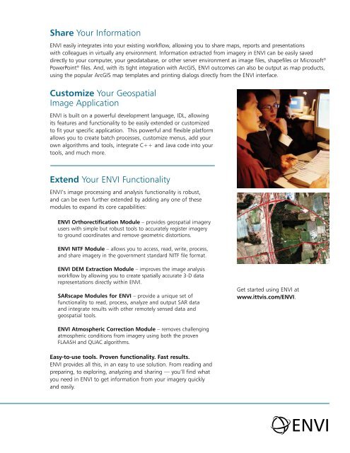
Share <strong>You</strong>r <strong>Information</strong><strong>ENVI</strong> easily integrates into your existing workflow, allowing you to share maps, reports and presentationswith colleagues in virtually any environment. <strong>Information</strong> extracted <strong>from</strong> imagery in <strong>ENVI</strong> can be easily saveddirectly to your computer, your geodatabase, or o<strong>the</strong>r server environment as image files, shapefiles or Microsoft ®PowerPoint ® files. And, with its tight integration with ArcGIS, <strong>ENVI</strong> outcomes can also be output as map products,using <strong>the</strong> popular ArcGIS map templates and printing dialogs directly <strong>from</strong> <strong>the</strong> <strong>ENVI</strong> interface.Customize <strong>You</strong>r GeospatialImage Application<strong>ENVI</strong> is built on a powerful development language, IDL, allowingits features and functionality to be easily extended or customizedto fit your specific application. This powerful and flexible platformallows you to create batch processes, customize menus, add yourown algorithms and tools, integrate C++ and Java code into yourtools, and much more.Extend <strong>You</strong>r <strong>ENVI</strong> Functionality<strong>ENVI</strong>’s image processing and analysis functionality is robust,and can be even fur<strong>the</strong>r extended by adding any one of <strong>the</strong>semodules to expand its core capabilities:<strong>ENVI</strong> Orthorectification Module – provides geospatial imageryusers with simple but robust tools to accurately register imageryto ground coordinates and remove geometric distortions.<strong>ENVI</strong> NITF Module – allows you to access, read, write, process,and share imagery in <strong>the</strong> government standard NITF file format.<strong>ENVI</strong> DEM Extraction Module – improves <strong>the</strong> image analysisworkflow by allowing you to create spatially accurate 3-D datarepresentations directly within <strong>ENVI</strong>.SARscape Modules for <strong>ENVI</strong> – provide a unique set offunctionality to read, process, analyze and output SAR dataand integrate results with o<strong>the</strong>r remotely sensed data andgeospatial tools.<strong>Get</strong> started using <strong>ENVI</strong> atwww.ittvis.com/<strong>ENVI</strong>.<strong>ENVI</strong> Atmospheric Correction Module – removes challengingatmospheric conditions <strong>from</strong> imagery using both <strong>the</strong> provenFLAASH and QUAC algorithms.Easy-to-use tools. Proven functionality. Fast results.<strong>ENVI</strong> provides all this, in an easy to use solution. From reading andpreparing, to exploring, analyzing and sharing — you’ll find whatyou need in <strong>ENVI</strong> to get information <strong>from</strong> your imagery quicklyand easily.<strong>ENVI</strong>