ENVI. Get the Information You Need from Imagery. - Exelis Visual ...
ENVI. Get the Information You Need from Imagery. - Exelis Visual ...
ENVI. Get the Information You Need from Imagery. - Exelis Visual ...

Create successful ePaper yourself
Turn your PDF publications into a flip-book with our unique Google optimized e-Paper software.
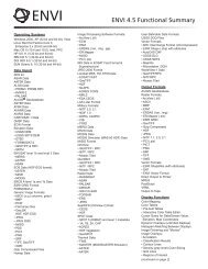
<strong>ENVI</strong> 4.8 Functional SummaryOperating SystemsWindows XP SP2 (Intel/AMD 32- & 64-bit)Windows Vista (Intel/AMD 32- & 64-bit)Windows 7 (Intel/AMD 32- & 64-bit)Linux Kernel 2.6.x (Intel/AMD 32- & 64-bit)Mac OS X 10.5.x (Intel 32- & 64-bit)Max OS X 10.6 (Intel 32- & 64-bit)Sun Solaris 10 (SPARC 32- & 64-bit)Data ImportRaster Formats:• ADRG• ArcView Raster BIL• ASCII (x,y,z & gridded)• Binary (flat)• BMP• CADRG• CIB• DPPDB (with license)• DTED (levels 0, 1, 2)• ECW• <strong>ENVI</strong> Raster• <strong>ENVI</strong> Gzip Compressed• ER Mapper ERS• ERDAS IMAGINE (.img, .ige, .lan)• ESRI Geodatabase Raster Dataset:• Personal (.mdb)• File (.gdb)• Enterprise (.sde)• ESRI GRID• GeoJP2 / GeoJ2K• GeoTIFF• HDF4• HDF-EOS• JPEG• JPEG2000• MrSID (including MG3)• NITF 1.1, 2.0, 2.1 (with license)• NSIF 1.0 (with license)• PCI PIX• PDS• PICT• PNG• RemoteView R-Set (with license)• SRF• SRTM DEM• TFRD (with license)• TIFF• USGS DOQ• USGS DRG• USGS Native DEM• USGS SDTS DEM• XWDVector Formats:• ARC/INFO Interchange• AutoCAD DXF• <strong>ENVI</strong> Vector File• ESRI Geodatabase Feature Class:• Personal (.mdb)• File (.gdb)• Enterprise (.sde)• ESRI Layer• ESRI Shapefile• MapInfo MIF• Microstation DGN• USGS DLGLiDAR Formats:• ASCII• LASMultispectral Sensors:• ADS40• ALOS AVNIR-2• ALOS PRISM• ALSAT-1• ASTER• ATSR• AVHRR• CARTOSAT-1• DMSP (NOAA)• <strong>ENVI</strong>SAT AATSR• <strong>ENVI</strong>SAT MERIS• EROS• FORMOSAT-2• GeoEye-1• IKONOS• IRS• KOMPSAT-2• Landsat MSS, TM, ETM+• MAS-50• MASTER• MISR• MODIS• NigeriaSat-1• OrbView-3• RapidEye• SeaWiFS• QuickBird• SPOT• TIMS• UK-DMCSat-1• WorldView-1• WorldView-2Hyperspectral Sensors:• AISA• ARTEMIS (with license)• AVIRIS• CASI• HyMap• Hyperion• HyperScan• HySpex• MIVIS• PROBE-1• ProspecTIRRadar Sensors:• AIRSAR• ALOS PALSAR• COSMO-SkyMed• <strong>ENVI</strong>SAT ASAR• ERS• JERS• RADARSAT-1• RADARSAT-2• SIR-C / X-SAR• TOPSARRemore Connections:• IAS Server• JPIP• OGC WCS• OGC WMSSpectral Libraries:• ASCII• <strong>ENVI</strong> SLI• ASD Indico• MRSLAnnotations:• <strong>ENVI</strong> Annotation• <strong>ENVI</strong> Zoom AnnotationOutput FormatsRaster Formats:• ArcView Raster BIL• ASCII (x,y,z & gridded)• BMP• DTED (levels 0, 1, 2)• <strong>ENVI</strong> Raster• <strong>ENVI</strong> Gzip Compressed• ER Mapper ERS• ERDAS IMAGINE (.img)• ESRI Geodatabase Raster Dataset:• Personal (.mdb)• File (.gdb)• Enterprise (.sde)• ESRI GRID• GeoJP2 / GeoJ2K• GeoTIFF• HDF4• JPEG• JPEG2000• NITF 2.0, 2.1 (with license)• PICT• PCI PIX• PNG• SRF• TIFF• XWDVector Formats:• AutoCAD DXF• <strong>ENVI</strong> EVF• ESRI Geodatabase Feature Class:• Personal (.mdb)• File (.gdb)• Enterprise (.sde)• ESRI ShapefileO<strong>the</strong>r Formats:• Direct To Printer• Google Earth KML• MPEG• PostScript• VRMLChip Display To:• ArcMap• <strong>ENVI</strong> Raster• ESRI Geodatabase Raster Dataset• JPEG• JPEG2000 / GeoJP2• NITF 2.0, 2.1 (with license)• PowerPoint PPT• Printer• TIFF / GeoTIFFExport Map To:• AI• BMP• EMF• EPS• GIF• JPEG• PDF• PNG• Printer• SVGpg. 1