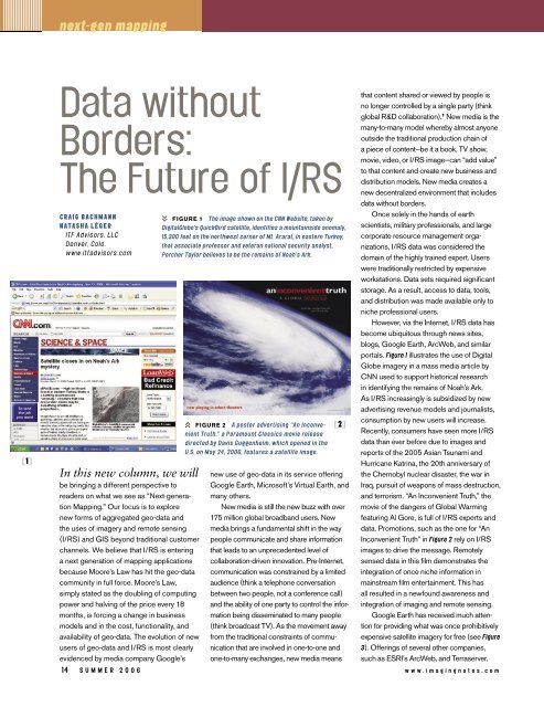
next-gen mapping[1]Data withoutBorders:The Future of I/RSCraig BachmannNatasha LÉgerITF Advisors, LLCDenver, Colo.www.itfadvisors.comIn this new column, we willbe bringing a different perspective toreaders on what we see as “Next-generationMapping.” Our focus is to explorenew forms of aggregated geo-data andthe uses of imagery and remote sensing(I/RS) and GIS beyond traditional customerchannels. We believe that I/RS is enteringa next generation of mapping applicationsbecause Moore’s Law has hit the geo-datacommunity in full force. Moore’s Law,simply stated as the doubling of computingpower and halving of the price every 18months, is forcing a change in businessmodels and in the cost, functionality, andavailability of geo-data. The evolution of newusers of geo-data and I/RS is most clearlyevidenced by media company Google’sFigure 1 The image shown on the CNN Website, taken byDigitalGlobe’s QuickBird satellite, identifies a mountainside anomaly,15,300 feet on the northwest corner of Mt. Ararat, in eastern Turkey,that associate professor and veteran national security analyst,Porcher Taylor believes to be the remains of Noah’s Ark.Figure 2 A poster advertising “An InconvenientTruth,” a Paramount Classics movie releasedirected by Davis Guggenheim, which opened in theU.S. on May 24, 2006, features a satellite image.[2]new use of geo-data in its service offeringGoogle Earth, Microsoft’s Virtual Earth, andmany others.New media is still the new buzz with over175 million global broadband users. Newmedia brings a fundamental shift in the waypeople communicate and share informationthat leads to an unprecedented level ofcollaboration-driven innovation. Pre-Internet,communication was constrained by a limitedaudience (think a telephone conversationbetween two people, not a conference call)and the ability of one party to control the informationbeing disseminated to many people(think broadcast TV). As the movement awayfrom the traditional constraints of communicationthat are involved in one-to-one andone-to-many exchanges, new media meansthat content shared or viewed by people isno longer controlled by a single party (thinkglobal R&D collaboration). 1 New media is themany-to-many model whereby almost anyoneoutside the traditional production chain ofa piece of content—be it a book, TV show,movie, video, or I/RS image—can “add value”to that content and create new business anddistribution models. New media creates anew decentralized environment that includesdata without borders.Once solely in the hands of earthscientists, military professionals, and largecorporate resource management organizations,I/RS data was considered thedomain of the highly trained expert. Userswere traditionally restricted by expensiveworkstations. Data sets required significantstorage. As a result, access to data, tools,and distribution was made available only toniche professional users.However, via the Internet, I/RS data hasbecome ubiquitous through news sites,blogs, Google Earth, ArcWeb, and similarportals. Figure 1 illustrates the use of DigitalGlobe imagery in a mass media article byCNN used to support historical researchin identifying the remains of Noah’s Ark.As I/RS increasingly is subsidized by newadvertising revenue models and journalists,consumption by new users will increase.Recently, consumers have seen more I/RSdata than ever before due to images andreports of the 2005 Asian Tsunami andHurricane Katrina, the 20th anniversary ofthe Chernobyl nuclear disaster, the war inIraq, pursuit of weapons of mass destruction,and terrorism. “An Inconvenient Truth,” themovie of the dangers of Global Warmingfeaturing Al Gore, is full of I/RS experts anddata. Promotions, such as the one for “AnInconvenient Truth” in Figure 2 rely on I/RSimages to drive the message. Remotelysensed data in this film demonstrates theintegration of once niche information inmainstream film entertainment. This hasall resulted in a newfound awareness andintegration of imaging and remote sensing.Google Earth has received much attentionfor providing what was once prohibitivelyexpensive satellite imagery for free (see Figure3). Offerings of several other companies,such as ESRI’s ArcWeb, and Terraserver.14 s u m m e r 2 0 0 6 w w w . i m a g i n g n o t e s . c o m
[3]com’s clearinghouse for imagery, alsoexpand the use of geo-data. These examplesare only the beginning, assuming this newportal approach follows other industries; notonly will new applications emerge, but newbusiness models will, as well. For example,Terraserver has established relationshipswith most of the commercial satellite imageryproviders and allows users to choose thesource and date of the image. At this time,free imagery appears to be used by thegeneral public as simply a nifty new application—“agee-I-can-zoom-in-on-my-house” kindof thing—and as news information. However,we can expect MSN Virtual Earth to presentsomething new due to Microsoft’s acquisitionof Boulder, Colo.-based Vexcel (see featurearticle on page 20).As broadband adoption rates continue torise around the world, the online world is nowone in which users of every type—students,professionals, academics, researchers,techies, concerned citizens, and hobbyists—developcommunities of shared interestsand therefore of shared data applications.As these examples illustrate, the Internetprovides a platform for “connecting manydots” for the multi-layers of I/RS, GIS, GPS,and field data. As geo-data professionalsknow, an inevitable demand for locationbasedviews and analyses arises from theability to be connected 24/7. From thebeginning, I/RS depended on technologicalinnovation to advance geo-data aggregationand integration: ERTS-1, MSS, Telsat, SPOT;then “arcs and info” overlaid on satellitephotography; polygon analysis applied toremote sensing data; GPS enabling moreaccurate, efficient field data capture; and lastmonth’s Russian launch of a remote sensingsatellite. With each innovation, a new globalset of users has emerged.New virtual communities no longerconstrained by accepted business practicesnow have access to I/RS as they participatein environmental and community-basedprojects that span drought control, conservation,climate change, natural disasters, andrecreational use of nature, to name just afew. For example, scientists traditionallyrelied on armies of students or contractors togather field information. Today, with a GPS,a mobile device, and an Internet connection,w w w . i m a g i n g n o t e s . c o many concerned citizen has the ability toprovide scientists with local geo-coded datathat can reduce significantly field data acquisitioncosts. As GPS has become availablein cars, on cellphones and on PDAs, it haspassed from the hands of professionals tohikers, campers, hobbyists, and kids doingscience projects. Everyone can participate inand use location-based services that includedigital I/RS data: this is truly data withoutborders.As we at ITF provide strategy to innovation-drivenindustries, one of our offeringsincludes scenarios based on economic,political, and social assumptions that driveplausible futures. Many of these scenariosinclude location-based services that utilizeI/RS. New wireless applications, globalization,and security all have inherent needs forI/RS in the future. New location services,from personal questions such as “Where aremy kids and family?” to traffic and 911 alerts,are developed every week, but what wehave found to be key new media drivers arethe rapidly growing online communities andaffiliation groups.In some cases these communitieswithout borders will collaborate andinnovate on issues that extend beyondgovernment’s presumed authorityover certain pieces of information andprojects. Online sharing of data of alltypes has begun the unforeseen demandof geo-data and will fuel the “long tail”of unique users. These new users willcollaborate in ways that blur the lines oftraditional private, public, and individualdistribution of products.Figure 3 Google Earth 3D screen shotshows the Colorado River in the Grand Canyon.1 Crosbie, Vin. 2002. What is New Media?,White Paper. www.digitaldeliverance.com/philosophy/definition/definition.htmlCraig Bachmann and NatashaLÉger are partners in ITF Advisors, LLC,an independent consulting firm with afocus on next-generation strategy and ontranslating the increasingly complex newmedia business environment’s impacton business models, markets, and users.Craig Bachmann was a pioneer in the useof GIS by utilities and communicationscompanies and has participated in manymilestones along the path of geo-dataaggregation. Craig Bachmann and NatashaLéger have combined their strategy andscenario planning expertise in the fields ofcommunications, utilities, mapping, publicpolicy, and international trade to providetheir clients with a dynamic, comprehensiveand innovative perspective on therisks and opportunities presented by thenew media environment. Natasha Léger isalso a published scenario-planning authorand an Adjunct Professor at the Universityof Denver’s Institute for Public PolicyStudies.s u m m e r 2 0 0 6 15