

download PDF - Imaging Notes
download PDF - Imaging Notes
download PDF - Imaging Notes
- No tags were found...

Create successful ePaper yourself
Turn your PDF publications into a flip-book with our unique Google optimized e-Paper software.
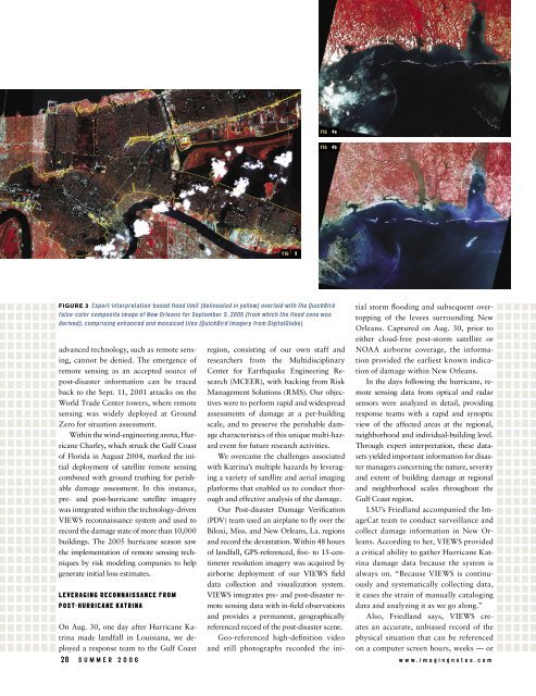
FIG4aFIG4bFIG 3Figure 3 Expert-interpretation-based flood limit (delineated in yellow) overlaid with the QuickBirdfalse-color composite image of New Orleans for September 3, 2005 (from which the flood zone wasderived), comprising enhanced and mosaiced tiles (QuickBird Imagery from DigitalGlobe).advanced technology, such as remote sensing,cannot be denied. The emergence ofremote sensing as an accepted source ofpost-disaster information can be tracedback to the Sept. 11, 2001 attacks on theWorld Trade Center towers, where remotesensing was widely deployed at GroundZero for situation assessment.Within the wind-engineering arena, HurricaneCharley, which struck the Gulf Coastof Florida in August 2004, marked the initialdeployment of satellite remote sensingcombined with ground truthing for perishabledamage assessment. In this instance,pre- and post-hurricane satellite imagerywas integrated within the technology-drivenVIEWS reconnaissance system and used torecord the damage state of more than 10,000buildings. The 2005 hurricane season sawthe implementation of remote sensing techniquesby risk modeling companies to helpgenerate initial loss estimates.Leveraging Reconnaissance fromPost-Hurricane KatrinaOn Aug. 30, one day after Hurricane Katrinamade landfall in Louisiana, we deployeda response team to the Gulf Coastregion, consisting of our own staff andresearchers from the MultidisciplinaryCenter for Earthquake Engineering Research(MCEER), with backing from RiskManagement Solutions (RMS). Our objectiveswere to perform rapid and widespreadassessments of damage at a per-buildingscale, and to preserve the perishable damagecharacteristics of this unique multi-hazardevent for future research activities.We overcame the challenges associatedwith Katrina’s multiple hazards by leveraginga variety of satellite and aerial imagingplatforms that enabled us to conduct thoroughand effective analysis of the damage.Our Post-disaster Damage Verification(PDV) team used an airplane to fly over theBiloxi, Miss. and New Orleans, La. regionsand record the devastation. Within 48 hoursof landfall, GPS-referenced, five- to 15-centimeterresolution imagery was acquired byairborne deployment of our VIEWS fielddata collection and visualization system.VIEWS integrates pre- and post-disaster remotesensing data with in-field observationsand provides a permanent, geographicallyreferenced record of the post-disaster scene.Geo-referenced high-definition videoand still photographs recorded the initialstorm flooding and subsequent overtoppingof the levees surrounding NewOrleans. Captured on Aug. 30, prior toeither cloud-free post-storm satellite orNOAA airborne coverage, the informationprovided the earliest known indicationof damage within New Orleans.In the days following the hurricane, remotesensing data from optical and radarsensors were analyzed in detail, providingresponse teams with a rapid and synopticview of the affected areas at the regional,neighborhood and individual-building level.Through expert interpretation, these datasetsyielded important information for disastermanagers concerning the nature, severityand extent of building damage at regionaland neighborhood scales throughout theGulf Coast region.LSU’s Friedland accompanied the ImageCatteam to conduct surveillance andcollect damage information in New Orleans.According to her, VIEWS provideda critical ability to gather Hurricane Katrinadamage data because the system isalways on. “Because VIEWS is continuouslyand systematically collecting data,it eases the strain of manually catalogingdata and analyzing it as we go along.”Also, Friedland says, VIEWS createsan accurate, unbiased record of thephysical situation that can be referencedon a computer screen hours, weeks — or28 s u m m e r 2 0 0 6 w w w . i m a g i n g n o t e s . c o m


