PMA209 2012 Core Avionics Master Plan - NAVAIR - U.S. Navy
PMA209 2012 Core Avionics Master Plan - NAVAIR - U.S. Navy
PMA209 2012 Core Avionics Master Plan - NAVAIR - U.S. Navy

You also want an ePaper? Increase the reach of your titles
YUMPU automatically turns print PDFs into web optimized ePapers that Google loves.
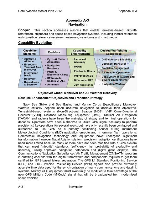
<strong>Core</strong> <strong>Avionics</strong> <strong>Master</strong> <strong>Plan</strong> <strong>2012</strong> Appendix A-3Scope:Appendix A-3NavigationThis section addresses avionics that enable terrestrial-based, aircraftreferenced,shipboard and space-based navigation systems, including inertial referenceunits, position reference receivers, antennas, waveforms and chart media.Capability Evolution:Capability Capability Desired WarfightingEnablersElements Enhancements Capabilities• Attitude &Altitude• En-route &Terminal AreaManeuver• InformationMedia• Recovery• Robustness& Security• Gyros & RadarAltimeters• NavigationReceivers• Paper &Electronic Charts• RF NavAids,Radars, JPALS• Antennas• IncreasedAccuracy• MGUE• Electronic Charts• Improved ACLS• Differential GPS• Jam ResistanceBaseline Enhancement Objectives and Transition Strategy.• Global Access & Mobility• Dominant Maneuver• Precision Engagement• All Weather Operations• Deployment to Austere andSevere Environments• Navigation Warfare•Objective: Global Maneuver and All-Weather Recovery<strong>Navy</strong> Sea Strike and Sea Basing and Marine Corps Expeditionary ManeuverWarfare critically depend upon accurate navigation to achieve their objectives.Terrestrial-based systems (Non-Directional Beacon [NDB], VHF Omni-DirectionalReceiver [VOR], Distance Measuring Equipment [DME], Tactical Air Navigation[TACAN] and radars) have been the mainstay of airway and terminal operations fordecades. Operators have been authorized to utilize GPS signal accuracy to performprecision strike operations for several years, but have only recently been configured andauthorized to use GPS as a primary positioning sensor during InstrumentMeteorological Conditions (IMC) navigation enroute and in terminal flight operations.Commercial navigation technology and equipment have undergone significanttransformation; however Naval Aviation platform precision navigation certifications havebeen more limited because many of them have not been modified with a GPS systemthat can meet “integrity” standards (sufficiently high probability of availability andaccuracy), using approved navigation databases and digital glass displays. TheCommunications Navigation Surveillance / Air Traffic Management (CNS/ATM) programis outfitting cockpits with the digital frameworks and components required to get themcertified for GPS-based lateral separation. The GPS L1 Standard Positioning Service(SPS) and L1/L2 Precise Positioning Service (PPS) signals also provide extremelyaccurate time data used for the synchronization of many communications and datalinksystems. Military GPS equipment must eventually be modified to take advantage of thenew GPS Military Code (M-Code) signal that will be broadcasted from modernizedspace vehicles.A-3 Navigation 1