Newsletter No. 6 - Blue Mountains Association of Cultural Heritage ...
Newsletter No. 6 - Blue Mountains Association of Cultural Heritage ...
Newsletter No. 6 - Blue Mountains Association of Cultural Heritage ...

You also want an ePaper? Increase the reach of your titles
YUMPU automatically turns print PDFs into web optimized ePapers that Google loves.
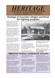
Tyldesley the village that disappearedThe spine <strong>of</strong> the Great DividingRange leading north fromWallerawang to Mudgee is rich inminerals. Since the late 19 th centurythe region along the “Mudgee Line”has seen gold, coal and oil shalemining, limestone quarrying, andthe manufacture <strong>of</strong> petroleumproducts and cement. Following theconstruction <strong>of</strong> the Wallerawang toMudgee branch line railway fromthe early 1880s coal miningcommenced at various placesincluding Cullen Bullen.Between 1888 and 1960 the areaaround Cullen Bullen hosted sixunderground coal mines. Two <strong>of</strong>these mines, Tyldesley andInvincible were major producersand employers in the early to mid20 th century. To alleviate coalshortages experienced immediatelyafter World War II the Joint CoalBoard encouraged the development<strong>of</strong> open cut coal mining in the area.The open cut mines were worked bythe army and air force during the1949 coal strike.The village <strong>of</strong> Tyldesley grewaround the headworks <strong>of</strong> the GreatWestern Colliery and its successorTyldesley Colliery from 1904.Like many coal communities thevillage consisted <strong>of</strong> shanties built oncolliery land using a mixture <strong>of</strong>traditional building methods such aswattle and daub and foundmaterials including sacking,kerosene tins and explosives boxes.Tyldesley Colliery ceased operationin 1960 and the village was largelyabandoned by the mid 1960s. Littleremained <strong>of</strong> the village by the timea new open cut mine wasdeveloped on the site from 2001.The village has all but disappearedfrom the landscape.The City <strong>of</strong> Greater Lithgow MiningMuseum Inc is preparing to printRay Christison’s latest book on thehistory <strong>of</strong> coalmining in the WesternCoalfield. This book will be in asimilar format to Lithgow State CoalMine a pictorial history published inMay this year.The book uses a mixture <strong>of</strong>historical records, newspaperreports and the memories <strong>of</strong> formerresidents to present the story <strong>of</strong>Pictured is water bailer, Harry McAlpine, colliery engineer, JamesWilson and the colliery dog Rex at Tyldesley in the early 1950s. Harryand his wife Annie also ran the post <strong>of</strong>fice and general store atTyldesley.coal mining around Cullen Bullenand Tyldesley. The book isillustrated with 19 maps and plans,and over 70 photographs <strong>of</strong> thedistrict’s mines and the village <strong>of</strong>Tyldesley.The new book, focuses on the story<strong>of</strong> the Great Western/TyldesleyColliery that operated from 1904 to1960 and the village that grewaround the mine’s headworks.It also includes a brief history <strong>of</strong> theneighbouring village <strong>of</strong> CullenBullen and the collieries thatoperated in the Cullen Bullendistrict, including:Cullen Bullen Colliery 1888-1900, Shepherd and Massey’sMine1888, Invincible Colliery 1905-1957, Renown Colliery 1921-1929,1940-1954, Invincible <strong>No</strong>.2 Colliery1925-1931, Ben Bullen Colliery1926-1929, Wattle Mount Colliery1929, 1949-1950s, Ben BullenOpen Cut 1946-1955,Red Springs Open Cut 1947-1955,Cullen Main Open Cut 1948-1952 ,Beaumaris Open Cut 1949-1953.It is planned to release the book by<strong>No</strong>vember 30, 2009.The City <strong>of</strong> Greater Lithgow MiningMuseum is <strong>of</strong>fering a prepublicationdiscount for ordersplaced before this date.Pre-publication order form and areseller order form can bedownloaded from the City <strong>of</strong>Greater Lithgow Mining Museumwebsite www.statemine.org.auBULL’S CAMPMYTHSDEBUNKEDWhen Major Thomas Mitchellbegan his road deviation works adepot was set up in the 1830s ata site known as Twenty-MileHollow [now Woodford]. Convictsengaged in road constructionwere camped here, as well astheir military guards.In 1842 Captain Bull was placedin charge <strong>of</strong> the camp. Two storerooms were excavated in the s<strong>of</strong>tsandstone; these were not cells,as the popular notion has it.<strong>No</strong>r were parallel grooves in thenearby rock surface cut to givethe flagellator a foothold [or todrain away the blood <strong>of</strong> theconvict being flogged]; they wereon a path to a nearby kitchen andwere most likely put there toprevent slipping on the slopingrock surface. Source: Places <strong>of</strong>Historic Interest on the <strong>Blue</strong><strong>Mountains</strong> published by theSpringwood Historical Societyfrom data provided the Society’sresearcher Allan Searle 1977.HERITAGE15<strong>No</strong>vember - December 2009