User Guide - Digimap
User Guide - Digimap
User Guide - Digimap
- No tags were found...

Create successful ePaper yourself
Turn your PDF publications into a flip-book with our unique Google optimized e-Paper software.
1:50 000 Scale Colour Raster and Gazetteer<strong>User</strong> guideContentsSectionPage noPreface ..................................................................................................................................................3Chapter 1 Introduction .............................................................................................................................51:50 000 Scale Colour Raster...................................................................................................51:50 000 Scale Gazetteer .........................................................................................................5Chapter 2 Content.....................................................................................................................................71:50 000 Scale Colour Raster...................................................................................................71:50 000 Scale Gazetteer .........................................................................................................7Chapter 3 Scale.........................................................................................................................................9Coordinates...............................................................................................................................9Coverage...................................................................................................................................9Chapter 4 Formats..................................................................................................................................10TIFF.........................................................................................................................................10TIFF compressions explained............................................................................................10BMP ........................................................................................................................................10BMP structure .........................................................................................................................10PCX.........................................................................................................................................10PCX structure..........................................................................................................................10Chapter 5 Data compression.................................................................................................................11Image compression.................................................................................................................11Lossless compression .......................................................................................................11Lossy compression ............................................................................................................11TIFF.........................................................................................................................................11Chapter 6 Georeferencing .....................................................................................................................12Chapter 7 Revision .................................................................................................................................13Annexe A Product and service performance report form ..................................................................14v2.0.1 – 01/2008D05300_191:50 000 Scale Colour Raster and Gazetteer user guide contents v2.0.1 – 01/2008 © Crown copyright Page 2 of 33
PrefaceThis user guide (hereafter referred to as the guide) is designed to provide an overview of1:50 000 Scale Colour Raster and 1:50 000 Scale Gazetteer (hereafter referred to as the product) and itgives guidelines and advice on how a customer might derive the maximum benefit from the product. Itassumes a general knowledge of geographic information. If you find an error or omission in this guide, orotherwise wish to make a comment or suggestion as to how we can improve the guide, please contact us atthe address shown below under contact details or complete the product and service performance report format annexe A and return it to us.Contact detailsOur Customer Service Centre will be pleased to deal with your enquiries:Customer Service CentreOrdnance SurveyRomsey RoadSOUTHAMPTONSO16 4GUGeneral enquiries (calls charged at local rate): 08456 05 05 05Dedicated Welsh Language HelpLine: 08456 05 05 04Textphone (deaf and hard of hearing users only please): +44 (0)23 8079 2906Email: customerservices@ordnancesurvey.co.ukor visit the Ordnance Survey website at: www.ordnancesurvey.co.ukUse of the productThe terms and conditions upon which the product, including this guide, is made available to you and yourorganisation are contained in the customer contract made between you and Ordnance Survey. If there is aninconsistency between the terms of your customer contract and this guide, then the terms of your customercontract prevail. If you or your organisation has not signed a valid current customer contract then you are notentitled to use the product.Purpose and disclaimerThis guide is provided for guidance only and does not constitute any warranty, representation, undertaking,commitment or obligation (express or implied) about the product or its suitability for any particular or intendedpurpose. Any warranties, representations, undertakings, commitments and obligations given byOrdnance Survey about the product and/or its suitability for any particular or intended purpose are set out inyour customer contract. It is your responsibility to ensure that this product is suitable for your intendedpurpose.Ordnance Survey does not accept any liability (whether for breach of contract, negligence or otherwise) forany loss or liability you or any third party may suffer in relying on this guide and any guidance, suggestion,advice or explanation provided in it. Any liability that Ordnance Survey has to you in relation to the product,its supply, use, accuracy, data supplied, functionality or any other liability arising out of or in connection withthe product is limited as set out in your customer contract.We may change the information in this guide at any time without notice.We do not accept responsibility for the content of any third party websites referenced or accessed in orthrough this guide, any contractual documentation, and/or the Ordnance Survey website.Copyright in this guideThis guide (including for the avoidance of doubt any mapping images reproduced herein) is© Crown copyright 2008. All rights reserved.Any part of this guide may be copied for use internally in your organisation or business so that you can usethe product for the purpose for which it is licensed to your organisation or business (but not otherwise).1:50 000 Scale Colour Raster and Gazetteer user guide preface v2.0.1 – 01/2008 © Crown copyright Page 3 of 33
No part of this guide may be reproduced or transmitted in any form or by any means (including electronically)for commercial exploitation without the prior written consent of Ordnance Survey.No part of this guide may be copied or incorporated in products, services or publications that you generatefor onward sale, or as free promotional or support materials, without the prior written consent ofOrdnance Survey.Data copyright and other intellectual property rightsThe Crown (or, where applicable, Ordnance Survey’s suppliers) owns the intellectual property rights inOrdnance Survey digital map data.Full details of the terms and conditions under which Ordnance Survey digital map data may be processedand/or manipulated or copied by a customer – whether or not for use on PCs or workstations or for makinghard copies – are available from the Customer Service Centre, please see contact details. You should checkthe terms and conditions with us before using the data. It is also the responsibility of the holder of the digitalmap data to ensure that any plotted or printed output contains the required copyright and databaseacknowledgements in a conspicuous position.TrademarksOrdnance Survey, the OS Symbol, Landranger and OS are registered trademarks of Ordnance Survey, thenational mapping agency of Great Britain.Acrobat Reader and Adobe are registered trademarks of Adobe Systems Incorporated.Intel is a registered trademark of Intel Corporation.Motorola is a registered trademark of Motorola, Inc.UNIX is a registered trademark of X/Open Company LtdWindows is a registered trademark of Microsoft Corporation.Back-up provision of the productYou are advised to copy the supplied data to a back-up medium.Using this guideThe documentation is supplied in portable document format (PDF) only. Free Adobe ® Acrobat Reader ®software, which displays the guide, incorporates search and zoom facilities and allows you to navigatewithin. Hyperlinks are used to navigate between associated parts of the guide and to relevant Internetresources by clicking on the blue hyperlinks and the table of contents.If you are unfamiliar with any words or terms used and require clarification please refer to the glossary at theend of the document.1:50 000 Scale Colour Raster and Gazetteer user guide preface v2.0.1 – 01/2008 © Crown copyright Page 4 of 33
Chapter 1Introduction1:50 000 Scale Colour Raster1:50 000 Scale Colour Raster is a mid-scale product in Ordnance Survey’s raster portfolio, providing a rasterimage of the popular OS Landranger Map series. 1:50 000 Scale Colour Raster is available in colour and ina number of file formats. An example of the data is shown in figure 1 below.Figure 1: an extract of 1:50 000 Scale Colour Raster1:50 000 Scale Colour Raster provides an image where the detail has been converted to a grid of pixels,which can then be displayed on computer screens. The product covers all of Great Britain and is supplied astiles aligned to the National Grid. Data is converted into a raster format at a resolution of 254 dots per inch(dpi) and a pixel is equivalent to 5 metres on the ground. This resolution has been chosen as it maintains thenecessary clarity for text shown on the map.The product can be overlaid with other Ordnance Survey products or a customer’s own geographic/businessdata, besides providing a detailed geographic context in its own right.1:50 000 Scale Colour Raster is produced to provide customers with a detailed product that could be madeavailable in a number of different formats to provide either a map of an area when used on its own or as ameans of providing geographic context to help a customer visualise their own data.1:50 000 Scale Colour Raster is supplied as graphic image files that can easily be read by many imagesoftware packages. To view tiles in geographic relation to each other and to create the best context for itsuse with other Ordnance Survey or third-party data, it is recommended that it is used in a geographicalinformation system (GIS).As can be seen from the illustration above, the product provides an excellent overview of the main featuresand communication routes of an area, and this makes 1:50 000 Scale Colour Raster particularly useful fordevelopment and land-use planning, environmental impact analysis, vehicle routing, asset management,marketing analysis, and display and promotion purposes.1:50 000 Scale Gazetteer1:50 000 Scale Gazetteer is a list of distinctive place or feature names from 1:50 000 Scale Colour Raster,with location information. This enables you to easily locate places on the map, geocode your data and buildsearch functionality into applications.1:50 000 Scale Gazetteer contains entries for airports, farms, hills, woodlands, commons and other places,including over 42 000 cities, towns and settlements with coordinates to 1-km resolution.1:50 000 Scale Colour Raster and Gazetteer user guide chapter 1 v2.0.1 – 01/2008 © Crown copyright Page 5 of 33
1:50 000 Scale Gazetteer has the following features:• National coverage is held in one seamless file, enabling you to find locations quickly with minimal datamanagement.• It contains every distinctive name featured on the 1:50 000 Scale Colour Raster product.• It is updated in conjunction with the 1:50 000 Scale Colour Raster revision cycles, giving productconsistency.• Highly detailed, containing over 250 000 names, from farms to cities.1:50 000 Scale Colour Raster and Gazetteer user guide chapter 1 v2.0.1 – 01/2008 © Crown copyright Page 6 of 33
Chapter 2Content1:50 000 Scale Colour Raster1:50 000 Scale Colour Raster shows the following features:• building blocks and important buildings;• roads, public rights of way, cycle networks, paths, tracks;• vegetation type, Forestry Commission access land, National Trust land;• water features and associated detail;• railways and associated detail;• height information;• archaeological and antiquity information;• administrative boundary information;• text;• tourist information – including camping/caravan sites, gardens, golf courses, information centres, naturereserves, car parks, picnic sites, viewpoints and youth hostels; and• rock features.1:50 000 Scale Gazetteer1:50 000 Scale Gazetteer includes records for the following feature types:• cities;• towns;• water features;• forests or woods;• farms*;• antiquities;• hills or mountains; and• other features, including those distinctive names not covered by the above classifications, for example,private houses, isolated buildings, airports, commons, greens and marshes.* Farms that do not contain the word ‘farm’ as part of the name will not be identified under this feature type;they will be listed as other.1:50 000 Scale Colour Raster and Gazetteer user guide chapter 2 v2.0.1 – 01/2008 © Crown copyright Page 7 of 33
Each record contains the information shown in table 1 below:Table 1: record attributesField Field name Full name Description Examplenumber1 SEQ Sequence number Unique sequence number of 86124the record.2 KM_REF Kilometre reference The National Grid 1 km by1 km square the featurefalls within on the 1:50 000scale mapping.ST52653 DEF_NAM Definitive name Distinctive name of thefeature the record describes.4 TILE_REF Tile reference The 1:50 000 Scale ColourRaster tile the feature namefalls within.FeltonST465 LAT_DEG Latitude degrees The latitude and longitude 516 LAT_MIN Latitude minutesdegrees and minutes of the1 km National Grid square23.17 LONG_DEG Longitude degrees the feature name falls 2within.8 LONG_MIN Longitude minutes419 NORTH Northings National Grid position of the 16550010 EAST Eastingscentre point of the 1 kmsquare the feature name352500falls within.11 GMT Greenwich Mean Time Position in relation to theGreenwich Meridian12 CO_CODE County code Code representing thecounty or unitary authorityboundary the definitivename falls within. Seeannexe B for a list.13 COUNTY County name Abbreviated county orunitary authority name.14 FULL_COUNTY Full county name Full county or unitaryauthority name.15 F_CODE Feature code Describes what the featureis. See annexe C forcomplete list of definitions.‘T’ represents town16 E_DATE Edit date The date the record waslast amended.17 UPDATE_CO Update code ‘I’ represents insert‘A’ represents amendment‘D’ represents deletion18 SHEET_1 Primary sheet no The OS Landranger Map 17219 SHEET_2 Second sheet nosheet the feature name fallswithin.18220 SHEET_3 Third sheet no0WNSN SomNorth SomersetT01-MAR-2007IAD1:50 000 Scale Colour Raster and Gazetteer user guide chapter 2 v2.0.1 – 01/2008 © Crown copyright Page 8 of 33
Chapter 3Scale1:50 000 Scale Colour Raster is derived from the source data used to create its graphic counterpart, theOS Landranger Map series.Generalisation is used to emphasise, simplify, select and sometimes omit features to produce a cartographicrepresentation of the landscape at a scale of 1:50 000.The nominal scale of the product is 1:50 000, but recommended minimum-to-maximum scale range is1:15 000 to 1:60 000 scale.It is best viewed between 1:20 000 and 1:50 000 scale.Coordinates1:50 000 Scale Colour Raster is available in National Grid coordinates, which are expressed in metresrelative to an origin set to a point west of the Isles of Scilly. These coordinates can easily be spatially relatedto other surveys, drawings, datasets or Ordnance Survey products. Customers can visit the British NationalGrid pages of Ordnance Survey’s website for more information.Coverage1:50 000 Scale Raster is supplied in standard 20 km by 20 km tiles aligned to the National Grid.1:50 000 Scale Colour Raster and Gazetteer user guide chapter 3 v2.0.1 – 01/2008 © Crown copyright Page 9 of 33
Chapter 4Formats1:50 000 Scale Colour Raster comes in a number of file formats. These are:• TIFF Palette 8-bit (256 colours) uncompressed• TIFF Palette 8-bit (256 colours) with LZW compression• Windows ® BMP 8-bit colour (256 colours) uncompressed• Windows BMP 8-bit colour (256 colours) with RLE compression• PCX 8-bit (256 colours)TIFFTIFF is a file-based format for storing and interchanging raster images, with the most recent version (6.0)published in 1992.There are two types of architecture for a TIFF. Many mainframe computers use what is known as abig-endian (Motorola ® ) architecture. Most modern computers, including personal computers (PCs), use thelittle-endian (Intel ® ) system. 1:50 000 Scale Colour Raster TIFFs are supplied with Motorola architecture.Converting between these two systems is possible but, as a general rule, modern software should beexpected to handle both of these outputs without operator intervention.The 1:50 000 Scale Colour Raster conforms to the TIFF 6.0 standard. Customers are recommended tocontact their system suppliers to ensure that it can read the Motorola/big-endian TIFF architecture.TIFF compressions explainedTIFF LZW is a lossless compression scheme that is supported by virtually all applications that can importTIFF graphics.BMPBMP files are a historic file format for Windows operating system. A compressed BMP format is availableusing Run Length Encoding (RLE). RLE means that the file can be read from start to finish in one pass.BMP structureA BMP file consists of either three or four parts. The first part is a header, which includes the position of theimage and the number of colours to be displayed. This is followed by an information section, which containsthe image width (part 2), height (part 3), and the type of compression (part 4).PCXThe PCX format is a relatively simple format that provides a minimum of compression using RLE.PCX structureThe PCX file itself contains two parts: the first part is called the header, which contains information about theimage; the second part is the image data, which contains actual image data and colour information.1:50 000 Scale Gazetteer is supplied as an ASCII colon separated value file.1:50 000 Scale Colour Raster and Gazetteer user guide chapter 4 v2.0.1 – 01/2008 © Crown copyright Page 10 of 33
Chapter 5Data compressionThe data volumes for each file format are influenced by the level of data compression.Image compressionWhen an image is compressed, duplicated data that has no value is removed or saved in a shorter form,reducing a file’s size. For example, if large areas of water are the same tone, only the value for one pixelneeds to be saved, together with the locations of the other pixels with the same colour. When the image isedited or displayed, the compression process is reversed. When raster is compressed, not only are the datavolumes reduced but the user can download, display, edit and transfer images more quickly.There are two forms of compression: lossless and lossy:Lossless compressionAs its name suggests, lossless compression does not lose information within an image. A losslesscompression retains the original quality of an image when it is uncompressed. This process doesn’t providemuch compression, so file sizes remain large. Lossless compression is used mainly where detail isimportant, such as when planning to make large prints.Lossy compressionThis process degrades images to some degree, meaning that the decompressed image isn't quite the sameas the original. The more an image is compressed, the more degraded it becomes. In many situations, suchas posting images on the Internet or printing small- to medium-sized prints, the image degradation isn’t soobvious. If a lossy compressed image is over-enlarged, the degradation will become apparent and, therefore,1:50 000 Scale Raster is not supplied using this compression.TIFFTIFF is one of the most commonly used lossless image formats. TIFF is primarily designed for raster datainterchange and is supported by numerous image-processing applications. This permits much more efficientaccess to very large files that have been compressed.1:50 000 Scale Colour Raster and Gazetteer user guide chapter 5 v2.0.1 – 01/2008 © Crown copyright Page 11 of 33
Chapter 6GeoreferencingTo be able to view each tile in the correct geographic relation to the National Grid and to each other, the tilesmust be georeferenced. GIS typically provide georeferencing as part of their functionality, but for each set oftiles it is necessary to provide the information on how the tiles should be ordered.Ordnance Survey provides this information in a set of georeferencing files, also known as World files. Acomplete set for 1:50 000 Scale Colour Raster is available to download free of charge from the1:50 000 Scale Colour Raster product page on the Ordnance Survey website.There are several different types of World file. Prior to downloading one of the sets, customers are advisedto check with their system suppliers to find out which type their system supports.The conventions behind the files’ creation can be found in chapter 4 of the technical specification. By usingthe conventions outlined there, this means that other datasets using the same conventions can be importedinto the same GIS to add value to the raster map; for example, overlaying a routing or logistics network overthe map or displaying a customer’s demographic information.The georeferencing files should be saved in the same directory as the files of the map tiles themselves.1:50 000 Scale Colour Raster and Gazetteer user guide chapter 6 v2.0.1 – 01/2008 © Crown copyright Page 12 of 33
Chapter 7RevisionBoth 1:50 000 Scale colour Raster and 1:50 000 Scale Gazetteer are updated via a revision programme.The revision programme for both products mirrors that of the OS Landranger Map series and is determinedby assessing the following factors:• known surveyed change;• change intelligence gathered from a range of sources; and• consideration is given to how long since an area was last revised.Priority is given to prestige sites categorised as significant items of change, such as major road constructionprojects. Significant items of survey change relevant to the scale are captured during the revisionprogramme.Where a line feature ends by intersecting the tile edge, it is matched with its corresponding feature on theadjacent tile so that both features end on the same unique coordinate. The representation of detail acrossthe tile edge will be of a cartographically acceptable standard when plotted or displayed at scale.Changes are applied to the data and supplied to customers in June each year. For 1:50 000 Scale Colour Raster,only tiles that have changed since the previous supply are provided to help with customers’ data management.The full national set of 1:50 000 Scale Gazetteer is supplied each year; changes are indicated by the update code(see chapter 2).1:50 000 Scale Colour Raster and Gazetteer user guide annexe A v2.0.1 – 01/2008 © Crown copyright Page 13 of 33
Annexe AProduct and service performance report formOrdnance Survey welcomes feedback from its customers about 1:50 000 Scale Colour Raster and1:50 000 Scale Gazetteer.If you would like to share your thoughts with us, please print a copy of this form and when completed post orfax it to the address below.Your name: ..........................................................................................................................................................Organisation: .......................................................................................................................................................Address: ...........................................................................................................................................................................................................................................................................................................................................................................................................................................................................................................................Postcode: .............................................................................................................................................................Phone: .................................................................................................................................................................Fax: ......................................................................................................................................................................Email: ...................................................................................................................................................................Quotation or order reference: ..............................................................................................................................Please record your comments or feedback in the space below. We will acknowledge receipt of your formwithin three (3) working days and provide you with a full reply or a status report within 21 working days.If you are posting this form, please send it to:1:50 000 Scale Colour Raster and 1:50 000 Scale Gazetteer Product Manager, Ordnance Survey,Romsey Road, SOUTHAMPTON, SO16 4GU.If you wish to return it by fax, please dial 023 8079 2615.Any personal information that you supply with this report form will be used by Ordnance Survey only in theimprovement of its products and services. It will not be made available to third parties.1:50 000 Scale Colour Raster and Gazetteer user guide annexe A v2.0.1 – 01/2008 © Crown copyright Page 14 of 33
1:50 000 Scale Colour Raster and GazetteerTechnical specificationContentsSectionPage noIntroduction ................................................................................................................................................16Purpose of this specification and disclaimer...........................................................................16Copyright in this specification .................................................................................................16Chapter 1 Specification..........................................................................................................................171:50 000 Scale Colour Raster.................................................................................................171:50 000 Scale Gazetteer .......................................................................................................17Chapter 2 Legend ...................................................................................................................................18Chapter 3 Georeferencing .....................................................................................................................22Chapter 4 Image file directory (TIFF) ....................................................................................................23TIFF.........................................................................................................................................24Colour image directory (TIFF)............................................................................................24Annexe A Glossary.................................................................................................................................25Annexe B 1:50 000 Scale Gazetteer county code list .........................................................................29Annexe C 1:50 000 Scale Gazetteer feature code list .........................................................................33v2.0.1 – 01/20081:50 000 Scale Colour Raster and Gazetteer technical specification contents v2.0.1 – 01/2008 © Crown copyright Page 15 of 33
IntroductionPurpose of this specification and disclaimerThis is the technical specification (hereafter referred to as the specification) applicable to the1:50 000 Scale Colour Raster and 1:50 000 Scale Gazetteer (hereafter referred to as the product), which isreferred to in the Framework Direct Licence, Specific Use Framework Partner Licence or your othercustomer contract for the product.We may change the information in this specification at any time, giving you the notice period specified in thecustomer contract made between you and Ordnance Survey.We do not accept responsibility for the content of any third party websites referenced or accessed in orthrough this specification, any other contractual documentation, and/or the Ordnance Survey website.Copyright in this specificationThis specification, (including for the avoidance of doubt any mapping images reproduced herein), is© Crown copyright 2008. All rights reserved.Any part of this specification may be copied for use internally in your organisation or business so that youcan use 1:50 000 Scale Colour Raster and 1:50 000 Scale Gazetteer for the purpose for which it is licensedto your organisation or business (but not otherwise).No part of this specification may be reproduced or transmitted in any form or by any means (includingelectronically) for commercial exploitation without the prior written consent of Ordnance Survey.No part of this specification may be copied or incorporated in products, services or publications that yougenerate for onward sale, or as free promotional or support materials, without the prior written consent ofOrdnance Survey.1:50 000 Scale Colour Raster and Gazetteer technical specification introduction v2.0.1 – 01/2008 © Crown copyright Page 16 of 33
Chapter 1SpecificationThe following chapters include information about 1:50 000 Scale Colour Raster and (where applicable)1:50 000 Scale Gazetteer data, file compression, symbology, georeferencing and formats.1:50 000 Scale Colour RasterSpecification1:50 000 Scale Colour RasterNumber of tiles in Great BritainTile sizeAvailabilityResolutionData structureTransfer formatStorage volumes per tileUpdate frequency815 (edgematched)• England 421• Scotland 338• Wales 8620 km by 20 kmNational coverage254 dots per inchRasterTIFF Palette 8-bit (256 colours) uncompressedTIFF Palette 8-bit (256 colours) with LZW* compressionWindows BMP 8-bit colour (256 colours) uncompressedWindows BMP 8-bit colour (256 colours) with RLE compressionPCX 8-bit (256 colours)10–18 MbAnnual update (see chapter 7 in the user guide)* If LZW compressed formats are used then registration may be required. Guidance is available on theUnisys ® website at www.unisys.com/about__unisys/lzw/.1:50 000 Scale GazetteerSpecification1:50 000 Scale GazetteerNumber of files covering Great Britain 1AvailabilityNational coverageTransfer formatASCII colon separated valueStorage volume112 MbUpdate frequencyAnnual update (see chapter 7 in the user guide)1:50 000 Scale Colour Raster and Gazetteer technical specification chapter 1 v2.0.1 – 01/2008 © Crown copyright Page 17 of 33
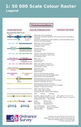
Chapter 2Legend1:50 000 Scale Colour Raster and Gazetteer technical specification chapter 2 v2.0.1 – 01/2008 © Crown copyright Page 18 of 33
1:50 000 Scale Colour Raster and Gazetteer technical specification chapter 2 v2.0.1 – 01/2008 © Crown copyright Page 19 of 33
1:50 000 Scale Colour Raster and Gazetteer technical specification chapter 2 v2.0.1 – 01/2008 © Crown copyright Page 20 of 33
1:50 000 Scale Colour Raster and Gazetteer technical specification chapter 2 v2.0.1 – 01/2008 © Crown copyright Page 21 of 33
Chapter 3GeoreferencingA definition for registering raster images within a geographic framework is the process of assigning mapcoordinates to the raster image data and resampling the pixels of the image to conform to the map projectiongrid. This allows tiles of map data to be located in their correct geographic position relative to the mapprojection and also to themselves.Great Britain is surveyed and mapped using the Transverse Mercator (or Gauss-Kruger) projection, so allraster tiles will be mapped to this projection as it applies to Ordnance Survey National Grid if using World orTAB files supplied by Ordnance Survey.Within the MIF record header the following information will be found under COORDSYS:CoordSys Earth Projection 8, 79, "m", -2, 49, 0.9996012717, 400000, -100000 Bounds(4.17232513428e-011, 7.7486038208e-011) (700000, 1300000)This information relates to the Transverse Mercator projection, its position relative to the rest of the world andalso an individual tile’s position relative to the projection. The record header is constructed as (not all fieldshave to be used):CoordSys Earth Projection 8The 8 relates to a MapInfo ® identifier, in this case the TransverseMercator projection.79 A MapInfo identifier, in this case this relates to Ordnance Survey ofGreat Britain 1936, Airy ellipsoid.“m”Relates to the unit of measurement, in this case metres.-2 This is the origin of the projection in respect of longitude.49 This is the origin of the projection in respect of latitude.0.9996012717 Indicates the distortion of the tile at the central meridian. A value of1.0 would indicate no distortion at all. However, distortion within thisprojection is minimal, even at the far western or eastern limits.400000, -100000 These figures indicate the false origin of the British National Grid.They represent the south-west corner of the Transverse Mercatorprojection, which overlays Great Britain, so all coordinates for anytile, no matter what scale, will always be positive.Bounds: (4.17232513428e-011, 7.7486038208e-011) These values represent the minimum bounding X and Y coordinatesfor the tile.(700000, 1300000) These values represent the maximum bounding X and Ycoordinates for the tile.1:50 000 Scale Colour Raster and Gazetteer technical specification chapter 3 v2.0.1 – 01/2008 © Crown copyright Page 22 of 33
Chapter 4Image file directory (TIFF)The image file directory for TIFF will contain a selection of the following entries:Tag 254 (NewSubfileType)An indication of the kind of data contained in this sub-file, for example, value = 0Tag 256 (ImageWidth)The number of columns in the image, the number of pixels per row, for example, value = 4000Tag 257 (ImageLength)The number of rows of pixels in the image, for example, value = 4000Tag 258 (BitsPerSample)Number of bits per component, for example, value = 8Tag 259 (Compression)Compression scheme used on the image data, for example, value = 5 (LZW)Tag 262 (Photo.Interpretation)The colour space of the image data, for example, value = 3 (RGB Palette).Tag 270 (ImageDescription)A string that describes the subject of the image, for example, value = 1:50 000 SU40Tag 273 (StripOffsets)For each strip, the byte offset of that strip, for example, 1st 4 values = 17833 20210 23238 26061Tag 278 (RowsPerStrip)The number of rows in each strip, for example, value = 2Tag 279 (StripByteCounts)For each strip, the number of bytes in that strip after compression, for example, 1st 4 values = 2377 30283823 2922Tag 282 (XResolution)The number of pixels per Resolution Unit in the Image Width, for example, value = 254/1Tag 283 (YResolution)The number of pixels per Resolution Unit in the Image Length, for example, value = 254/1Tag 296 (ResolutionUnit)Units used for Resolution, for example, value = 2 (Inch)Tag 306 (DateTime)Date and time of image creation, for example, value = 2006:06:30 12:38:41Tag 320 (ColourMap)Look-up table, for example, value = 1st 4 values = 55512 11308 51657 47288Tag 33432 (Copyright)Copyright notice, for example, value = ORDNANCE SURVEY CROWN COPYRIGHT 2007NOTE: The values given above are relevant to 1:50 000 scale TIFF data using LZW compression.1:50 000 Scale Colour Raster and Gazetteer technical specification chapter 4 v2.0.1 – 01/2008 © Crown copyright Page 23 of 33
TIFFColour image directory (TIFF)Tag number TIFF 8-bit uncompressed TIFF 8-bitLZW compressedFile Byte Order : MM (Big-endian) MM (Big-endian)Magic Number : 42 42Number of fields in IFD : 16 16NewSubfileType 254 0 0Image Width 256 4000 4000ImageLength 257 4000 4000BitsPerSample 258 8 8Compression 259 1(Uncompressed)5(LZW)Photo.Interpretation 262 3 (RGB Palette) 3 (RGB Palette)ImageDescription 270 1:50000 TILE SU40 1:50000 TILE SU40XResolution 282 254/1 254/1YResolution 283 254/1 254/1ResolutionUnit 296 2 (Inch) 2 (Inch)DateTime 306 2006:09:20 11:20:04 2006:09:20 11:20:04ColorMap 320 1st 4 values = 55512 1130851657 47288Copyright 33432 ORDNANCE SURVEYCROWN COPYRIGHT 20071st 4 values = 55512 1130851657 47288ORDNANCE SURVEYCROWN COPYRIGHT 2007The tag values listed in the above table are relevant to 1:50 000 scale Motorola TIFF raster data.It should be noted that customers can access tag information from a raster file image by right clicking on aTIFF data image and looking at properties, and then left clicking on summary.1:50 000 Scale Colour Raster and Gazetteer technical specification chapter 4 v2.0.1 – 01/2008 © Crown copyright Page 24 of 33
Annexe AGlossaryThe purpose of this chapter is to provide a glossary of terms used in the definition of products, services,licensing and other terms and conditions for 1:50 000 Scale Colour Raster and 1:50 000 Scale Gazetteer.American Standard Code for Information Interchange (ASCII)A standard binary coding system used to represent characters within a computer.binary digit (BIT)The smallest possible unit of data, resulting from a choice between 0 and 1.boundaryA boundary forms the division between two similar real-world objects, for example, property boundary oradministrative boundary, and is defined by one or more lines.byteA unit of computer storage of binary data, usually comprising 8 bits, equivalent to a character.characterA distinctive mark; an inscribed letter; one of a set of writing symbols.character codeThe binary representation of a single element of a character set; for example, EBCDIC, ASCII.coordinate pairA coordinate pair is an easting and a northing.coordinate transformationA computational process of converting an image or map from one coordinate system to another.compact discRead-only memory (CD-ROM). A data storage medium. A 12-cm disc similar to the audio CD. It is an alloydisc pitted with tiny holes and then coated in plastic. A laser head reads the pattern of the holes andtranslates them into binary data.copyrightThe sole legal right to print or publish a work. Crown Copyright subsists in all Ordnance Survey publicationsfor a 50-year period, from the end of the year in which they were first published, by virtue of the CopyrightDesigns and Patents Act 1988.customerAn organisation or individual that makes use of Ordnance Survey’s data supply facilities. This includes bothdirect sales customers of Ordnance Survey as well as customers of Licensed Partners. It does not includeanyone, or any organisation, that has access to Ordnance Survey material without charge.dataA representation of facts, concepts or instructions in a formalised manner suitable for communication,interpretation or processing.databaseAn organised, integrated collection of geographic data, which may or may not be spatial data. It is stored sothose specific applications can access the data by different logical paths. A database is accessed andmanaged by a database management system (software for managing database information).data formatA specification that defines the order in which data is stored or a description of the way data is held in a fileor record.data qualityAttributes of a dataset that define its suitability for a particular purpose, such as completeness, positionalaccuracy, currency and so on.1:50 000 Scale Colour Raster and Gazetteer technical specification annexe A v2.0.1 – 01/2008 © Crown copyright Page 25 of 33
data structureThe defined logical arrangement of data as used by a system for data management; a representation of adata model in computer form.data transfer mediumThis is the means by which computer files are transferred from one computer to another. Transfer mediamay be subdivided into communications media and physical media.datasetData as supplied in a particular format to customers, whether internal or external to Ordnance Survey.densityA measure of the number of units of data held on a stated length of storage surface. For example, somemagnetic tapes may be recorded at a density of 1 600 bits per inch (bpi). Often referred to as packingdensity.delivery mechanismThe method of supply of data to a customer (such as offline and online).descriptive nameA name describing a real-world object or feature (for example, School) as shown on the1:50 000 Scale Colour Raster map.definitive nameThe name as shown on the 1:50 000 Scale Colour Raster map.digitalData that is expressed as numbers (digits) in computer-readable form.digital updateThe supply of revised digital data to a customer at a predetermined interval of time.direct saleA direct transaction between Ordnance Survey and a customer.distinctive nameA text feature that forms a name that distinguishes it from other text features of the same type, for example,Millbrook School.dots per inch (dpi)The resolution, or fineness, of a raster image.eastingsSee rectangular coordinates.JPEGAn image named after the Joint Photographic Experts Group, it uses a lossy compression format. It isdesigned for compressing full colour or greyscale images of natural, real-world scenes and works well onphotographs. It is the de facto standard for photographs on the web.encodingThe process of converting information to a computer-readable form, for example, digitising maps.featureA geographic entity such as a building or stream, either taken from a map or surveyed directly from the realworld. Can be a point/symbol, text or line.formatThe specified arrangement of data, for example, the layout of a printed document, the arrangement of theparts of a computer instruction, the arrangement of data in a record.1:50 000 Scale Colour Raster and Gazetteer technical specification annexe A v2.0.1 – 01/2008 © Crown copyright Page 26 of 33
generalisationThe cartographic process of simplifying the depiction of features to fit the output scale. For example, roadwidening is necessary at smaller scales to enhance their visibility.geocodeAssigning a geographic location to data, for example, adding coordinates to an address.geographic coordinatesCoordinates, usually expressed as latitudes and longitudes, which define position on the Earth's surface.georeferenceA definition for registering raster images within a geographic framework is the process of assigning mapcoordinates to the raster image data and resampling the pixels of the image to conform to the map projectiongrid.gigabyte (Gb)1 073 741 824 bytes, a measure of data storage capacity (see megabyte).kilobyte (Kb)1 024 bytes, a measure of data storage capacity.Licensed PartnerAny organisation that has entered into a formal licence agreement with Ordnance Survey to market mapinformation or to incorporate map data with their application or service.linear featureMap feature in the form of a line (for example, river, and boundary) that may or may not represent areal-world (existent) feature.local originThe local origin of rectangular coordinates is the south-west corner of the 1 km by 1 km National Grid squarethey identify.Map scaleThe ratio between the extent of a feature on the map and its extent on the ground, normally expressed as arepresentative fraction, for example, 1:1250, 1:50 000 and so on.megabyte (Mb)1 048 576 bytes, a measure of data storage capacity (see gigabyte).National GridThe metric grid on the Transverse Mercator projection used by Ordnance Survey on all post-Second WorldWar mapping to provide an unambiguous spatial reference in Great Britain for any place or entity, whateverthe map scale.northingsSee rectangular coordinates.Oracle ®The relational database management system used for the 1:50 000 Scale Gazetteer.originThe zero point in a system of rectangular coordinates.pixelIn the 1:50 000 scale product a pixel is a single point represented by a square.pointsA pair of coordinates.raster dataAttribute data expressed as an array of pixels, with spatial position implicit in the ordering of the pixels.1:50 000 Scale Colour Raster and Gazetteer technical specification annexe A v2.0.1 – 01/2008 © Crown copyright Page 27 of 33
eal-world objectThe real-world feature represented by a feature, for example, a building, a fence, a wood.rectangular coordinatesAlso known as x-y coordinates and as eastings and northings. These are two-dimensional coordinates thatmeasure the position of any point relative to an arbitrary origin on a plane surface (for example, a mapprojection, a digitising table or a VDU screen).stippleUsed to produce light or dark shading (for example, building /water fill); this is dependent on spacing of thedots – the denser the dots, the darker the effect.stringA set of items that can be arranged into a sequence according to a rule.supply formatThe file format in which the data is supplied to the customer.tagTags are unique numbers that are used for identifying specific information in TIFF files, for example, imagewidth, image length, bits per sample, photo interpretation and resolution.terminatorCharacter, or character string, or field, or record used to signal the end of a record, or section, or volume ordatabase.tileA unit of map used to divide large areas into regular and more manageable sizes.TIFFTIFF is a tagged image file format-based file format for storing and interchanging raster images with the mostrecent version (6.0) published in 1992.transfer formatThe format used to transfer data between computer systems. In general usage this can refer not only to theorganisation of data but also to the associated information, such as attribute codes, which are required inorder to successfully complete the transfer.transfer mediumThe physical medium on which digital data is transferred from one computer system to another. For example,compact disc.UNIX ®An operating system that supports multitasking and is used by many workstations and mini computers.updateThe process of adding to and revising existing digital map data to take account of change.volumeA physical unit of the transfer medium such as a single disk or a single DVD.1:50 000 Scale Colour Raster and Gazetteer technical specification annexe A v2.0.1 – 01/2008 © Crown copyright Page 28 of 33
Annexe B1:50 000 Scale Gazetteer county code listA full list of all the county codes in fields 12 (CO_CODE), 13 (COUNTY) and 14 (FULL_COUNTY) is below:CO_CODE COUNTY FULL_COUNTYAB Aberd AberdeenshireAG Angus AngusAN C of Aber Aberdeen CityAR Arg & Bt Argyll and ButeBA Brad BradfordBB Black w Dar Blackburn with DarwenBC Brackn Bracknell ForestBD Bark & Dag Barking & DagenhamBE Brig BridgendBF Beds BedfordshireBG Blae Gw Blaenau GwentBH C of Bri & Hov City of Brighton and HoveBI Birm BirminghamBL Barns BarnsleyBM Bucks BuckinghamshireBN Barnet BarnetBO Bolton BoltonBP Blackp BlackpoolBR Brom BromleyBS Bath & NE Somer Bath and North East SomersetBT Brent BrentBU Bourne BournemouthBX Bexley BexleyBY Bury BuryBZ C of Bris City of BristolCA Cald CalderdaleCB Cambs CambridgeshireCD Card CardiffCE Cered CeredigionCF Caer CaerphillyCH Ches CheshireCL Clackm ClackmannanshireCM Camden CamdenCN Corn CornwallCT Carm CarmarthenshireCU Cumbr CumbriaCV Cov CoventryCW Conwy ConwyCY Croy CroydonDB C of Derb City of DerbyDD C of Dun Dundee CityDE Denb DenbighshireDG D & G Dumfries and GallowayDL Darl DarlingtonDN Devon DevonDR Donc DoncasterDT Dorset DorsetDU Durham DurhamDY Derby Derbyshire1:50 000 Scale Colour Raster and Gazetteer technical specification annexe B v2.0.1 – 01/2008 © Crown copyright Page 29 of 33
CO_CODE COUNTY FULL_COUNTYDZ Dudley DudleyEA E Ayr East AyrshireEB C of Edin City of EdinburghED E Dunb East DunbartonshireEG Ealing EalingEL E Loth East LothianEN Enf EnfieldER E Renf East RenfrewshireES E Susx East SussexEX Essex EssexEY E Yorks East Riding of YorkshireFA Falk FalkirkFF Fife FifeFL Flint FlintshireGH Ghead GatesheadGL C of Glas Glasgow CityGR Glos GloucestershireGW Gren GreenwichGY Gwyn GwyneddHA Halton HaltonHD Herts HertfordshireHE Heref HerefordshireHF Ham & Ful Hammersmith & FulhamHG Hargy HaringeyHI Hill HillingdonHL Highld HighlandHN Hack HackneyHP Hants HampshireHR Harrow HarrowHS Houns HounslowHT Hartpl HartlepoolHV Hav HaveringIA I of Angl Isle of AngleseyIL Isling IslingtonIM I of M Isle of ManIN Inverc InverclydeIS I Scilly Isles of ScillyIV C of Inv City of InvernessIW I of W Isle of WightKC Ken & Ch Royal Borough of Kensington & ChelseaKG King Kingston upon ThamesKH C of K upon H City of Kingston upon HullKL Kirk KirkleesKN Know KnowsleyKT Kent KentLA Lancs LancashireLB Lam LambethLC C of Leic City of LeicesterLD Leeds LeedsLL Lincs LincolnshireLN Luton LutonLO C of Lon City of LondonLP Liv Liverpool1:50 000 Scale Colour Raster and Gazetteer technical specification annexe B v2.0.1 – 01/2008 © Crown copyright Page 30 of 33
CO_CODE COUNTY FULL_COUNTYLS Lew LewishamLT Leic LeicestershireMA Man ManchesterMB Midd MiddlesbroughME Medway MedwayMI Midlo MidlothianMK Mil Key Milton KeynesMM Monm MonmouthshireMO Moray MorayMR Merton MertonMT Merth Tyd Merthyr TydfilNA N Ayr North AyrshireNC NE Lincs North East LincolnshireND Northum NorthumberlandNE Newp NewportNG C of Nott City of NottinghamNH Newham NewhamNI N Lincs North LincolnshireNK Norf NorfolkNL N Lanak North LanarkshireNN Northnts NorthamptonshireNP Nth Pt Talb Neath Port TalbotNR N Tyne North TynesideNS N Som North SomersetNT Notts NottinghamshireNW N upon Ty Newcastle upon TyneNY N Yks North YorkshireOH Oldham OldhamOK Orkney Orkney IslandsON Oxon OxfordshirePB Pemb PembrokeshirePE C of Peterb City of PeterboroughPK Pth & Kin Perth and KinrossPL Poole PoolePO C of Port City of PortsmouthPW Powys PowysPY C of Plym City of PlymouthRB Redbr RedbridgeRC Red & Cl Redcar & ClevelandRD Roch RochdaleRE Renf RenfrewshireRG Read ReadingRH Rho Cyn Taf Rhondda, Cynon, TaffRL Rut RutlandRO Roth RotherhamRT Rich Richmond upon ThamesSA Sand SandwellSB Scot Bord Scottish BordersSC Salf SalfordSD Swin SwindonSE Sefton SeftonSF Staffs StaffordshireSG S Glos South Gloucestershire1:50 000 Scale Colour Raster and Gazetteer technical specification annexe B v2.0.1 – 01/2008 © Crown copyright Page 31 of 33
CO_CODE COUNTY FULL_COUNTYSH Shrops ShropshireSI Shetld Shetland IslandsSJ C of Stoke City of Stoke-on-TrentSK Suff SuffolkSL S Lanak South LanarkshireSM Stock on T Stockton on TeesSN St Hel St HelensSO C of Soton City of SouthamptonSP Sheff SheffieldSQ Sol SolihullSR Stir StirlingSS Swan SwanseaST Somer SomersetSU Surrey SurreySV Sund SunderlandSW Sthwk SouthwarkSX S Ayr South AyrshireSY S Tyne South TynesideSZ Sutton SuttonTB Torbay TorbayTF Torf TorfaenTH T Ham Tower HamletsTR Traf TraffordTS Tames TamesideTU Thurr ThurrockVG V of Glam The Vale of GlamorganWA Wals WalsallWB W Berks West BerkshireWC Win & Maid Windsor and MaidenheadWD W Dunb West DunbartonshireWE Wakf WakefieldWF Wal F Waltham ForestWG Warr WarringtonWH C of Wolv City of WolverhamptonWI N Eil Na h-Eileanan an IarWJ Wok WokinghamWK Warw WarwickshireWL W Loth West LothianWM C of West City of WestminsterWN Wigan WiganWO Worcs WorcestershireWP Wrekin Telford and WrekinWR Wirral WirralWS W Susx West SussexWT Wilts WiltshireWW Wan WandsworthWX Wrex WrexhamYK York YorkYS Sou-on-Sea Southend-on-SeaYT Slough SloughYY Stock Stockport1:50 000 Scale Colour Raster and Gazetteer technical specification annexe B v2.0.1 – 01/2008 © Crown copyright Page 32 of 33
Annexe C1:50 000 Scale Gazetteer feature code listFeaturecodeAFFMHRCTOWDescriptionNon-Roman antiquity: shown on the OS Landranger Map in Lutheran type.Forest or wood: named areas on the OS Landranger Map identified by a green colour fill.Farm: all buildings named on the OS Landranger Map with the text string 'Farm' or 'Fm' aspart of their name. These features can include private houses that include 'Farm' as part oftheir name.NOTE: not all farms shown on OS Landranger Maps are covered under this classification astheir names, especially in Wales, do not contain the word 'Farm'.Large hill features or mountains with a minimum height difference of 30 m (three ringcontours): hills are only named where their name has been selected for depiction on theOS Landranger Map and the feature contains three contour lines. If less than three contourlines are present classification 'X' is used. Spurs, saddles and slopes are not classified.Roman antiquity: shown on the OS Landranger Map in Spartan antiquity type.CityTownOther settlements (urban area, village: Place names relating to built-up areas as shown on theOS Landranger Map).Water features: rivers, lakes, lochs, reservoirs and other water features, including coastalwaters shown in blue type on OS Landranger Maps, except marsh, which is recorded underclassification 'X'.X: Other feature: all distinctive names not covered by the above classifications, for example,private houses, isolated buildings, airports, commons, greens, marshes.1:50 000 Scale Colour Raster and Gazetteer technical specification annexe C v2.0.1 – 01/2008 © Crown copyright Page 33 of 33