User Guide - Digimap
User Guide - Digimap
User Guide - Digimap
- No tags were found...
You also want an ePaper? Increase the reach of your titles
YUMPU automatically turns print PDFs into web optimized ePapers that Google loves.
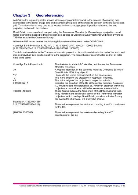
Chapter 3GeoreferencingA definition for registering raster images within a geographic framework is the process of assigning mapcoordinates to the raster image data and resampling the pixels of the image to conform to the map projectiongrid. This allows tiles of map data to be located in their correct geographic position relative to the mapprojection and also to themselves.Great Britain is surveyed and mapped using the Transverse Mercator (or Gauss-Kruger) projection, so allraster tiles will be mapped to this projection as it applies to Ordnance Survey National Grid if using World orTAB files supplied by Ordnance Survey.Within the MIF record header the following information will be found under COORDSYS:CoordSys Earth Projection 8, 79, "m", -2, 49, 0.9996012717, 400000, -100000 Bounds(4.17232513428e-011, 7.7486038208e-011) (700000, 1300000)This information relates to the Transverse Mercator projection, its position relative to the rest of the world andalso an individual tile’s position relative to the projection. The record header is constructed as (not all fieldshave to be used):CoordSys Earth Projection 8The 8 relates to a MapInfo ® identifier, in this case the TransverseMercator projection.79 A MapInfo identifier, in this case this relates to Ordnance Survey ofGreat Britain 1936, Airy ellipsoid.“m”Relates to the unit of measurement, in this case metres.-2 This is the origin of the projection in respect of longitude.49 This is the origin of the projection in respect of latitude.0.9996012717 Indicates the distortion of the tile at the central meridian. A value of1.0 would indicate no distortion at all. However, distortion within thisprojection is minimal, even at the far western or eastern limits.400000, -100000 These figures indicate the false origin of the British National Grid.They represent the south-west corner of the Transverse Mercatorprojection, which overlays Great Britain, so all coordinates for anytile, no matter what scale, will always be positive.Bounds: (4.17232513428e-011, 7.7486038208e-011) These values represent the minimum bounding X and Y coordinatesfor the tile.(700000, 1300000) These values represent the maximum bounding X and Ycoordinates for the tile.1:50 000 Scale Colour Raster and Gazetteer technical specification chapter 3 v2.0.1 – 01/2008 © Crown copyright Page 22 of 33


