User Guide - Digimap
User Guide - Digimap
User Guide - Digimap
- No tags were found...

You also want an ePaper? Increase the reach of your titles
YUMPU automatically turns print PDFs into web optimized ePapers that Google loves.
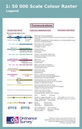
Chapter 2Content1:50 000 Scale Colour Raster1:50 000 Scale Colour Raster shows the following features:• building blocks and important buildings;• roads, public rights of way, cycle networks, paths, tracks;• vegetation type, Forestry Commission access land, National Trust land;• water features and associated detail;• railways and associated detail;• height information;• archaeological and antiquity information;• administrative boundary information;• text;• tourist information – including camping/caravan sites, gardens, golf courses, information centres, naturereserves, car parks, picnic sites, viewpoints and youth hostels; and• rock features.1:50 000 Scale Gazetteer1:50 000 Scale Gazetteer includes records for the following feature types:• cities;• towns;• water features;• forests or woods;• farms*;• antiquities;• hills or mountains; and• other features, including those distinctive names not covered by the above classifications, for example,private houses, isolated buildings, airports, commons, greens and marshes.* Farms that do not contain the word ‘farm’ as part of the name will not be identified under this feature type;they will be listed as other.1:50 000 Scale Colour Raster and Gazetteer user guide chapter 2 v2.0.1 – 01/2008 © Crown copyright Page 7 of 33