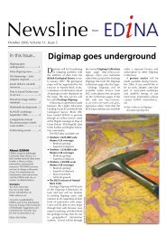
User Guide - Digimap
User Guide - Digimap
User Guide - Digimap
- No tags were found...

Create successful ePaper yourself
Turn your PDF publications into a flip-book with our unique Google optimized e-Paper software.
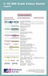
Chapter 1Introduction1:50 000 Scale Colour Raster1:50 000 Scale Colour Raster is a mid-scale product in Ordnance Survey’s raster portfolio, providing a rasterimage of the popular OS Landranger Map series. 1:50 000 Scale Colour Raster is available in colour and ina number of file formats. An example of the data is shown in figure 1 below.Figure 1: an extract of 1:50 000 Scale Colour Raster1:50 000 Scale Colour Raster provides an image where the detail has been converted to a grid of pixels,which can then be displayed on computer screens. The product covers all of Great Britain and is supplied astiles aligned to the National Grid. Data is converted into a raster format at a resolution of 254 dots per inch(dpi) and a pixel is equivalent to 5 metres on the ground. This resolution has been chosen as it maintains thenecessary clarity for text shown on the map.The product can be overlaid with other Ordnance Survey products or a customer’s own geographic/businessdata, besides providing a detailed geographic context in its own right.1:50 000 Scale Colour Raster is produced to provide customers with a detailed product that could be madeavailable in a number of different formats to provide either a map of an area when used on its own or as ameans of providing geographic context to help a customer visualise their own data.1:50 000 Scale Colour Raster is supplied as graphic image files that can easily be read by many imagesoftware packages. To view tiles in geographic relation to each other and to create the best context for itsuse with other Ordnance Survey or third-party data, it is recommended that it is used in a geographicalinformation system (GIS).As can be seen from the illustration above, the product provides an excellent overview of the main featuresand communication routes of an area, and this makes 1:50 000 Scale Colour Raster particularly useful fordevelopment and land-use planning, environmental impact analysis, vehicle routing, asset management,marketing analysis, and display and promotion purposes.1:50 000 Scale Gazetteer1:50 000 Scale Gazetteer is a list of distinctive place or feature names from 1:50 000 Scale Colour Raster,with location information. This enables you to easily locate places on the map, geocode your data and buildsearch functionality into applications.1:50 000 Scale Gazetteer contains entries for airports, farms, hills, woodlands, commons and other places,including over 42 000 cities, towns and settlements with coordinates to 1-km resolution.1:50 000 Scale Colour Raster and Gazetteer user guide chapter 1 v2.0.1 – 01/2008 © Crown copyright Page 5 of 33