Penkhull Village Conservation Area Appraisal - Stoke-on-Trent City ...
Penkhull Village Conservation Area Appraisal - Stoke-on-Trent City ...
Penkhull Village Conservation Area Appraisal - Stoke-on-Trent City ...
- No tags were found...
You also want an ePaper? Increase the reach of your titles
YUMPU automatically turns print PDFs into web optimized ePapers that Google loves.
3. History and Archaeology3.1 <str<strong>on</strong>g>Penkhull</str<strong>on</strong>g> may well be the first inhabited settlement within <str<strong>on</strong>g>Stoke</str<strong>on</strong>g>-<strong>on</strong>-<strong>Trent</strong> as it has held asettlement for over four thousand years. It was ideally situated due to its woodedhunting grounds, clear views over the surrounding areas to east and west, and itslocality to two streams at Lyme Valley and <strong>Trent</strong> Valley. It is likely that the village beganas a hill-fort.3.2 At the time of the Domesday book <str<strong>on</strong>g>Penkhull</str<strong>on</strong>g> c<strong>on</strong>sisted of over 1,000 acres of landstretching into what is now Newcastle-under-Lyme, Hanley, Shelt<strong>on</strong>, <str<strong>on</strong>g>Stoke</str<strong>on</strong>g> andBoothen. At this time the main centre of populati<strong>on</strong> in <str<strong>on</strong>g>Stoke</str<strong>on</strong>g>-up<strong>on</strong>-<strong>Trent</strong> was round<str<strong>on</strong>g>Penkhull</str<strong>on</strong>g> village; <str<strong>on</strong>g>Stoke</str<strong>on</strong>g> itself had little more than the parish church. The decline of<str<strong>on</strong>g>Penkhull</str<strong>on</strong>g> began so<strong>on</strong> after with the c<strong>on</strong>structi<strong>on</strong> of a New Castle nearby and theinevitable introducti<strong>on</strong> of a market town (becoming Newcastle-under-Lyme) in the late12 th century, and furthermore with the development of <str<strong>on</strong>g>Stoke</str<strong>on</strong>g> town in the 19 th century.3.3 From the late 16 th century, the Manor of Newcastle-under-Lyme’s courts were held at<str<strong>on</strong>g>Penkhull</str<strong>on</strong>g>. So<strong>on</strong> after the courthouse formed a part of what is now the Greyhound Inn,built in 1612. From 1635 to 1817 all the manorial courts were held at <str<strong>on</strong>g>Penkhull</str<strong>on</strong>g>.3.4 By the 17 th century the <str<strong>on</strong>g>Penkhull</str<strong>on</strong>g>-Boothen area was grouped for purposes of parishgovernment with Clayt<strong>on</strong> and Seabridge to form <strong>on</strong>e of the four quarters of the ancientparish of <str<strong>on</strong>g>Stoke</str<strong>on</strong>g>-up<strong>on</strong>-<strong>Trent</strong>. Manorially the area was part of the Newcastle Manor.3.5 <str<strong>on</strong>g>Penkhull</str<strong>on</strong>g> had a windmill dating from approximately 1780 which stood <strong>on</strong> the presentKirkland Lane, formerly known as Mill Street. It was c<strong>on</strong>structed to serve local farmerswho needed somewhere for milling. <str<strong>on</strong>g>Penkhull</str<strong>on</strong>g> also began producing ware in the mid tolate seventeenth century with some of the first potteries in the district.3.6 In the late 18 th and early 19 th centuries <str<strong>on</strong>g>Penkhull</str<strong>on</strong>g> village was transformed largely as aresult of the growth of the adjacent town of <str<strong>on</strong>g>Stoke</str<strong>on</strong>g>. During that period the centre of thevillage was built up with new terraced houses which largely replaced the medievalcottages. A leading role in this development was played by Josiah Spode II who wasresp<strong>on</strong>sible for the c<strong>on</strong>structi<strong>on</strong> of a new road from the village to <str<strong>on</strong>g>Stoke</str<strong>on</strong>g> (what is now<str<strong>on</strong>g>Penkhull</str<strong>on</strong>g> New Road). Spode learnt his trade in L<strong>on</strong>d<strong>on</strong>, but returned to <str<strong>on</strong>g>Stoke</str<strong>on</strong>g> in 1797after the death of his father to take over the running of the pottery business. He builtcottages for workers which survived until the mid 1960’s. Perhaps his most famousdevelopment was the building of <str<strong>on</strong>g>Penkhull</str<strong>on</strong>g> Square <strong>on</strong> the south side of the village,c<strong>on</strong>taining 20 houses and built in about 1802-3. Spode also bought 17 acres of landnorth of the village of <str<strong>on</strong>g>Penkhull</str<strong>on</strong>g>, occupied by an old farmhouse which was thendemolished, and built a new mansi<strong>on</strong> house called “The Mount” c. 1803-4. It was thebiggest mansi<strong>on</strong> ever built in <str<strong>on</strong>g>Stoke</str<strong>on</strong>g>; prior to this most factory owners resided in a house<strong>on</strong> the factory site.3.7 In 1842 St Thomas’ Church was built to replace a religious school <strong>on</strong> the open space inthe centre of the village known as <str<strong>on</strong>g>Penkhull</str<strong>on</strong>g> Green. The Church was designed in adistinctive Early English style situated in an oval shaped churchyard c<strong>on</strong>taining manymature trees. Like Hartshill church, it was designed by George Gilbert Scott. However,due to a shortage of m<strong>on</strong>ey it was a much plainer structure built with poorer qualityst<strong>on</strong>e.7
3.8 With the c<strong>on</strong>structi<strong>on</strong> of the church, a new school was built <strong>on</strong> a plot of land adjacent toit <strong>on</strong> the <str<strong>on</strong>g>Village</str<strong>on</strong>g> Green. Yet this was found to be poorly situated with regards to thechurch, and as such was removed. The Sunday school was also struggling toaccommodate its growing attendance. In 1845 a new school was built a short distanceaway, designed by George Lynam and partly funded by Rev T Mint<strong>on</strong>, he the s<strong>on</strong> of thefounder of Mint<strong>on</strong> Pottery. The school remains as the hall today at the top of <strong>Trent</strong>Valley Road.3.9 Adjacent to the <str<strong>on</strong>g>C<strong>on</strong>servati<strong>on</strong></str<strong>on</strong>g> <str<strong>on</strong>g>Area</str<strong>on</strong>g> is <str<strong>on</strong>g>Penkhull</str<strong>on</strong>g> Garden <str<strong>on</strong>g>Village</str<strong>on</strong>g>. Its origins are fromideas put forward in the late 19 th century by Ebenezer Howard, when he proposed thebuilding of new cities <strong>on</strong> previously undeveloped agricultural land. The main objectivewas the provisi<strong>on</strong> of healthy surroundings for industrial workers by physically separatingthe workers’ housing from their place of work and as such raising the standard of healthand comfort for all workers by combining town and country life. Working c<strong>on</strong>diti<strong>on</strong>s inthe pottery industry were arduous. <str<strong>on</strong>g>Stoke</str<strong>on</strong>g>-<strong>on</strong>-<strong>Trent</strong> Tenants Limited purchased 38 acresof land in 1910, and the <str<strong>on</strong>g>Penkhull</str<strong>on</strong>g> scheme was intended to be the first of four Garden<str<strong>on</strong>g>Village</str<strong>on</strong>g>s for <str<strong>on</strong>g>Stoke</str<strong>on</strong>g>-<strong>on</strong>-<strong>Trent</strong>. The architects of the estate sought to create a rustic settingin stark c<strong>on</strong>trast to the rest of the city. The 250 houses were c<strong>on</strong>structed in separateclusters, with a limit of 10 houses per acre (as opposed to the usual 40 per acreassociated with terraced housing). The estate was formed and built between 1910 and1914. During the c<strong>on</strong>structi<strong>on</strong> there were some interesting archaeological finds,including a small incense cup bel<strong>on</strong>ging to the Middle Br<strong>on</strong>ze Age, circa 1800 B.C. It islikely that the Romans would have placed an outpost at <str<strong>on</strong>g>Penkhull</str<strong>on</strong>g> due to the extensiveviews from the hill.3.10 The street pattern in <str<strong>on</strong>g>Penkhull</str<strong>on</strong>g> village has remained almost totally unchanged for thepast 100 years. However, many of the streets surrounding the church have changedname.FIGURE 1: Map of 1880 <strong>on</strong> the left and a current map <strong>on</strong> the right showing how the area hasretained its form8
4.2 Views4.21 Few significant internal views, alignments and relati<strong>on</strong>ships can be identified:• The church is an important element of the <str<strong>on</strong>g>C<strong>on</strong>servati<strong>on</strong></str<strong>on</strong>g> <str<strong>on</strong>g>Area</str<strong>on</strong>g> as it is highly visibletowering over the treetops creating an important core area. There are no other tallbuildings in the area.• The narrower lanes of D<strong>on</strong>caster Lane and Garden Street create a rural village feeland bring an element of surprise to the <str<strong>on</strong>g>C<strong>on</strong>servati<strong>on</strong></str<strong>on</strong>g> <str<strong>on</strong>g>Area</str<strong>on</strong>g>.FIGURE 4: The Core area showing the importance of the churchFIGURE 5: The curved narrow lanes lending a secretive element and an element of surprise tothe <str<strong>on</strong>g>C<strong>on</strong>servati<strong>on</strong></str<strong>on</strong>g> <str<strong>on</strong>g>Area</str<strong>on</strong>g>11
4.22 Views of quality out of the <str<strong>on</strong>g>C<strong>on</strong>servati<strong>on</strong></str<strong>on</strong>g> <str<strong>on</strong>g>Area</str<strong>on</strong>g> are limited.• L<strong>on</strong>g views of both the city of <str<strong>on</strong>g>Stoke</str<strong>on</strong>g>-<strong>on</strong>-<strong>Trent</strong> and the town of Newcastle-under-Lymeare visible from this hilltop locati<strong>on</strong>.FIGURE 6: The view towards the East with Fent<strong>on</strong> Church in the centre12
4.3 Open Spaces4.31 The <str<strong>on</strong>g>C<strong>on</strong>servati<strong>on</strong></str<strong>on</strong>g> <str<strong>on</strong>g>Area</str<strong>on</strong>g> has few green spaces.• The former graveyard and now greenspace in fr<strong>on</strong>t of the church is the <strong>on</strong>ly publicgreen space within the <str<strong>on</strong>g>C<strong>on</strong>servati<strong>on</strong></str<strong>on</strong>g> <str<strong>on</strong>g>Area</str<strong>on</strong>g>.FIGURE 7: Central greenspace creating a village feel in the <str<strong>on</strong>g>C<strong>on</strong>servati<strong>on</strong></str<strong>on</strong>g> <str<strong>on</strong>g>Area</str<strong>on</strong>g>• The area adjacent to <str<strong>on</strong>g>Penkhull</str<strong>on</strong>g> Farm and Elm Tree House remains as fields withoutpublic access.• The main public greenspace near to the <str<strong>on</strong>g>C<strong>on</strong>servati<strong>on</strong></str<strong>on</strong>g> <str<strong>on</strong>g>Area</str<strong>on</strong>g> is that adjacent to thehigh school al<strong>on</strong>g the boundary of the Garden <str<strong>on</strong>g>Village</str<strong>on</strong>g> estate.13
5. Built Form5.1 The Influence of Use Patterns and Patr<strong>on</strong>age5.12 The historical development of the area is still clearly in evidence in the street form.5.13 Josiah Spode II played a role in the development of the area by funding a road toc<strong>on</strong>nect the village with the town of <str<strong>on</strong>g>Stoke</str<strong>on</strong>g> and by building his home, the Mount, which isadjacent to the <str<strong>on</strong>g>C<strong>on</strong>servati<strong>on</strong></str<strong>on</strong>g> <str<strong>on</strong>g>Area</str<strong>on</strong>g>.5.14 <str<strong>on</strong>g>Penkhull</str<strong>on</strong>g> developed differently to the other areas of the city by not having an individualbenefactor to fund public facilities as many other parts of the city did.5.15 <str<strong>on</strong>g>Penkhull</str<strong>on</strong>g> retains it village feel despite being within the city of <str<strong>on</strong>g>Stoke</str<strong>on</strong>g>-<strong>on</strong>-<strong>Trent</strong>. This ispartially due to the lack of community architecture and the vernacular development ofthe area.FIGURE 8: Greenery also creates the village and rural feel to the area5.16 The Church of the St Thomas the Apostle is a landmark within the <str<strong>on</strong>g>C<strong>on</strong>servati<strong>on</strong></str<strong>on</strong>g> <str<strong>on</strong>g>Area</str<strong>on</strong>g>and can be seen for miles around <strong>on</strong> the hilltop.14
5.2 Architectural Character, Materials, Colours and Textures5.21 StyleThe <str<strong>on</strong>g>C<strong>on</strong>servati<strong>on</strong></str<strong>on</strong>g> <str<strong>on</strong>g>Area</str<strong>on</strong>g> is has an eclectic mix of styles which reflect the village’s l<strong>on</strong>ghistory. These range from the larger older traditi<strong>on</strong>al detached houses to 1970’sterraced housing. Larger gentlemen’s dwellings reside al<strong>on</strong>gside workers cottages.The Core of the <str<strong>on</strong>g>C<strong>on</strong>servati<strong>on</strong></str<strong>on</strong>g> <str<strong>on</strong>g>Area</str<strong>on</strong>g> is dominated by the church and by the 1970’sstaggered terrace housing <strong>on</strong> the East side and also by mature trees and st<strong>on</strong>e or brickwalls.5.22 Plan, Form and MassingThere is a wide variety of structures within the <str<strong>on</strong>g>C<strong>on</strong>servati<strong>on</strong></str<strong>on</strong>g> <str<strong>on</strong>g>Area</str<strong>on</strong>g>, from the staggeredterraced housing to the larger semi and detached houses al<strong>on</strong>g D<strong>on</strong>caster lane.Typically all the housing has both fr<strong>on</strong>t and rear gardens with the larger properties setwithin their own land.The properties al<strong>on</strong>g the Manor Court Street are of mixed plan but are generallygrouped together to form distinct masses.FIGURE 9: Scales and massing: the simple character of the shops c<strong>on</strong>trasting with thecomplicated design of the Greyhound Inn and the church15
5.23 External Walls and Façade FinishesBrickwork - TilesRed facing brick laid in Running or Flemish b<strong>on</strong>d is the comm<strong>on</strong> façade material acrossthe <str<strong>on</strong>g>C<strong>on</strong>servati<strong>on</strong></str<strong>on</strong>g> <str<strong>on</strong>g>Area</str<strong>on</strong>g> and particularly so within the Core area. Some brick walls arevisible throughout the <str<strong>on</strong>g>C<strong>on</strong>servati<strong>on</strong></str<strong>on</strong>g> <str<strong>on</strong>g>Area</str<strong>on</strong>g>; most brick walls are not dwarf andincorporate large gateposts. Brickwork is characteristically plain in detailing within thearea with the excepti<strong>on</strong> of the Marquis of Granby and Elm Tree House. The Marquis ofGranby has terracotta embossed tiles over the ground floor windows and Elm TreeHouse has two bands of projecting brick and tile ‘skirts’ wrapping round the buildingand red brick diaperwork crosses c<strong>on</strong>trasting with the Staffordshire blue brick.FIGURE 10: The <str<strong>on</strong>g>C<strong>on</strong>servati<strong>on</strong></str<strong>on</strong>g> <str<strong>on</strong>g>Area</str<strong>on</strong>g> is characterised by plain buildings with simpledetailsThe 1970’s housing in Rothwell Street has buff facing brick and this brick also appears<strong>on</strong> the detailing of the new houses in Thomas Ward Place.St<strong>on</strong>eworkThe use of st<strong>on</strong>e within the <str<strong>on</strong>g>C<strong>on</strong>servati<strong>on</strong></str<strong>on</strong>g> <str<strong>on</strong>g>Area</str<strong>on</strong>g> is mostly restricted to detailing <strong>on</strong>buildings, with the excepti<strong>on</strong> of the Church of St Thomas the Apostle. The coursed andsquared local Red Hollingt<strong>on</strong> sandst<strong>on</strong>e church is surrounded by a dwarf st<strong>on</strong>e wall.Local red Hollingt<strong>on</strong> st<strong>on</strong>ework is also in evidence in walls, such as those in GardenStreet, and <strong>on</strong> window surrounds throughout the <str<strong>on</strong>g>C<strong>on</strong>servati<strong>on</strong></str<strong>on</strong>g> <str<strong>on</strong>g>Area</str<strong>on</strong>g>.Façade TreatmentsGenerally the buildings in the <str<strong>on</strong>g>C<strong>on</strong>servati<strong>on</strong></str<strong>on</strong>g> <str<strong>on</strong>g>Area</str<strong>on</strong>g> are split between brick facades andrendered facades. Tile hanging is also comm<strong>on</strong> throughout the area.16
FIGURE 11: The 1970’s housing today, showing a comm<strong>on</strong> uniformityC<strong>on</strong>creteNowhere used extensively.5.24 Roofs• MaterialVirtually all of the older properties carry local dark blue-purple roof tiles. Roofs in thearea carry simple roof and ridge tiles with no decorati<strong>on</strong> or detailing. Therefore theGreyhound Inn is distinctive in the use of round tiles and simple square finials. Plaindesigned deep eaves are a feature of the <str<strong>on</strong>g>C<strong>on</strong>servati<strong>on</strong></str<strong>on</strong>g> <str<strong>on</strong>g>Area</str<strong>on</strong>g> and many chimneyshave been retained.FIGURE 12: The simple decorative detailing <strong>on</strong> the Greyhound Inn c<strong>on</strong>trasting with theplainness of the other roofs within the <str<strong>on</strong>g>C<strong>on</strong>servati<strong>on</strong></str<strong>on</strong>g> <str<strong>on</strong>g>Area</str<strong>on</strong>g>• Pitch and TypeThe majority of the houses within the <str<strong>on</strong>g>C<strong>on</strong>servati<strong>on</strong></str<strong>on</strong>g> <str<strong>on</strong>g>Area</str<strong>on</strong>g> carry gabled pitched roofs.The 1970’s housing in Rothwell Street is distinctive by its use of duel pitched roofswhich span from party wall to party wall and give the impressi<strong>on</strong> of being m<strong>on</strong>opitched.17
Dutch gables are a feature of the <str<strong>on</strong>g>C<strong>on</strong>servati<strong>on</strong></str<strong>on</strong>g> <str<strong>on</strong>g>Area</str<strong>on</strong>g> and are visible <strong>on</strong> the Marquis ofGranby and the Vicarage in D<strong>on</strong>caster Lane. The Greyhound Inn has full dormerwindows <strong>on</strong> a gable roof facing towards the church, topped with finials. The Church ofSt Thomas has an unusual row of mid sloped dormers <strong>on</strong> both sides of the nave. No 2Thomas Ward Place in unique within the <str<strong>on</strong>g>C<strong>on</strong>servati<strong>on</strong></str<strong>on</strong>g> <str<strong>on</strong>g>Area</str<strong>on</strong>g> by used of a hipped roof,as is The Views with a double span gable roof.FIGURE 13: The houses <strong>on</strong> Rothwell Street when first built including the water feature whichhas since been removed5.25 Windows• Type and Fenestrati<strong>on</strong>Few original windows have been retained in the <str<strong>on</strong>g>C<strong>on</strong>servati<strong>on</strong></str<strong>on</strong>g> <str<strong>on</strong>g>Area</str<strong>on</strong>g>. Most of thebuildings within the <str<strong>on</strong>g>C<strong>on</strong>servati<strong>on</strong></str<strong>on</strong>g> <str<strong>on</strong>g>Area</str<strong>on</strong>g> now carry uPVC windows.FIGURE 14: An example of some of the surviving traditi<strong>on</strong>al windows: The Vicarage, TheChristian Fellowship Church, Elm Tree House and The Greyhound InnThe Greyhound Inn and Elm Tree House are unusual in that they are the <strong>on</strong>ly houses inthe <str<strong>on</strong>g>C<strong>on</strong>servati<strong>on</strong></str<strong>on</strong>g> <str<strong>on</strong>g>Area</str<strong>on</strong>g> to have leaded metal casement windows.18
5.26 PorchesPorches are not a prominent feature of the <str<strong>on</strong>g>C<strong>on</strong>servati<strong>on</strong></str<strong>on</strong>g> <str<strong>on</strong>g>Area</str<strong>on</strong>g>. The large traditi<strong>on</strong>albuildings such as the Vicarage, The Views and the Greyhound retain small purposebuilt porches which are enclosed. There are small projecting porches in evidence in thelater buildings in the area.5.27 DoorsFew original or traditi<strong>on</strong>al fr<strong>on</strong>t doors survive although some can be see <strong>on</strong> some of thelisted buildings such as The Views and <strong>on</strong> 33 Manor Court Street.5.28 EnclosureThe Core area does not feature enclosures, with the excepti<strong>on</strong> of the dwarf st<strong>on</strong>e wallsurrounding the former churchyard. Garden Street and D<strong>on</strong>caster lane differ from therest of the <str<strong>on</strong>g>C<strong>on</strong>servati<strong>on</strong></str<strong>on</strong>g> <str<strong>on</strong>g>Area</str<strong>on</strong>g> as they have large st<strong>on</strong>e, brick walls or hedges inclosingthe narrow lanes and large gardens to the buildings in these lanes. St Thomas Placealso has st<strong>on</strong>e or brick walls enclosing the streetscene, but at a smaller scale to thenarrow lanes.5.210 Details and FeaturesFIGURE 15: Enclosure in Garden Street• Several c<strong>on</strong>structi<strong>on</strong>al details are worthy of note including the chimney pots in the<str<strong>on</strong>g>C<strong>on</strong>servati<strong>on</strong></str<strong>on</strong>g> <str<strong>on</strong>g>Area</str<strong>on</strong>g>, and the subsidiary buildings such as the barns at the farm andthe coach house at 33 St Thomas Place.19
• Also of interest are the two dwellings between D<strong>on</strong>caster Lane and Queens Roadwhich are hidden from view but have some decorative detail such as finials,terracotta plaques and curved bay windows.5.211 Groundscape and Public Realm• Original street, pavement and kerbing materials have been almost entirely replacedwith tarmac or c<strong>on</strong>crete slabs across the <str<strong>on</strong>g>C<strong>on</strong>servati<strong>on</strong></str<strong>on</strong>g> <str<strong>on</strong>g>Area</str<strong>on</strong>g>.• The area around the small roundabout at the centre of the <str<strong>on</strong>g>C<strong>on</strong>servati<strong>on</strong></str<strong>on</strong>g> <str<strong>on</strong>g>Area</str<strong>on</strong>g> isextremely cluttered with street furniture creating a very busy streetscene.• Although the street pattern has changed relatively little over the past 100 years thehighways themselves have, over time, been upgraded and widened with the additi<strong>on</strong>of pavements and street lighting. Garden Street and to some extent D<strong>on</strong>caster Lanehave escaped these alterati<strong>on</strong>s and retain their original character. The area retainsthe street pattern of the last 100 years including the narrow lanes of D<strong>on</strong>caster Laneand Garden Street although the names of the roads around the church were changedin the 1950’s.Old NameChurch StreetRenaming of Streets in the early 1950'sNew NameManor Court StreetDavenport Street Lynam Street RenumberedEast StreetRothwell StreetNewcastle Street Newcastle Lane Renumbered<str<strong>on</strong>g>Penkhull</str<strong>on</strong>g> Street St. Thomas Place Renumbered<strong>Trent</strong>ham Road<strong>Trent</strong> Valley RoadVictoria Place St. Thomas Place RenumberedFIGURE 16: Cluttered streetscene20
5.3 Listed and Unlisted Buildings of Importance5.41 Buildings <strong>on</strong> the Statutory List• 1 & 2 The Views (off <str<strong>on</strong>g>Penkhull</str<strong>on</strong>g> New Road): Grade IIPair of large private dwellings built in the early 19 th century retaining many originalfeatures. Famous inhabitants include Sir Oliver Lodge the physicist and morerecently Sir Stanley Mathews the footballer.FIGURE 17: 1 The Views – Hidden from public view• Elm Tree House (Garden Street <str<strong>on</strong>g>Penkhull</str<strong>on</strong>g>): Grade IIAlmost hidden brick house forming the entrance to the lower end of Garden Street.The house has a date stamp of 1694 but has been extensively modified in the 18 thand 19 th century.• Greyhound Inn (Manor Court Street): Grade IIThis pub compliments the village feel created by the church and green area as wellas adding a distinct character and history to the area. This inn dates from the late16 th century with later alterati<strong>on</strong>s and additi<strong>on</strong>s. It has been put forward (by R Talbotin his book “<str<strong>on</strong>g>Penkhull</str<strong>on</strong>g> Remembered Again” 1980) that this building was the ‘Old CourtHouse’ or ‘Old <str<strong>on</strong>g>Penkhull</str<strong>on</strong>g> Hall’.• Church of St Thomas the Apostle (Manor Court Street): Grade IIThis church is perhaps the most visually and architecturally significant building in the<str<strong>on</strong>g>C<strong>on</strong>servati<strong>on</strong></str<strong>on</strong>g> <str<strong>on</strong>g>Area</str<strong>on</strong>g>. Built in 1842 in an Early English Style with the aisles (andpossibly dormer windows) added later in 1892. Originally designed by GeorgeGilbert Scott.• <str<strong>on</strong>g>Penkhull</str<strong>on</strong>g> Farmhouse (Garden Street): Grade IIThe <strong>on</strong>ly remaining farm in the area with barns intact. Currently derelict thisGeorgian farmhouse is in a bad state of repair. The current building most likely datesfrom around 1780 when Josiah Spode II leased the farm.List descripti<strong>on</strong>s are attached in the appendices. These provide the essential first step inidentifying what it is that is protected by law and what it is that makes the building of special21
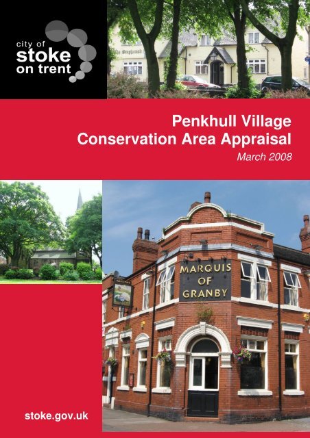
architectural or historic interest. They are not comprehensive inventories of everything that issignificant about a building and nothing should be dismissed as unimportant simply becauseit is not described in the list descripti<strong>on</strong>.5.42 Buildings of Special Local Interest Listed in The Local Plan• There are no Buildings of Special Local Interest within the <str<strong>on</strong>g>C<strong>on</strong>servati<strong>on</strong></str<strong>on</strong>g> <str<strong>on</strong>g>Area</str<strong>on</strong>g>.5.43 Unlisted Structures of NoteMost buildings within the <str<strong>on</strong>g>Area</str<strong>on</strong>g> pre-dating 1950 make a positive c<strong>on</strong>tributi<strong>on</strong> to thecharacter of the <str<strong>on</strong>g>Area</str<strong>on</strong>g>, though alterati<strong>on</strong>s have reduced this in a number of cases. Thefollowing selecti<strong>on</strong> of notable unlisted buildings is by no means comprehensive:• The Marquis of Granby: Rebuilt in the 1890’s <strong>on</strong> a previously existing public housethis building is a prominent feature within the <str<strong>on</strong>g>C<strong>on</strong>servati<strong>on</strong></str<strong>on</strong>g> <str<strong>on</strong>g>Area</str<strong>on</strong>g> providing a visualanchor at the core of the area.• 2 Thomas Ward Place (Beech Grove): Large house built in the late 1700’s for JohnHarris<strong>on</strong>. In 2002 planning permissi<strong>on</strong> was given to c<strong>on</strong>vert the former nursinghome into a dwelling house and build 7 new dwellings <strong>on</strong> the site.• 33 St Thomas Place: A large detached dwelling with associated outbuildings in anearly vernacular style with later Georgian modificati<strong>on</strong>s.• 3 D<strong>on</strong>caster Lane (The Old Vicarage): A large detached built around the 1880’s toreplace a smaller building. Believed to have been designed by local architectCharles Lynam, this large brick building has Dutch gables and retains many originalfeatures.FIGURE 18: The Marquis of Granby22
FIGURE 19: 3 D<strong>on</strong>caster Lane (the old vicarage)5.4 Trees, Green Spaces, Edges and Ecology5.41 The <str<strong>on</strong>g>C<strong>on</strong>servati<strong>on</strong></str<strong>on</strong>g> <str<strong>on</strong>g>Area</str<strong>on</strong>g> benefits from many mature large trees but few public openspaces.5.42 Out of the former graveyard of the church of St Thomas the Apostle has been created asmall landscaped public space with paths and seating.5.43 The area adjacent to ‘The Views’ <strong>on</strong> <str<strong>on</strong>g>Penkhull</str<strong>on</strong>g> New Road is mowed grass which gives anatural and green feel to the area as you enter the village.5.44 The fields around and relating to <str<strong>on</strong>g>Penkhull</str<strong>on</strong>g> Farm are currently unused green space.5.45 The gardens of ‘The Mount’, (Willows school) the former home of Josiah Spode back<strong>on</strong> to D<strong>on</strong>caster Lane creating a str<strong>on</strong>g green setting to the end of the lane.5.46 The <str<strong>on</strong>g>C<strong>on</strong>servati<strong>on</strong></str<strong>on</strong>g> <str<strong>on</strong>g>Area</str<strong>on</strong>g> stands <strong>on</strong> the top of a hill and is not overlooked by anybuildings, indeed buildings within and surrounding the area are c<strong>on</strong>sistently two orthree storey <strong>on</strong>ly.23
5.5 Detractors, Neutral <str<strong>on</strong>g>Area</str<strong>on</strong>g>s and Gap Sites – Enhancement andDevelopment Opportunities5.51 Features which detract from the character and appearance of the <str<strong>on</strong>g>C<strong>on</strong>servati<strong>on</strong></str<strong>on</strong>g> <str<strong>on</strong>g>Area</str<strong>on</strong>g>include:• The shops <strong>on</strong> Manor Court Street are not well maintained and not in keeping withthe character of the <str<strong>on</strong>g>C<strong>on</strong>servati<strong>on</strong></str<strong>on</strong>g> <str<strong>on</strong>g>Area</str<strong>on</strong>g>.• The fields around and relating to <str<strong>on</strong>g>Penkhull</str<strong>on</strong>g> Farm are currently unused green spacewhich could be utilised to enable development of the farm.FIGURE 20: Boarded up shopfr<strong>on</strong>ts and buildings which have not been well maintained createan unloved look to the <str<strong>on</strong>g>C<strong>on</strong>servati<strong>on</strong></str<strong>on</strong>g> <str<strong>on</strong>g>Area</str<strong>on</strong>g>5.52 Neutral <str<strong>on</strong>g>Area</str<strong>on</strong>g>s – those neither c<strong>on</strong>tributing to nor detracting from the character orappearance of the <str<strong>on</strong>g>C<strong>on</strong>servati<strong>on</strong></str<strong>on</strong>g> <str<strong>on</strong>g>Area</str<strong>on</strong>g>:• The 1970’s housing <strong>on</strong> Rothwell Street does not give a positive or negativecharacter to the <str<strong>on</strong>g>C<strong>on</strong>servati<strong>on</strong></str<strong>on</strong>g> <str<strong>on</strong>g>Area</str<strong>on</strong>g>. It creates a sense of space and place byvirtue of its layout and design but is not in keeping with the general character of thearea.5.53 There are no gap sites within the <str<strong>on</strong>g>C<strong>on</strong>servati<strong>on</strong></str<strong>on</strong>g> <str<strong>on</strong>g>Area</str<strong>on</strong>g>.24
6. Pressures and Threats6.1 The area to the South West of the <str<strong>on</strong>g>C<strong>on</strong>servati<strong>on</strong></str<strong>on</strong>g> <str<strong>on</strong>g>Area</str<strong>on</strong>g> includes several derelictbuildings. These may be redeveloped at a future date but currently the buildings,particularly the listed <str<strong>on</strong>g>Penkhull</str<strong>on</strong>g> Farm, are in need of urgent repair.6.2 There is a small strip of grass and trees between ‘The Views’ and <str<strong>on</strong>g>Penkhull</str<strong>on</strong>g> New Roadwhich may be proposed for development in the future. This area forms an importantbarrier for the listed buildings adjacent and creates an important green entrance into thevillage.6.3 There are some garages to the rear of Manor Court Street behind the Greyhound Innwhich may come under pressure of development in the future. Any proposals shouldrespect the character and scale of the <str<strong>on</strong>g>C<strong>on</strong>servati<strong>on</strong></str<strong>on</strong>g> <str<strong>on</strong>g>Area</str<strong>on</strong>g> and the listed building.6.4 There are many buildings which were built in the 1970’s within the <str<strong>on</strong>g>C<strong>on</strong>servati<strong>on</strong></str<strong>on</strong>g> <str<strong>on</strong>g>Area</str<strong>on</strong>g>and in the future these may be redeveloped.25
7. Summary of Special InterestArchitectureThe <str<strong>on</strong>g>C<strong>on</strong>servati<strong>on</strong></str<strong>on</strong>g> <str<strong>on</strong>g>Area</str<strong>on</strong>g> has a wide variety of buildings as suits the vernacular development ofthe area. A few traditi<strong>on</strong>al buildings remain and these form a core part of the character of thearea. The <str<strong>on</strong>g>C<strong>on</strong>servati<strong>on</strong></str<strong>on</strong>g> <str<strong>on</strong>g>Area</str<strong>on</strong>g> is characterised by plain buildings without intricate detailing.HistoryThe village has a l<strong>on</strong>g history which can be dated back to the Domesday Book. It has notevolved in the same way as a majority of the other parts of the city and has been allowed todevelop naturally. There have been some changes in the 1970’s but the original form of thevillage has remained the same.Character and AppearanceThe <str<strong>on</strong>g>C<strong>on</strong>servati<strong>on</strong></str<strong>on</strong>g> <str<strong>on</strong>g>Area</str<strong>on</strong>g> has retained its rural and village feel despite being in the middle ofthe c<strong>on</strong>urbati<strong>on</strong> of <str<strong>on</strong>g>Stoke</str<strong>on</strong>g>-<strong>on</strong>-<strong>Trent</strong>. This is partly due to the central village ‘green’ and thelocal resident’s str<strong>on</strong>g identificati<strong>on</strong> with the village and its history.26
8. Recommendati<strong>on</strong>s and Proposals8.1 Boundaries:Boundaries in each case are suggested by natural breaks in townscape character orhistorical developmental patterns and relati<strong>on</strong>ships. Current boundaries are appropriateand therefore no boundary revisi<strong>on</strong>s are proposed.8.2 The current Article 4 designati<strong>on</strong> covers the whole of the original <str<strong>on</strong>g>C<strong>on</strong>servati<strong>on</strong></str<strong>on</strong>g> <str<strong>on</strong>g>Area</str<strong>on</strong>g>(the Core area) and relates to all elevati<strong>on</strong>s of the dwellings. This could be extendedto cover the whole of the area. There are currently no restricti<strong>on</strong>s over doors orwindows but there are no proposals to put an article 4 Directi<strong>on</strong> relating to this in placeas a majority of these elements of the buildings in the <str<strong>on</strong>g>C<strong>on</strong>servati<strong>on</strong></str<strong>on</strong>g> <str<strong>on</strong>g>Area</str<strong>on</strong>g> have beenaltered.8.3 Some of the notable unlisted buildings included in secti<strong>on</strong> 5.43 might be c<strong>on</strong>sidered forinclusi<strong>on</strong> in the Local List at its next review.27
SourcesBooks/Pamphlets/web pagesVictoria County History Vol. VIII.http://www.thepotteries.org/walks/penkhull/index.htmhttp://www.stokecoll.ac.uk/penkhull/index.asphttp://www.british-history.ac.uk/http://www.bbc.co.uk/stoke/c<strong>on</strong>tent/articles/2006/04/06/history_penkhull_windmill_feature.shtml<str<strong>on</strong>g>Penkhull</str<strong>on</strong>g> Remembered Again. R. Talbot. Cartwright Bros. (Printers) Ltd. 1980.Social History Walks 2001; <str<strong>on</strong>g>Penkhull</str<strong>on</strong>g> Garden <str<strong>on</strong>g>Village</str<strong>on</strong>g>, <str<strong>on</strong>g>Stoke</str<strong>on</strong>g>-<strong>on</strong>-<strong>Trent</strong>. A. Dobraszczyc.MapsYates map of 1775 from Staffordshire Archaeological Studies – Museum ArchaeologicalSociety Report, New Series No.4 1987Ariel Photograph – <str<strong>on</strong>g>Stoke</str<strong>on</strong>g>-<strong>on</strong>-<strong>Trent</strong> <strong>City</strong> CouncilOS various scales: 1880, 1900, 1937,PhotographsOriginal pictures (<str<strong>on</strong>g>Penkhull</str<strong>on</strong>g> <str<strong>on</strong>g>Village</str<strong>on</strong>g> <str<strong>on</strong>g>C<strong>on</strong>servati<strong>on</strong></str<strong>on</strong>g> <str<strong>on</strong>g>Area</str<strong>on</strong>g> <str<strong>on</strong>g>Appraisal</str<strong>on</strong>g>) 2002.Original pictures.Staffordshire Past-track.Policy documents to which reference madeDoE, 1995: PPG15: Planning and the Historic Envir<strong>on</strong>ment.General Permitted Development Order 1995.Government Office for the West Midlands: RPG 11 Regi<strong>on</strong>al Planning Guidance for the WestMidlands.Planning (Listed Buildings and <str<strong>on</strong>g>C<strong>on</strong>servati<strong>on</strong></str<strong>on</strong>g> <str<strong>on</strong>g>Area</str<strong>on</strong>g>s) Act 1990.Staffordshire and <str<strong>on</strong>g>Stoke</str<strong>on</strong>g>-<strong>on</strong>-<strong>Trent</strong> Structure Plan 1996-2011.<str<strong>on</strong>g>Stoke</str<strong>on</strong>g>-<strong>on</strong>-<strong>Trent</strong> <strong>City</strong> Council: Local Plan 2001.28
AppendicesYates map of 1775 from Staffordshire Archaeological Studies – MuseumArchaeological Society Report, New Series No.4 198729
Ordinance Survey Map <str<strong>on</strong>g>Penkhull</str<strong>on</strong>g> from 188030
Ordinance Survey Map <str<strong>on</strong>g>Penkhull</str<strong>on</strong>g> from 190031
Ordinance Survey Map <str<strong>on</strong>g>Penkhull</str<strong>on</strong>g> from 193732
Buildings <strong>on</strong> the Statutory ListTHE VIEWS & HOUSE ADJOINING THE VIEWS1 & 2 The Views,Off <str<strong>on</strong>g>Penkhull</str<strong>on</strong>g> New Road,<str<strong>on</strong>g>Penkhull</str<strong>on</strong>g>.ST4 5DGGRADE IISoTCC List No: 113 A & BGRID REF:387005E344866NHARTSHILL AND PENKHULL WARD DATE LISTED: 19 th April 1972PENKHULL VILLAGE CONSERVATION AREALIST DESCRIPTIONLASTAMENDED:15 th March 1993Pair of houses. Early 19th Century. Painted brick with plain tiled roof. 2-storeyed, of <strong>on</strong>e and twounit plan. The larger house has central doorway in flat roofed porch with round arched entrance,flanked by wide 16-pane sash windows with flat arched rendered heads <strong>on</strong> each floor, and anadditi<strong>on</strong>al window over the doorway. Central rear wing, and lower added or raised bay to the leftwith squared bay window. The smaller house has a doorway to the left beneath a wood canopycarried <strong>on</strong> moulded c<strong>on</strong>sole brackets, and a canted bay window with slate roof and small upperpanes to sashes. 16-pane sashes above. Side wall stacks in both dwellings. Modilli<strong>on</strong> eavescornice across the whole facade.----------------------------------------------------------------------------------------------------------ELM TREE HOUSEGarden Street,<str<strong>on</strong>g>Penkhull</str<strong>on</strong>g>.ST4 5DYGRADE IISoTCC List No: 110GRID REF:386786E344853HARTSHILL AND PENKHULL WARD DATE LISTED: 19 April 1989PENKHULL VILLAGE CONSERVATION AREALASTAMENDED:LIST DESCRIPTIONHouse. Dated 1694 but extensively modified in the 18th and 19th Century. Red and blue brickwith plain tiled roof.2-storeyed, main range of 2 units with doorway at left of elevati<strong>on</strong> in flatroofed added porch. Early 20th Century 4-light casement window with leaded upper lights to left,earlier windows with segmentally arched heads to right and first floor. Small triangular orielwindow in centre of elevati<strong>on</strong>, probably replacing former fire-place window. Moulded sill band,date <strong>on</strong> a tile with initials O.D.I.C. Tier of windows in gable end, a tripartite sash window toground floor casements above and to attic, all renewed in early openings with deep camberedheads. Inserted doorway to right of gable. Lower rear wing with canted bay window. Axial stack.N/A33
GREYHOUND INNManor Court Street,<str<strong>on</strong>g>Penkhull</str<strong>on</strong>g>ST4 5DWGRADE IISoTCC List No: 112GRID REF:386883E344818NHARTSHILL AND PENKHULL WARD DATE LISTED: 19 th April 1972PENKHULL VILLAGE CONSERVATION AREALASTAMENDED:15 th March 1993LIST DESCRIPTIONPublic House, originally dwelling. Plan and main structure largely of the late 16th Century, butwith later alterati<strong>on</strong>s, especially a partial rebuild in 1936. Roughcast over partial timber frame,and brick, with plain tiled roof. 2-storeyed, hall and cross wing in plan. Gable cross wing to left,with 4-light mulli<strong>on</strong>ed windows <strong>on</strong> each floor with flat hood-moulds with label stops. Door inadded lean-to porch in the angle of hall and cross wing, backing <strong>on</strong> to stack, and probably theoriginal doorway. Further gabled porch in centre of main range, probably inserted in lateralterati<strong>on</strong>s making the facade symmetrical. It is flanked by 3-light casement windows, and 2gabled dormers above, with ornate bargeboards. Gable and axial stacks.(The Victoria History of the Counties of England: R.B.Pugh: Staffordshire: Oxford: 1963-).----------------------------------------------------------------------------------------------------------CHURCH OF THOMAS THE APOSTLEManor Court Street,<str<strong>on</strong>g>Penkhull</str<strong>on</strong>g>.ST4 5DWGRADE IISoTCC List No: 111GRID REF:386916E344805NHARTSHILL AND PENKHULL WARD DATE LISTED: 19 th April 1972PENKHULL VILLAGE CONSERVATION AREALASTAMENDED:LIST DESCRIPTIONParish Church. 1842, by George Gilbert Scott, but with later alterati<strong>on</strong>s. Coursed and squaredsandst<strong>on</strong>e rubble with plain tiled roofs. West tower and spire, nave with added lean-to aisles andtransepts, chancel. 3-stage tower with broach spire with lucarnes. Aisles added in 1892, withwindows grouped as 3 ogival arches. Dormers lighting nave presumably added at the same time.Paired lancet lights to transepts. 3-light decorated----------------------------------------------------------------------------------------------------------N/APENKHULL FARMHOUSEGarden Street (South side),<str<strong>on</strong>g>Penkhull</str<strong>on</strong>g>.ST4 5DYHARTSHILL AND PENKHULL WARDGRADE IIPENKHULL VILLAGE CONSERVATION AREASoTCC List No: 10044GRID REF:DATE LISTED:LASTAMENDED:386824E344785N21 st August2002N/ALIST DESCRIPTIONFarmhouse. Late C18, some mid C19 alterati<strong>on</strong> and extensi<strong>on</strong>. Brick, cement rendered (lined outas ashlar block) to fr<strong>on</strong>t and rear wing; gabled plain tile roofs, with rendered end stacks to fr<strong>on</strong>t34
and brick stack at juncti<strong>on</strong> of rear wings. T-shaped plan with rear wing having lean-to to its E andmid C19 block extending at right angles to W. 2-storeys. 4-window S fr<strong>on</strong>t with lintels over halfglazedmid C19 panelled door and horned glazing bar sashes (3/6 to first floor, 6/6 below); similarsashes to mid C19 canted bay window <strong>on</strong> right. Late C19 and C20 timber casements to rear,except E elevati<strong>on</strong> which has 3/6-pane sash and, to gable end of rear cross wing, stepped lintelover small-paned timber casement.Interior: the interior has been little altered since the C19. Features include late C18 mouldedcornicing and joinery, including panelled doors and shutters in moulded architraves with originalfitments. Simple classical fireplaces with late C18 and mid C19 cast ir<strong>on</strong> grates, that to parlourhaving mid C19 overmantle mirror. Panelled earth closet. Stairhall with elliptical arch <strong>on</strong> mouldedbrackets: fine staircase with moulded balusters to open-string and wreathed handrail.History: the house probably dates from so<strong>on</strong> after 1780, when Josiah Spode II leased the farm. Itchanged ownership in 1830 with the sale of farm stock to John Smith, and was bought by JohnPilkingt<strong>on</strong> in 1855.35


