Annual Report 2005 (62.7MB) - Western Riverside County Regional ...
Annual Report 2005 (62.7MB) - Western Riverside County Regional ...
Annual Report 2005 (62.7MB) - Western Riverside County Regional ...
- No tags were found...

Create successful ePaper yourself
Turn your PDF publications into a flip-book with our unique Google optimized e-Paper software.
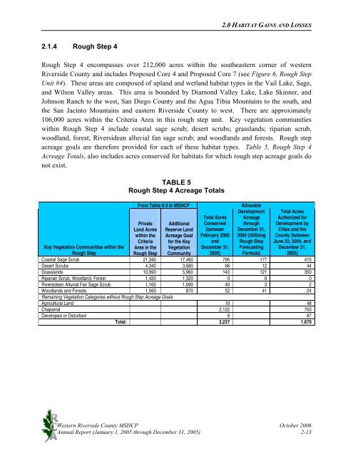
2.0 HABITAT GAINS AND LOSSES2.1.4 Rough Step 4Rough Step 4 encompasses over 212,000 acres within the southeastern corner of western<strong>Riverside</strong> <strong>County</strong> and includes Proposed Core 4 and Proposed Core 7 (see Figure 6, Rough StepUnit #4). These areas are composed of upland and wetland habitat types in the Vail Lake, Sage,and Wilson Valley areas. This area is bounded by Diamond Valley Lake, Lake Skinner, andJohnson Ranch to the west, San Diego <strong>County</strong> and the Agua Tibia Mountains to the south, andthe San Jacinto Mountains and eastern <strong>Riverside</strong> <strong>County</strong> to west. There are approximately106,000 acres within the Criteria Area in this rough step unit. Key vegetation communitieswithin Rough Step 4 include coastal sage scrub; desert scrubs; grasslands; riparian scrub,woodland, forest; <strong>Riverside</strong>an alluvial fan sage scrub; and woodlands and forests. Rough stepacreage goals are therefore provided for each of these habitat types. Table 5, Rough Step 4Acreage Totals, also includes acres conserved for habitats for which rough step acreage goals donot exist.TABLE 5Rough Step 4 Acreage TotalsFrom Table 6-3 in MSHCPPrivateLand Acreswithin theCriteriaArea in theRough StepAdditionalReserve LandAcreage Goalfor the KeyVegetationCommunityTotal AcresConserved(betweenFebruary 2000andDecember 31,<strong>2005</strong>)AllowableDevelopmentAcreagethroughDecember 31,<strong>2005</strong> (UtilizingRough StepForecastingFormula)Total AcresAuthorized forDevelopment byCities and the<strong>County</strong> (betweenJune 22, 2004, andDecember 31,<strong>2005</strong>)Key Vegetation Communities within theRough StepCoastal Sage Scrub 21,340 17,460 795 177 415Desert Scrubs 4,340 3,680 66 12 44Grasslands 10,990 5,960 143 121 350Riparian Scrub, Woodland, Forest 1,420 1,320 0 0 0<strong>Riverside</strong>an Alluvial Fan Sage Scrub 1,160 1,090 40 3 2Woodlands and Forests 1,560 870 52 41 24Remaining Vegetation Categories without Rough Step Acreage GoalsAgricultural Land 10 48Chaparral 2,122 700Developed or Disturbed 9 87Total: 3,237 1,670<strong>Western</strong> <strong>Riverside</strong> <strong>County</strong> MSHCP October 2006<strong>Annual</strong> <strong>Report</strong> (January 1, <strong>2005</strong> through December 31, <strong>2005</strong>) 2-13