STORM TIDE EVACUATION GUIDE - Townsville City Council
STORM TIDE EVACUATION GUIDE - Townsville City Council
STORM TIDE EVACUATION GUIDE - Townsville City Council
- No tags were found...

You also want an ePaper? Increase the reach of your titles
YUMPU automatically turns print PDFs into web optimized ePapers that Google loves.
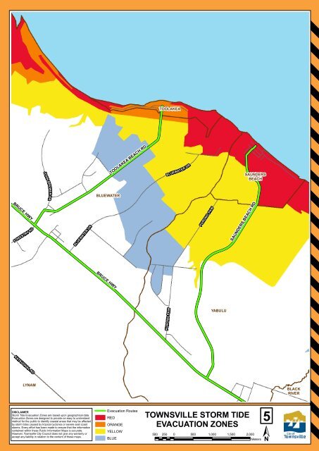
JOHN BREWER DRTOOLAKEATOOLAKEA BEACH RDBLUEWATER DRSAUNDERSBEACHBLUEWATERBRUCE HWYFORESTRY RDBLUEWATER DRPURONO PKWSAUNDERS BEACH RDBRUCE HWYPURONO PKWYABULUKATAUGHAL RDLYNAMBLACKRIVERDISCLAIMERStorm Tide Evacuation Zones are based upon geographical data.Evacuation Zones are designed to provide an easy to understandmethod for the public to identify coastal areas that may be affectedby storm tides caused by tropical cyclones or severe east coaststorms. Every effort has been made to ensure that the informationcontained within these Public Information Maps is accurate.However, <strong>Townsville</strong> <strong>City</strong> <strong>Council</strong> does not give any warranty oraccept any liability in relation to the content of these maps.Evacuation RoutesREDORANGEYELLOWBLUETOWNSVILLE <strong>STORM</strong> <strong>TIDE</strong><strong>EVACUATION</strong> ZONES500 250 0 500 1,000 1,500 2,00015Meters5