STORM TIDE EVACUATION GUIDE - Townsville City Council
STORM TIDE EVACUATION GUIDE - Townsville City Council
STORM TIDE EVACUATION GUIDE - Townsville City Council
- No tags were found...

Create successful ePaper yourself
Turn your PDF publications into a flip-book with our unique Google optimized e-Paper software.
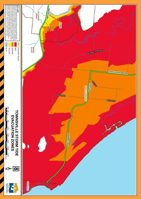
NOMEALLIGATORCREEKDISCLAIMERStorm Tide Evacuation Zones are based upon geographical data.Evacuation Zones are designed to provide an easy to understandmethod for the public to identify coastal areas that may be affectedby storm tides caused by tropical cyclones or severe east coaststorms. Every effort has been made to ensure that the informationcontained within these Public Information Maps is accurate.However, <strong>Townsville</strong> <strong>City</strong> <strong>Council</strong> does not give any warranty oraccept any liability in relation to the content of these maps.BRUCE HWYMOUNTELLIOTEvacuation RoutesREDORANGEYELLOWBLUECROCODILE CREEK RDCAPE CLEVELAND RDCAPE CLEVELANDRILEY R DMEEHAN RD MEEHAN RDCARTY RDTOWNSVILLE <strong>STORM</strong> <strong>TIDE</strong><strong>EVACUATION</strong> ZONES500 250 0 500 1,000 1,500 2,000 2,500 3,000MetersGOODSELL RD8CUNGULLA18