

Biodiversity Guide - The Intertwine
Biodiversity Guide - The Intertwine
Biodiversity Guide - The Intertwine

You also want an ePaper? Increase the reach of your titles
YUMPU automatically turns print PDFs into web optimized ePapers that Google loves.
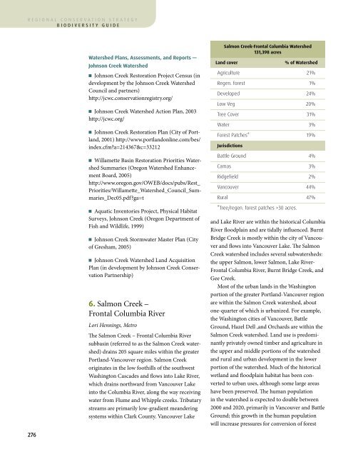
egional conservation strategybiodiversity guideAppendix I WatershedsWatershed Plans, Assessments, and Reports —Johnson Creek Watershedn Johnson Creek Restoration Project Census (indevelopment by the Johnson Creek WatershedCouncil and partners)http://jcwc.conservationregistry.org/n Johnson Creek Watershed Action Plan, 2003http://jcwc.org/n Johnson Creek Restoration Plan (City of Portland,2001) http://www.portlandonline.com/bes/index.cfm?a=214367&c=33212n Willamette Basin Restoration Priorities WatershedSummaries (Oregon Watershed EnhancementBoard, 2005)http://www.oregon.gov/OWEB/docs/pubs/Rest_Priorities/Willamette_Watershed_Council_Summaries_Dec05.pdf?ga=tn Aquatic Inventories Project, Physical HabitatSurveys, Johnson Creek (Oregon Department ofFish and Wildlife, 1999)n Johnson Creek Stormwater Master Plan (Cityof Gresham, 2005)n Johnson Creek Watershed Land AcquisitionPlan (in development by Johnson Creek ConservationPartnership)6. Salmon Creek –Frontal Columbia RiverLori Hennings, Metro<strong>The</strong> Salmon Creek – Frontal Columbia Riversubbasin (referred to as the Salmon Creek watershed)drains 205 square miles within the greaterPortland-Vancouver region. Salmon Creekoriginates in the low foothills of the southwestWashington Cascades and flows into Lake River,which drains northward from Vancouver Lakeinto the Columbia River, along the way receivingwater from Flume and Whipple creeks. Tributarystreams are primarily low-gradient meanderingsystems within Clark County. Vancouver LakeSalmon Creek-Frontal Columbia Watershed131,398 acresLand cover% of WatershedAgriculture 21%Regen. forest 1%Developed 24%Low Veg 20%Tree Cover 31%Water 3%Forest Patches* 19%JurisdictionsBattle Ground 4%Camas 3%Ridgefield 2%Vancouver 44%Rural 47%*Tree/regen. forest patches >30 acres.<strong>The</strong> Salmon Creek watershed lies along thePacific Flyway and is critical to migrating andbreeding birds. Meriwether Lewis and WilliamClark camped near the mouth of Salmon Creekon November 4, 1805. Clark purportedly did notsleep well because of the noise made by swans,geese, ducks, and other birds nearby.Stream health and fish and wildlife habitatwithin the watershed have been affected by urbanand rural development, agricultural practices,transportation corridors, and timber harvest.Salmon Creek currently exceeds state and federalstandards for water temperature, turbidity, andcoliform bacteria, and tributaries also have problemswith dissolved oxygen and pH. Floodplainconnectivity has been lost and streams channelandLake River are within the historical ColumbiaRiver floodplain and are tidally influenced. BurntBridge Creek is mostly within the city of Vancouverand flows into Vancouver Lake. <strong>The</strong> SalmonCreek watershed includes several subwatersheds:the upper Salmon, lower Salmon, Lake River-Frontal Columbia River, Burnt Bridge Creek, andGee Creek.Most of the urban lands in the Washingtonportion of the greater Portland-Vancouver regionare within the Salmon Creek watershed, aboutone-quarter of which is urbanized. For example,the Washington cities of Vancouver, BattleGround, Hazel Dell ,and Orchards are within theSalmon Creek watershed. Land use is predominantlyprivately owned timber and agriculture inthe upper and middle portions of the watershedand rural and urban development in the lowerportion of the watershed. Much of the historicalwetland and floodplain habitat has been convertedto urban uses, although some large areashave been preserved. <strong>The</strong> human populationin the watershed is expected to double between2000 and 2020, primarily in Vancouver and BattleGround; this growth in the human populationwill increase pressures for conversion of forestand rural lands to high-density suburban andurban uses.A total of 53 percent of the watershed lieswithin urban growth boundaries, and the watershedrepresents 7 percent of the total area of thegreater Portland-Vancouver region.Key Facts: <strong>The</strong> Salmon Creek – Frontal ColumbiaRiver watershed within the greater Portland-Vancouver region:n Consists of 24 percent developed land cover(much of which is within the City of Vancouver’surban growth area) and 21 percent agriculture.n Includes 31 percent tree cover. Forest patchcover represents 19 percent of the watershed,reflecting the fragmentation of habitat that iscommon in urban areas.n Has 20 percent low vegetation. <strong>The</strong> combinationof tree cover and low vegetation (collectivelymore than 50 percent) suggests that the watershedis relatively green, despite its urbanization.n Is 11 percent publicly owned.n Has about 22,000 acres within the FEMA 100-year floodplain.n Includes more than 16,000 acres of mappedwetlands—the most of any watershed in theregion.ized. High peak flows and low summer flows arekey urban issues, so development practices andstormwater management will be important toolsin managing future urban growth. Clark PublicUtilities, Clark County, and the WashingtonDepartment of Ecology have entered into a jointagreement to develop and maintain an effectivemanagement strategy for the watershed’s groundwaterresources, which supply most of the waterneeds of residents and businesses.Historically, the Salmon Creek subbasin was53 percent coniferous forest, 18 percent burnedforest, 9 percent prairie and savanna, and 3percent oak. By 2010, 32 percent of the watershedhad been converted to urban uses (i.e., thecities of Battle Ground, Ridgefield, and Vancouver,and part of the city of Camas), making thisbasin the third most heavily urbanized in theregion. Conversion to urban cover consumedabout 56 percent (approximately 30,000 acres)of combined coniferous and mixed forest andabout 5,000 acres of prairie. Agriculture covered aquarter of the basin and consumed about 20,000acres of conifer and mixed forest and 3,000 acresof prairie. Riparian forest and water features—primarily on the floodplain of the ColumbiaRiver—each were reduced about 21 percent byfilling or drainage.Habitat loss, fragmentation, and invasivespecies are of particular concern in the SalmonCreek watershed. Native oak habitats and prairiesare threatened by Scot’s broom. Purple loosestrifeand knotweeds affect wetland and riparian276 277

