Furze Platt Triangle - The Royal Borough of Windsor and Maidenhead
Furze Platt Triangle - The Royal Borough of Windsor and Maidenhead
Furze Platt Triangle - The Royal Borough of Windsor and Maidenhead
- No tags were found...

Create successful ePaper yourself
Turn your PDF publications into a flip-book with our unique Google optimized e-Paper software.
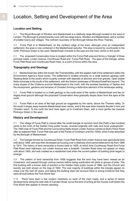
18<strong>Furze</strong> <strong>Platt</strong> <strong>Triangle</strong> Conservation Area Appraisal5Location, Setting <strong>and</strong> Development <strong>of</strong> the AreaLocation <strong>and</strong> Setting5.1 <strong>The</strong> <strong>Royal</strong> <strong>Borough</strong> <strong>of</strong> <strong>Windsor</strong> <strong>and</strong> <strong>Maidenhead</strong> is a relatively large <strong>Borough</strong> located to the west <strong>of</strong>London. <strong>The</strong> <strong>Borough</strong> is predominantly rural, with two large towns, <strong>Windsor</strong> <strong>and</strong> <strong>Maidenhead</strong>, <strong>and</strong> a number<strong>of</strong> smaller towns <strong>and</strong> villages. <strong>The</strong> northern boundary <strong>of</strong> the <strong>Borough</strong> follows the River Thames.5.2 <strong>Furze</strong> <strong>Platt</strong> is in <strong>Maidenhead</strong>, on the northern edge <strong>of</strong> the town, although once an independentsettlement, the area is now contained in the <strong>Maidenhead</strong> suburbs. <strong>The</strong> area is bound by countryside to thenorth, Pinkneys Green to the west, <strong>Maidenhead</strong> riverside to the east <strong>and</strong> the town centre to the south.5.3 <strong>The</strong> proposed Conservation Area is located within the <strong>Furze</strong> <strong>Platt</strong> area <strong>and</strong> forms a 'triangle' <strong>of</strong> threeprincipal roads, Linden Avenue, Courthouse Road <strong>and</strong> <strong>Furze</strong> <strong>Platt</strong> Road. <strong>The</strong> apex <strong>of</strong> the triangle, where<strong>Furze</strong> <strong>Platt</strong> Road <strong>and</strong> Courthouse Road meet, is a point <strong>of</strong> focus within the area.Topography <strong>and</strong> Geology5.4 <strong>Maidenhead</strong> lies within the broad, flat ThamesValley, with the eastern half <strong>of</strong> the settlement within theEnvironment Agency’s flood zones. <strong>The</strong> settlement is located primarily on a chalk bedrock geology (withReading Beds to the south) which is partly overlain with deposits <strong>of</strong> alluvium <strong>and</strong> river gravels. Open arablefields dominate to the south <strong>of</strong> the settlement, with the historic l<strong>and</strong>scape <strong>of</strong> <strong>Windsor</strong>GreatPark beyond. <strong>The</strong>scarp slopes <strong>of</strong> the Chilterns encircle <strong>Maidenhead</strong> to the north, with the wooded backdrop <strong>of</strong> Taplow <strong>and</strong>the escarpment, gardens <strong>and</strong> terraces <strong>of</strong> Cliveden forming a distinctive element <strong>of</strong> the l<strong>and</strong>scape setting.5.5 <strong>Furze</strong> <strong>Platt</strong> is located on a chalk geology to the north-west <strong>of</strong> the centre <strong>of</strong> <strong>Maidenhead</strong> <strong>and</strong> lies onlargely level ground although the proposed Conservation Area gradually slopes down from the apex at thenorth.5.6 <strong>Furze</strong> <strong>Platt</strong> is an area <strong>of</strong> flat high ground as suggested by the name, above the Thames valley. Tothe south it slopes away towards <strong>Maidenhead</strong> town centre, <strong>and</strong> to the east down towards Boulter’s lock <strong>and</strong>Cliveden reach. To the north the l<strong>and</strong> rises again up to Cookham Dean, with a more gentle rise towardsPinkneys Green in the west.History <strong>and</strong> Development5.7 <strong>The</strong> village <strong>of</strong> <strong>Furze</strong> <strong>Platt</strong> is named after the small triangle <strong>of</strong> common l<strong>and</strong> (the <strong>Platt</strong>) a few hundredyards to the north <strong>of</strong> the Golden Harp public house, covered originally with oaks <strong>and</strong> furze undergrowth.<strong>The</strong> 1840 map <strong>of</strong> <strong>Furze</strong> <strong>Platt</strong> <strong>and</strong> the surrounding fields shows Linden Avenue named as Bull’s Piece Roadafter an adjacent field. <strong>Furze</strong> <strong>Platt</strong> was part <strong>of</strong> the Parish <strong>of</strong> Cookham until the 1930s, when it was absorbedby the <strong>Borough</strong> <strong>of</strong> <strong>Maidenhead</strong>.5.8 <strong>The</strong> triangle formed by Courthouse Road, <strong>Furze</strong> <strong>Platt</strong> Road And Linden Avenue was agricultural l<strong>and</strong>until about 1885, <strong>and</strong> was then developed as housing over a relatively short period believed to be from 1889to 1914. <strong>The</strong> history <strong>of</strong> l<strong>and</strong> ownership is known back to 1829, at which time Courthouse Road And <strong>Furze</strong><strong>Platt</strong> Road were highways, but Linden Avenue was a footpath. Camden Road does not appear on mapsuntil about 1900, <strong>and</strong> was created as a residential road when the current pattern <strong>of</strong> building plots began toemerge.5.9 <strong>The</strong> pattern <strong>of</strong> l<strong>and</strong> ownership from 1858 suggests that the l<strong>and</strong> may have been viewed as aninvestment, <strong>and</strong> passed through various owners before being subdivided into plots or groups <strong>of</strong> plots. <strong>The</strong>first building with a known date <strong>of</strong> erection is the Golden Harp public house <strong>of</strong> 1889, <strong>and</strong> the Church <strong>and</strong>laundry are both shown on the map <strong>of</strong> 1900. <strong>The</strong> vast majority <strong>of</strong> buildings within the triangle appear onmaps over the next 25 years, <strong>and</strong> taking the building style into account there is strong evidence that theywere all built before the First World War5.10 <strong>The</strong>re have been a few modern insertions on each <strong>of</strong> the main roads, <strong>and</strong> a series <strong>of</strong> recentdevelopments along the east side <strong>of</strong> Camden Road, but at the time <strong>of</strong> writing all the houses built before theFirst World War appear to remain st<strong>and</strong>ing.