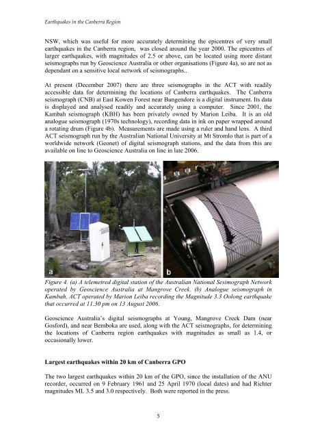
<strong>Earthquakes</strong> <strong>in</strong> <strong>the</strong> <strong>Canberra</strong> <strong>Region</strong>NSW, which was useful for more accurately determ<strong>in</strong><strong>in</strong>g <strong>the</strong> epicentres of very smallearthquakes <strong>in</strong> <strong>the</strong> <strong>Canberra</strong> region, was closed around <strong>the</strong> year 2000. The epicentres oflarger earthquakes, with magnitudes of 2.5 or above, can be located us<strong>in</strong>g more distantseismographs run by <strong>Geoscience</strong> <strong>Australia</strong> or o<strong>the</strong>r organisations (Figure 4a), so are not asdependant on a sensitive local network of seismographs..At present (December 2007) <strong>the</strong>re are three seismographs <strong>in</strong> <strong>the</strong> ACT with readilyaccessible data for determ<strong>in</strong><strong>in</strong>g <strong>the</strong> locations of <strong>Canberra</strong> earthquakes. The <strong>Canberra</strong>seismograph (CNB) at East Kowen Forest near Bungendore is a digital <strong>in</strong>strument. Its datais displayed and analysed readily and accurately us<strong>in</strong>g a computer. S<strong>in</strong>ce 2001, <strong>the</strong>Kambah seismograph (KBH) has been privately owned by Marion Leiba. It is an oldanalogue seismograph (1970s technology), record<strong>in</strong>g data <strong>in</strong> <strong>in</strong>k on paper wrapped arounda rotat<strong>in</strong>g drum (Figure 4b). Measurements are made us<strong>in</strong>g a ruler and hand lens. A thirdACT seismograph run by <strong>the</strong> <strong>Australia</strong>n National University at Mt Stromlo that is part of aworldwide network (Geonet) of digital seismograph stations, and <strong>the</strong> data from this areavailable on l<strong>in</strong>e to <strong>Geoscience</strong> <strong>Australia</strong> on l<strong>in</strong>e <strong>in</strong> late 2006.Figure 4. (a) A telemetred digital station of <strong>the</strong> <strong>Australia</strong>n National Sesimograph Networkoperated by <strong>Geoscience</strong> <strong>Australia</strong> at Mangrove Creek. (b) Analogue seismograph <strong>in</strong>Kambah, ACT operated by Marion Leiba record<strong>in</strong>g <strong>the</strong> Magnitude 3.3 Oolong earthquakethat occurred at 11.30 pm on 13 August 2006.<strong>Geoscience</strong> <strong>Australia</strong>’s digital seismographs at Young, Mangrove Creek Dam (nearGosford), and near Bemboka are used, along with <strong>the</strong> ACT seismographs, for determ<strong>in</strong><strong>in</strong>g<strong>the</strong> locations of <strong>Canberra</strong> region earthquakes with magnitudes as small as 1.4, oroccasionally lower.Largest earthquakes with<strong>in</strong> 20 km of <strong>Canberra</strong> GPOThe two largest earthquakes with<strong>in</strong> 20 km of <strong>the</strong> GPO, s<strong>in</strong>ce <strong>the</strong> <strong>in</strong>stallation of <strong>the</strong> ANUrecorder, occurred on 9 February 1961 and 25 April 1970 (local dates) and had Richtermagnitudes ML 3.5 and 3.0 respectively. Both were reported <strong>in</strong> <strong>the</strong> press.5
<strong>Earthquakes</strong> <strong>in</strong> <strong>the</strong> <strong>Canberra</strong> <strong>Region</strong>The <strong>Canberra</strong> Times of 9 February 1961 noted that “a slight earth tremor shook <strong>Canberra</strong>early this morn<strong>in</strong>g, wak<strong>in</strong>g many residents. At <strong>the</strong> height of <strong>the</strong> tremor crockery onshelves rattled, pictures shifted on walls and w<strong>in</strong>dows were shaken”. It occurred at 4.56am local time. “Residents described it as ‘like a long clap of thunder’. It could be heardapproach<strong>in</strong>g <strong>the</strong> city and later mov<strong>in</strong>g away”. Its epicentre was south of Sutton and 18 kmENE of <strong>the</strong> <strong>Canberra</strong> GPO; no damage was reported.The earthquake at 8.54 pm local time on 25 April 1970 was mentioned <strong>in</strong> <strong>the</strong> <strong>Canberra</strong>Times of 27 April. It stated that “an earth tremor over a wide area of <strong>the</strong> ACT on Saturdaynight caused houses to sway slightly and shook crockery and ornaments. A low rumbl<strong>in</strong>gaccompanied <strong>the</strong> tremor” which was reported to be felt at Belconnen, Garran,Narrabundah, Naas and Williamsdale. The epicentre was at Tuggeranong.Frequency of occurrence of earthquakes with<strong>in</strong> 20 km of <strong>Canberra</strong> GPOSeventy-two earthquakes occurred with<strong>in</strong> 20 km of <strong>the</strong> GPO <strong>in</strong> <strong>the</strong> 36 years prior to <strong>the</strong>end of 1995, and dur<strong>in</strong>g this period yearly numbers varied between zero and n<strong>in</strong>e with amean number of 2.0. Dur<strong>in</strong>g <strong>the</strong> period January 1996 to November 2007, 30 earthquakeswith Richter magnitudes 1.0-2.5 occurred with<strong>in</strong> this same area, giv<strong>in</strong>g a mean number of2.5 earthquakes per year. Yearly numbers varied between 0 <strong>in</strong> 1998, 2000, 2004 and 2005and a maximum of 18 <strong>in</strong> 2002 when a swarm of earthquakes occurred at Sutton. Theepicentres of <strong>the</strong>se earthquakes (except <strong>the</strong> June 1996 Tidb<strong>in</strong>billa ACT event which isoutside <strong>the</strong> <strong>Canberra</strong> map sheet) are shown <strong>in</strong> Figure 3 .These earthquakes <strong>in</strong>clude foreshocks and aftershocks, which ei<strong>the</strong>r precede or followlarger earthquakes, and which may be considered as part of <strong>the</strong> one event (<strong>the</strong> ‘ma<strong>in</strong>shock’) . When foreshocks and aftershocks are excluded, <strong>the</strong>re were 47 ma<strong>in</strong> shocks <strong>in</strong> <strong>the</strong>36 years to <strong>the</strong> end of 1995 - a mean of 1.3 per year, with yearly numbers rang<strong>in</strong>g fromzero to six. Between 1 January 1996 and 30 November 2007, <strong>the</strong>re were 15 ma<strong>in</strong> shocks,a mean of 1.3 per year with yearly numbers vary<strong>in</strong>g between zero and five.In summary, <strong>the</strong> mean level of earthquake activity <strong>in</strong> <strong>Canberra</strong> has changed little <strong>in</strong> <strong>the</strong>past 10 years from that <strong>in</strong> <strong>the</strong> previous 36 years. Look<strong>in</strong>g at <strong>the</strong> data for <strong>the</strong> past 40-50years, on average, one can expect 1-2 ma<strong>in</strong> shocks per year with<strong>in</strong> 20 km of <strong>the</strong> <strong>Canberra</strong>GPO, or 2-3 earthquakes per year if foreshocks and aftershocks are <strong>in</strong>cluded.Actual (not average) yearly numbers of earthquakes are highly variable - anyth<strong>in</strong>g <strong>in</strong> <strong>the</strong>range 0-18, or 0-6 if foreshocks and aftershocks are excluded, is likely.Heard or felt earthquakes, 1982 - 1995Most of <strong>the</strong> <strong>Canberra</strong> events are very shallow, at depths of 0-15 km beneath <strong>the</strong> Earth'ssurface. Consequently, seven of <strong>the</strong>se little earthquakes were reported heard or felt, andare described below.6