

Earthquakes in the Canberra Region - Geoscience Australia
Earthquakes in the Canberra Region - Geoscience Australia
Earthquakes in the Canberra Region - Geoscience Australia
- No tags were found...

Create successful ePaper yourself
Turn your PDF publications into a flip-book with our unique Google optimized e-Paper software.
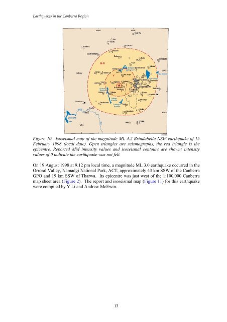
<strong>Earthquakes</strong> <strong>in</strong> <strong>the</strong> <strong>Canberra</strong> <strong>Region</strong>Figure 10. Isoseismal map of <strong>the</strong> magnitude ML 4.2 Br<strong>in</strong>dabella NSW earthquake of 15February 1998 (local date). Open triangles are seismographs, <strong>the</strong> red triangle is <strong>the</strong>epicentre. Reported MM <strong>in</strong>tensity values and isoseismal contours are shown; <strong>in</strong>tensityvalues of 0 <strong>in</strong>dicate <strong>the</strong> earthquake was not felt.On 19 August 1998 at 9.12 pm local time, a magnitude ML 3.0 earthquake occurred <strong>in</strong> <strong>the</strong>Orroral Valley, Namadgi National Park, ACT, approximately 43 km SSW of <strong>the</strong> <strong>Canberra</strong>GPO and 19 km SSW of Tharwa. Its epicentre was just west of <strong>the</strong> 1:100,000 <strong>Canberra</strong>map sheet area (Figure 2). The report and isoseismal map (Figure 11) for this earthquakewere compiled by Y Li and Andrew McEw<strong>in</strong>.13


