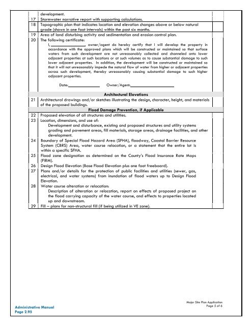
Major Site Plan Design Standards ChecklistThe table below depicts the design standards of the major site plan application. Please make sure toinclude all applicable listed items to ensure all appropriate standards are reviewed.Major Site PlanDesign Standards ChecklistDate Received: ___________________TRC Date: _________________Project Name: _________________________________________________________________________Applicant/Property Owner: ______________________________________________________________Site Plan Design Standards ChecklistGeneral1 Property owner name, address, phone number, and e-mail address.2 Site address and parcel identification number.3 North arrow and scale to be 1” = 100’ or larger.4 Vicinity map showing property’s general location in relation to streets, railroads, andwaterways.5 Existing zoning classification and zoning setback lines of the property.6 Scaled drawing showing existing and proposed site features:Property lines, acreage, adjacent use types, streets (right-of-ways), easements, buildingsand accessory structures (including square feet and use), parking layout, vehicular useareas, driveways (including opposing driveways), loading spaces, refuse collection facilities(dumpsters), outdoor storage areas, ground based utility equipment, fences and walls, andsidewalks and pedestrian circulation.And location and size of existing and proposed infrastructure:Water mains (including and water taps), water meter details, backflow prevention details,wells, sewer mains or on-site septic systems (including repair area), electrical service, firehydrants, detail of fire apparatus access to buildings, and any other public utility within alladjacent public right-of-ways and easements.7 Approximate location of all designated Areas of Environmental Concern or other such areaswhich are environmentally sensitive on the property, such as Maritime Forest, CAMA, 404, or401 wetlands as defined by the appropriate agency.8 Sight distance triangles.9 Proposed common areas, open space set-asides, and required buffers.Landscape Plan10 All existing and proposed planting areas and vegetation that will be used to comply with thelandscaping requirements, including the species, caliper, and spacing of all vegetation.11 Existing and proposed physical barriers to be used to comply with the bufferyard andscreening requirements.12 Heritage tree inventory and proposed tree protection zones.13 Adjoining property lines, zoning, and names and address of adjoining propertyowners.Exterior Lighting Plan14 Location, height, and type of all proposed exterior lighting including but not limited to site,street, building, and security lighting.15 Footcandle measurements of the entire site including lot lines, or light fixture documentationwhen minimal lighting is proposed.Stormwater Management Plan16 Location of storm drainage patterns, BMP’s and drainage infrastructure intended to serve the<strong>Administrative</strong> <strong>Manual</strong>Page 2.94Major Site Plan ApplicationPage 4 of 6
development.17 Stormwater narrative report with supporting calculations.18 Topographic plan that indicates location and elevation changes above or below naturalgrade (shown in one foot intervals) within the past six months.19 Area of land disturbing activity and sedimentation and erosion control plan.20 The following certificate:I, , owner/agent do hereby certify that I will develop the property inaccordance with the approved plans which will be constructed or maintained so that surfacewaters from such development are not unreasonably collected and channeled onto loweradjacent properties at such locations or at such volumes as to cause substantial damage to suchlower adjacent properties. In addition, the development will be constructed or maintained sothat it will not unreasonably impede the natural flow of water from higher or adjacent propertiesacross such development, thereby unreasonably causing substantial damage to such higheradjacent properties.Date:Owner/Agent:Architectural Elevations21 Architectural drawings and/or sketches illustrating the design, character, height, and materialsof the proposed buildings.Flood Damage Prevention, if Applicable22 Proposed elevation of all structures and utilities.23 Location, dimensions, and use of:Development and disturbance, existing and proposed structures and utility systemsgrading and pavement areas, fill materials, storage areas, drainage facilities, and otherdevelopment.24 Boundary of Special Flood Hazard Area (SFHA), floodway, Coastal Barrier ResourceSystem (CBRS) Area, water course relocation, or a statement that the entire lot iswithin a specific SFHA.25 Flood zone designation as determined on the <strong>County</strong>’s Flood Insurance Rate Maps(FIRM).26 Design Flood Elevation (Base Flood Elevation plus one foot freeboard).27 Plans and/or details for the protection of public facilities and utilities (sewer, gas,electrical, and water systems) from inundation of flood waters up to Design FloodElevation.28 Water course alteration or relocation:Description of alteration or relocation, report on effects of proposed project onthe flood carrying capacity of the water course, and effects to properties locatedup and downstream.29 Fill – plans for non-structural fill (if being utilized in VE zone).<strong>Administrative</strong> <strong>Manual</strong>Page 2.95Major Site Plan ApplicationPage 5 of 6