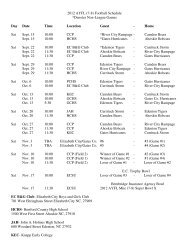
UDO Administrative Manual - Currituck County Government
UDO Administrative Manual - Currituck County Government
UDO Administrative Manual - Currituck County Government

You also want an ePaper? Increase the reach of your titles
YUMPU automatically turns print PDFs into web optimized ePapers that Google loves.
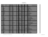
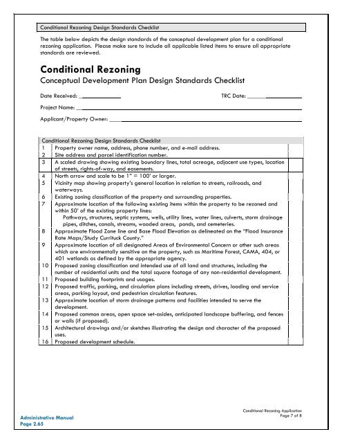
Conditional Rezoning Design Standards ChecklistThe table below depicts the design standards of the conceptual development plan for a conditionalrezoning application. Please make sure to include all applicable listed items to ensure all appropriatestandards are reviewed.Conditional RezoningConceptual Development Plan Design Standards ChecklistDate Received: _Project Name: __Applicant/Property Owner: ____TRC Date: ______Conditional Rezoning Design Standards Checklist1 Property owner name, address, phone number, and e-mail address.2 Site address and parcel identification number.3 A scaled drawing showing existing boundary lines, total acreage, adjacent use types, locationof streets, rights-of-way, and easements.4 North arrow and scale to be 1” = 100’ or larger.5 Vicinity map showing property’s general location in relation to streets, railroads, andwaterways.6 Existing zoning classification of the property and surrounding properties.7 Approximate location of the following existing items within the property to be rezoned andwithin 50’ of the existing property lines:Pathways, structures, septic systems, wells, utility lines, water lines, culverts, storm drainagepipes, ditches, canals, streams, wooded areas, ponds, and cemeteries.8 Approximate Flood Zone line and Base Flood Elevation as delineated on the “Flood InsuranceRate Maps/Study <strong>Currituck</strong> <strong>County</strong>.”9 Approximate location of all designated Areas of Environmental Concern or other such areaswhich are environmentally sensitive on the property, such as Maritime Forest, CAMA, 404, or401 wetlands as defined by the appropriate agency.10 Proposed zoning classification and intended use of all land and structures, including thenumber of residential units and the total square footage of any non-residential development.11 Proposed building footprints and usages.12 Proposed traffic, parking, and circulation plans including streets, drives, loading and serviceareas, parking layout, and pedestrian circulation features.13 Approximate location of storm drainage patterns and facilities intended to serve thedevelopment.14 Proposed common areas, open space set-asides, anticipated landscape buffering, and fencesor walls (if proposed).15 Architectural drawings and/or sketches illustrating the design and character of the proposeduses.16 Proposed development schedule.<strong>Administrative</strong> <strong>Manual</strong>Page 2.65Conditional Rezoning ApplicationPage 7 of 8