UDO Administrative Manual - Currituck County Government
UDO Administrative Manual - Currituck County Government
UDO Administrative Manual - Currituck County Government

Create successful ePaper yourself
Turn your PDF publications into a flip-book with our unique Google optimized e-Paper software.
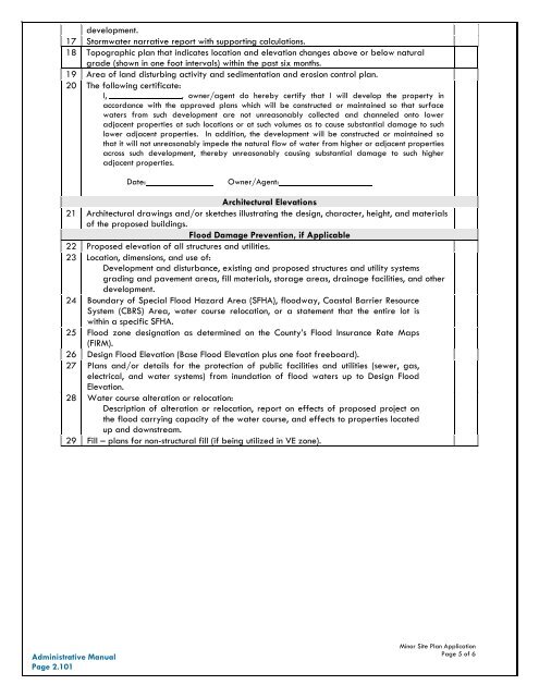
development.17 Stormwater narrative report with supporting calculations.18 Topographic plan that indicates location and elevation changes above or below naturalgrade (shown in one foot intervals) within the past six months.19 Area of land disturbing activity and sedimentation and erosion control plan.20 The following certificate:I, , owner/agent do hereby certify that I will develop the property inaccordance with the approved plans which will be constructed or maintained so that surfacewaters from such development are not unreasonably collected and channeled onto loweradjacent properties at such locations or at such volumes as to cause substantial damage to suchlower adjacent properties. In addition, the development will be constructed or maintained sothat it will not unreasonably impede the natural flow of water from higher or adjacent propertiesacross such development, thereby unreasonably causing substantial damage to such higheradjacent properties.Date:Owner/Agent:Architectural Elevations21 Architectural drawings and/or sketches illustrating the design, character, height, and materialsof the proposed buildings.Flood Damage Prevention, if Applicable22 Proposed elevation of all structures and utilities.23 Location, dimensions, and use of:Development and disturbance, existing and proposed structures and utility systemsgrading and pavement areas, fill materials, storage areas, drainage facilities, and otherdevelopment.24 Boundary of Special Flood Hazard Area (SFHA), floodway, Coastal Barrier ResourceSystem (CBRS) Area, water course relocation, or a statement that the entire lot iswithin a specific SFHA.25 Flood zone designation as determined on the <strong>County</strong>’s Flood Insurance Rate Maps(FIRM).26 Design Flood Elevation (Base Flood Elevation plus one foot freeboard).27 Plans and/or details for the protection of public facilities and utilities (sewer, gas,electrical, and water systems) from inundation of flood waters up to Design FloodElevation.28 Water course alteration or relocation:Description of alteration or relocation, report on effects of proposed project onthe flood carrying capacity of the water course, and effects to properties locatedup and downstream.29 Fill – plans for non-structural fill (if being utilized in VE zone).<strong>Administrative</strong> <strong>Manual</strong>Page 2.101Minor Site Plan ApplicationPage 5 of 6