- Page 1: HDS-5, HDS-7,HDS-5m & HDS-7mOperati
- Page 4 and 5: ContentsPalette....................
- Page 7: IntroductionLowrance HDS-5/7 & HDS
- Page 10 and 11: Getting StartedSelecting Chart Data
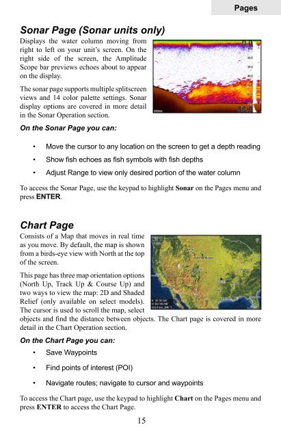
- Page 12 and 13: PagesPagesWith Chart selected, unit
- Page 14 and 15: PagesMove or Placing a GaugeThe Mov
- Page 18 and 19: PagesRadar Page (optional)Displays
- Page 20 and 21: PagesTo edit gauge display:1. Use t
- Page 22: PagesChange LayoutControls the gaug
- Page 25 and 26: PagesInfo selected as combodisplay
- Page 27 and 28: PagesMoving panel cursor left/right
- Page 30 and 31: SonarColorlineDistinguishes strong
- Page 32 and 33: SonarCustom — Upper and Lower Lim
- Page 34 and 35: SonarTemperature GraphUses a red li
- Page 36 and 37: SonarFilenameSave toBytesLog All Ch
- Page 38 and 39: ChartChart OperationPoint of Intere
- Page 40 and 41: ChartOrientationChart detailLook ah
- Page 42 and 43: ChartWaypoint nameWaypoint iconDist
- Page 44 and 45: ChartEditing a Waypoint on the Char
- Page 46 and 47: ChartRoutesRoutes make it easier to
- Page 48 and 49: ChartRoutes screen menuFrom the Rou
- Page 50 and 51: ChartTrailsA trail is a record of t
- Page 52 and 53: ChartTrail line Color optionsYou ca
- Page 54 and 55: ChartMap OrientationTo change Chart
- Page 56 and 57: ChartChart page Icons, Tides and Cu
- Page 58 and 59: ChartNavionics Settings menuUse to
- Page 60 and 61: RadarRadar Operation (optional)Rang
- Page 62 and 63: RadarAdjust menu optionsGainSea Clu
- Page 64 and 65: RadarCenterLook AheadOffsetPosition
- Page 66 and 67:
RadarData BoxTurns on/off on screen
- Page 68 and 69:
SettingsSettings MenuThe Settings M
- Page 70 and 71:
SettingsDatumA model of the earth
- Page 72 and 73:
SettingsScreen CaptureSaves images
- Page 74 and 75:
SettingsTo adjust cursor settings:1
- Page 76 and 77:
SettingsTime PeriodControls how muc
- Page 78 and 79:
SettingsHeading Extension lineTo us
- Page 80 and 81:
SettingsSonar Settings (HDS-5 &7)Th
- Page 82 and 83:
SettingsFishing ModesEnhances the p
- Page 84 and 85:
SettingsBefore setting keel offset,
- Page 86 and 87:
SettingsTo select a Temperature Ave
- Page 88 and 89:
SettingsBlack Color PaletteWhite Co
- Page 90 and 91:
SettingsTo set T/M or R:1. Press me
- Page 92 and 93:
SettingsTo cancel individual target
- Page 94 and 95:
SettingsInstallation Adjustment Men
- Page 96 and 97:
SettingsAntenna HeightAntenna heigh
- Page 98 and 99:
SettingsFuelUsed to input fuel data
- Page 100 and 101:
SettingsFuel UsedData information s
- Page 102 and 103:
SettingsAlarmsThis unit has alarms
- Page 104 and 105:
SettingsNetworkControls network con
- Page 106 and 107:
SettingsTo select a scope:1. Highli
- Page 108 and 109:
SettingsTo configure device locatio
- Page 110 and 111:
SettingsNMEA 0183 OutputControls NM
- Page 112 and 113:
SettingsSimulatorAccesses all simul
- Page 114 and 115:
SettingsRouteAllows you to select a
- Page 116 and 117:
Unit CareUnit CareCleaning the scre
- Page 118 and 119:
Troubleshootingbubbles. (See the In
- Page 120 and 121:
Troubleshootingto 60ft or whatever
- Page 122 and 123:
TroubleshootingCards not Read by Un
- Page 124 and 125:
TroubleshootingHighlight FORCE STAT
- Page 126 and 127:
IndexDelete data files 22Delete son
- Page 128 and 129:
IndexSonar manual mode 79Sonar menu
- Page 130:
Databases Limited Warranty"We", "ou