History of the Shepherd to Sabine project area - Buffalo Bayou Park
History of the Shepherd to Sabine project area - Buffalo Bayou Park
History of the Shepherd to Sabine project area - Buffalo Bayou Park

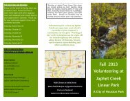
Create successful ePaper yourself
Turn your PDF publications into a flip-book with our unique Google optimized e-Paper software.
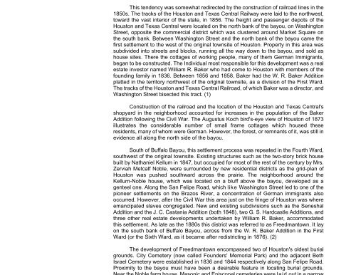
This tendency was somewhat redirected by <strong>the</strong> construction <strong>of</strong> railroad lines in <strong>the</strong>1850s. The tracks <strong>of</strong> <strong>the</strong> Hous<strong>to</strong>n and Texas Central Railway were laid <strong>to</strong> <strong>the</strong> northwest,<strong>to</strong>ward <strong>the</strong> vast interior <strong>of</strong> <strong>the</strong> state, in 1856. The freight and passenger depots <strong>of</strong> <strong>the</strong>Hous<strong>to</strong>n and Texas Central were located on <strong>the</strong> north bank <strong>of</strong> <strong>the</strong> bayou, on Washing<strong>to</strong>nStreet, opposite <strong>the</strong> commercial district which was clustered around Market Square on<strong>the</strong> south bank. Between Washing<strong>to</strong>n Street and <strong>the</strong> north bank <strong>of</strong> <strong>the</strong> bayou came <strong>the</strong>first settlement <strong>to</strong> <strong>the</strong> west <strong>of</strong> <strong>the</strong> original <strong>to</strong>wnsite <strong>of</strong> Hous<strong>to</strong>n. Property in this <strong>area</strong> wassubdivided in<strong>to</strong> streets and blocks, running all <strong>the</strong> way down <strong>to</strong> <strong>the</strong> bayou, and sold ashouse sites. There <strong>the</strong> cottages <strong>of</strong> working people, many <strong>of</strong> <strong>the</strong>m German Immigrants,began <strong>to</strong> be constructed. The Individual most responsible for this development was a realestate inves<strong>to</strong>r named William R. Baker who had come <strong>to</strong> Hous<strong>to</strong>n with members <strong>of</strong> <strong>the</strong>founding family in 1836. Between 1856 and 1858, Baker had <strong>the</strong> W. R. Baker Additionplatted in <strong>the</strong> terri<strong>to</strong>ry northwest <strong>of</strong> <strong>the</strong> original <strong>to</strong>wnsite, as a division <strong>of</strong> <strong>the</strong> First Ward.The tracks <strong>of</strong> <strong>the</strong> Hous<strong>to</strong>n and Texas Central Railroad, <strong>of</strong> which Baker was a direc<strong>to</strong>r, andWashing<strong>to</strong>n Street bisected this tract. (1)Construction <strong>of</strong> <strong>the</strong> railroad and <strong>the</strong> location <strong>of</strong> <strong>the</strong> Hous<strong>to</strong>n and Texas Central'sshopyard in <strong>the</strong> neighborhood accounted for increases in <strong>the</strong> population <strong>of</strong> <strong>the</strong> BakerAddition following <strong>the</strong> Civil War. The Augustus Koch bird's-eye view <strong>of</strong> Hous<strong>to</strong>n <strong>of</strong> 1873illustrates <strong>the</strong> considerable number <strong>of</strong> small frame cottages which housed <strong>the</strong>seresidents, many <strong>of</strong> whom were German. However, <strong>the</strong> forest, or remnants <strong>of</strong> it, was still inevidence all along <strong>the</strong> north side <strong>of</strong> <strong>the</strong> bayou.South <strong>of</strong> <strong>Buffalo</strong> <strong>Bayou</strong>, this settlement process was repeated in <strong>the</strong> Fourth Ward,southwest <strong>of</strong> <strong>the</strong> original <strong>to</strong>wnsite. Existing structures such as <strong>the</strong> two-s<strong>to</strong>ry brick housebuilt by Nathaniel Kellum in 1847, but occupied for most <strong>of</strong> <strong>the</strong> rest <strong>of</strong> <strong>the</strong> century by Mrs.Zerviah Metcalf Noble, were surrounded by new residential districts as <strong>the</strong> grid-plan <strong>of</strong>Hous<strong>to</strong>n was pushed southward across <strong>the</strong> prairie. The neighborhood around <strong>the</strong>Kellurn-Noble house, which was located on a bluff above <strong>the</strong> bayou, developed as agenteel one. Along <strong>the</strong> San Felipe Road, which like Washing<strong>to</strong>n Street led <strong>to</strong> one <strong>of</strong> <strong>the</strong>pioneer settlements on <strong>the</strong> Brazos River, a concentration <strong>of</strong> German immigrants alsooccurred. However, after <strong>the</strong> Civil War this <strong>area</strong> just on <strong>the</strong> fringe <strong>of</strong> Hous<strong>to</strong>n was whereemancipated slaves congregated. New and existing subdivisions such as <strong>the</strong> SeneshalAddition and <strong>the</strong> J. C. Castania Addition (both 1848), two G. S. Hardcastle Additions, andthree o<strong>the</strong>r real estate developments undertaken by William R. Baker, accommodatedthis settlement. As late as <strong>the</strong> 1880s this district was referred <strong>to</strong> as Freedman<strong>to</strong>wn. It layon <strong>the</strong> south bank <strong>of</strong> <strong>Buffalo</strong> <strong>Bayou</strong>, across from <strong>the</strong> W. R. Baker Addition in <strong>the</strong> FirstWard (or <strong>the</strong> Sixth Ward, as it became after redistricting in 1876). (2)The development <strong>of</strong> Freedman<strong>to</strong>wn encompassed two <strong>of</strong> Hous<strong>to</strong>n's oldest burialgrounds. City Cemetery (now called Founders' Memorial <strong>Park</strong>) and <strong>the</strong> adjacent BethIsrael Cemetery were established in 1836 and 1844 respectively along San Felipe Road.Proximity <strong>to</strong> <strong>the</strong> bayou must have been a desirable feature in locating burial grounds.