

POWER GRAPHIC Engineering Surveyor Programs
POWER GRAPHIC Engineering Surveyor Programs
POWER GRAPHIC Engineering Surveyor Programs

You also want an ePaper? Increase the reach of your titles
YUMPU automatically turns print PDFs into web optimized ePapers that Google loves.
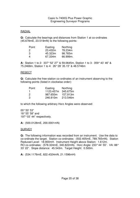
Casio fx-7400G Plus Power Graphic<strong>Engineering</strong> <strong>Surveyor</strong> <strong>Programs</strong>RADIALQ: Calculate the bearings and distances from Station 1 at co-ordinates(45.678mE, 23.519mN) to the following points:Point Easting Northing2 23.432m 78.234m3 45.323m 98.765m4 67.334m 66.999m.A: Station 1 to 2: 337° 52’ 27” & 59.0645m, Station 1 to 3: 359° 43’ 46” &75.2468m, Station 1 to 4: 26° 28’ 35.15” & 48.5746mRESECTQ: Calculate the free-station co-ordinates of an instrument observing to thefollowing points (listed in clockwise order):Point Easting Northing1 1123.457m 345.675m2 987.650m 157,913m3 246.810m 213.546mto which the following arbitrary Horz Angles were observed:00° 50’ 53”18° 55’ 58” and197° 03’ 44” respectively.A: (500.0128mE, 200.0001mN)SURVEYQ: The following information was recorded from an instrument. Use the data toco-ordinate the target. Station co-ordinates: (502.405mE, 789.765mN). StationReduced Level: 18.900mH. Instrument Height above Station: 1.612m.RO co-ordinates: (578.324mE, 340.822mN). Horz Angle: 233° 44’ 55”. VA: 88°33’ 22”. Slope distance: 45.543m. Target Height: 0.500m.A: (534.1176mE, 822.4324mN, 21.1596mH)Page 35 of 38


