Transformations and OSGM02 user guide - Leica Geosystems
Transformations and OSGM02 user guide - Leica Geosystems
Transformations and OSGM02 user guide - Leica Geosystems
- No tags were found...

You also want an ePaper? Increase the reach of your titles
YUMPU automatically turns print PDFs into web optimized ePapers that Google loves.
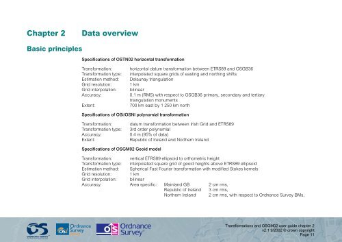
Chapter 2Data overviewBasic principlesSpecifications of OSTN02 horizontal transformationTransformation:Transformation type:Estimation method:Grid resolution:Grid interpolation:Accuracy:Extent:horizontal datum transformation between ETRS89 <strong>and</strong> OSGB36interpolated square grids of easting <strong>and</strong> northing shiftsDelaunay triangulation1 kmbilinear0.1 m (RMS) with respect to OSGB36 primary, secondary <strong>and</strong> tertiarytriangulation monuments700 km east by 1 250 km northSpecifications of OSi/OSNI polynomial transformationTransformation:Transformation type:Accuracy:Extent:datum transformation between Irish Grid <strong>and</strong> ETRS893rd order polynomial0.4 m (95% of data)Republic of Irel<strong>and</strong> <strong>and</strong> Northern Irel<strong>and</strong>Specifications of <strong>OSGM02</strong> Geoid modelTransformation: vertical ETRS89 ellipsoid to orthometric heightTransformation type: interpolated square grid of geoid heights above ETRS89 ellipsoidEstimation method: Spherical Fast Fourier transformation with modified Stokes kernelsGrid resolution: 1 kmGrid interpolation: bilinearAccuracy: Area specific: Mainl<strong>and</strong> GB 2 cm rms,Republic of Irel<strong>and</strong> 3 cm rms,Northern Irel<strong>and</strong> 2 cm rms, with respect to Ordnance Survey BMs,<strong>Transformations</strong> <strong>and</strong> <strong>OSGM02</strong> <strong>user</strong> <strong>guide</strong> chapter 2v2.1 9/2002 © crown copyrightPage 11