Transformations and OSGM02 user guide - Leica Geosystems
Transformations and OSGM02 user guide - Leica Geosystems
Transformations and OSGM02 user guide - Leica Geosystems
- No tags were found...
Create successful ePaper yourself
Turn your PDF publications into a flip-book with our unique Google optimized e-Paper software.
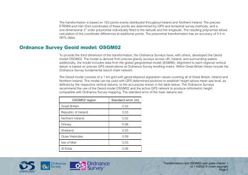
The transformation is based on 183 points evenly distributed throughout Irel<strong>and</strong> <strong>and</strong> Northern Irel<strong>and</strong>. The preciseETRS89 <strong>and</strong> Irish Grid coordinates of these points are determined by GPS <strong>and</strong> terrestrial survey methods, <strong>and</strong> aone-dimensional 3 rd order polynomial individually fitted to the latitude <strong>and</strong> the longitude. The resulting polynomial allowscalculation of the coordinate differences at additional points. The polynomial transformation has an accuracy of 0.4 m(95% data).Ordnance Survey Geoid model: <strong>OSGM02</strong>To provide the third dimension of the transformation, the Ordnance Surveys have, with others, developed the Geoidmodel <strong>OSGM02</strong>. The model is derived from precise gravity surveys across UK, Irel<strong>and</strong>, <strong>and</strong> surrounding waters;additionally, the model includes data from the global geopotential model (EGM96). Alignment to each regional verticaldatum is based on precise GPS observations at Ordnance Survey levelling marks. Within Great Britain these include theOrdnance Survey fundamental bench mark network.The Geoid model consists of a 1 km grid with geoid-ellipsoid separation values covering all of Great Britain, Irel<strong>and</strong> <strong>and</strong>Northern Irel<strong>and</strong>. This model can be used with GPS determined positions to establish height above mean sea level, asdefined by the respective vertical datums, to the accuracies shown in the table below. The Ordnance Surveysrecommend the use of the Geoid model <strong>OSGM02</strong> <strong>and</strong> the active GPS network to produce orthometric heightcompatible with Ordnance Survey mapping. The st<strong>and</strong>ard error of the main datums are:<strong>OSGM02</strong> regionSt<strong>and</strong>ard error (m)Great Britain 0.02Republic of Irel<strong>and</strong> 0.03Northern Irel<strong>and</strong> 0.02Orkney 0.08Shetl<strong>and</strong> 0.03Outer Hebrides 0.09Isle of Man 0.03St Kilda 0.06<strong>Transformations</strong> <strong>and</strong> <strong>OSGM02</strong> <strong>user</strong> <strong>guide</strong> chapter 1v2.1 9/2002 © crown copyrightPage 8


