Transformations and OSGM02 user guide - Leica Geosystems
Transformations and OSGM02 user guide - Leica Geosystems
Transformations and OSGM02 user guide - Leica Geosystems
- No tags were found...

You also want an ePaper? Increase the reach of your titles
YUMPU automatically turns print PDFs into web optimized ePapers that Google loves.
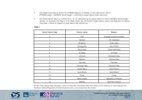
4 the height of the Geoid above the ETRS89 ellipsoid, in metres, at the intersection, that isETRS89 height – <strong>OSGM02</strong> Geoid height = orthometric height above mean sea level.5 the Geoid datum flag is a number from 1 to 14, representing the geoid datum to which <strong>OSGM02</strong> Geoid heightrelates, for example, this flag is 13 for Malin Head, the orthometric height datum used in the Republic of Irel<strong>and</strong>.See table 1 below for details of other datum flag references.Table 1Geoid datum flag Datum name Region0 N/A Outside model boundary1 Newlyn UK mainl<strong>and</strong>2 St Marys Scilly Isles3 Douglas02 Isle of Man4 Stornoway Outer Hebrides5 St Kilda St Kilda6 Lerwick Shetl<strong>and</strong> Isles7 Newlyn Orkney Isles8 Fair Isle Fair Isle9 Flannan Isles Flannan Isles10 North Rona North Rona11 Sule Skerry Sule Skerry12 Foula Foula13 Malin Head Republic of Irel<strong>and</strong>14 Belfast Northern Irel<strong>and</strong>NOTE: If the datum flag indicates a zero (0) then the coordinate falls more than 10 km offshore or 2 km beyond theNorthern Irel<strong>and</strong>/Republic of Irel<strong>and</strong> border <strong>and</strong> is not covered by the model.<strong>Transformations</strong> <strong>and</strong> <strong>OSGM02</strong> <strong>user</strong> <strong>guide</strong> chapter 2v2.1 9/2002 © crown copyrightPage 17