Transformations and OSGM02 user guide - Leica Geosystems
Transformations and OSGM02 user guide - Leica Geosystems
Transformations and OSGM02 user guide - Leica Geosystems
- No tags were found...

You also want an ePaper? Increase the reach of your titles
YUMPU automatically turns print PDFs into web optimized ePapers that Google loves.
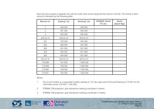
Each record occupies a separate line with the south-west corner being the first record in the file. The format of eachrecord is indicated by the following table:Record no 1 Easting 2 (m) Northing 3 (m) <strong>OSGM02</strong> GeoidHt 4 (m)1 400 000 500 0002 401 000 500 0003 402 000 500 000<strong>and</strong> so on <strong>and</strong> so on <strong>and</strong> so on351 750 000 500 000352 400 000 501 000353 401 000 501 000354 402 000 501 000355 403 000 501 000<strong>and</strong> so on <strong>and</strong> so on <strong>and</strong> so on175 848 747 000 1 000 000175 849 748 000 1 000 000175 850 749 000 1 000 000175 851 750 000 1 000 000Geoiddatum flag 5Where:1 the record number is a sequential number starting at 1 for the origin point (0,0) <strong>and</strong> finishing at 175 851 for thenorth-east corner (750 000, 1 000 000).2 ETRS89, ITM projection, grid intersection easting coordinate in metres.3 ETRS89, ITM projection, grid intersection northing coordinate in metres.<strong>Transformations</strong> <strong>and</strong> <strong>OSGM02</strong> <strong>user</strong> <strong>guide</strong> chapter 2v2.1 9/2002 © crown copyrightPage 16