Transformations and OSGM02 user guide - Leica Geosystems
Transformations and OSGM02 user guide - Leica Geosystems
Transformations and OSGM02 user guide - Leica Geosystems
- No tags were found...
You also want an ePaper? Increase the reach of your titles
YUMPU automatically turns print PDFs into web optimized ePapers that Google loves.
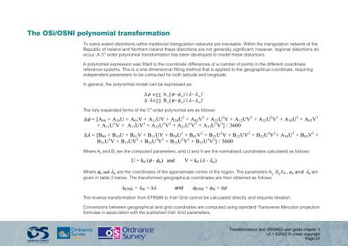
The OSi/OSNI polynomial transformationTo some extent distortions within traditional triangulation networks are inevitable. Within the triangulation network of theRepublic of Irel<strong>and</strong> <strong>and</strong> Northern Irel<strong>and</strong> these distortions are not generally significant; however, regional distortions dooccur. A 3 rd order polynomial transformation has been developed to model these distortions.A polynomial expression was fitted to the coordinate differences of a number of points in the different coordinatereference systems. This is a one-dimensional fitting method that is applied to the geographical coordinate, requiringindependent parameters to be computed for both latitude <strong>and</strong> longitude.In general, the polynomial model can be expressed as:∆φ = ∑∑ Α ij(φ−φ m) i (λ−λ m) j∆ λ=∑∑ Β ij(φ−φ m) i (λ−λ m) jThe fully exp<strong>and</strong>ed forms of the 3 rd order polynomial are as follows:∆φ = [A 00 + A 10 U + A 01 V + A 11 UV + A 20 U 2 + A 02 V 2 + A 21 U 2 V + A 12 UV 2 + A 22 U 2 V 2 + A 30 U 3 + A 03 V 3+ A 31 U 3 V + A 13 UV 3 + A 32 U 3 V 2 + A 23 U 2 V 3 + A 33 U 3 V 3 ] / 3600∆λ = [B 00 + B 10 U + B 01 V + B 11 UV + B 20 U 2 + B 02 V 2 + B 21 U 2 V + B 12 UV 2 + B 22 U 2 V 2 + A 30 U 3 + B 03 V 3 +B 31 U 3 V + B 13 UV 3 + B 32 U 3 V 2 + B 23 U 2 V 3 + B 33 U 3 V 3 ] / 3600Where A ij<strong>and</strong> B ijare the computed parameters, <strong>and</strong> U <strong>and</strong> V are the normalised coordinates calculated as follows:U = k 0 (φ - φ m ) <strong>and</strong> V = k 0 (λ - λ m )Where φ m <strong>and</strong> λ m are the coordinates of the approximate centre of the region. The parameters A ij, B ij,K 0 , φ m <strong>and</strong> λ m aregiven in table 2 below. The transformed geographical coordinates are then obtained as follows:λ ETRS = λ IG + ∆λ <strong>and</strong> φ ETRS = φ IG + ∆φThe reverse transformation from ETRS89 to Irish Grid cannot be calculated directly <strong>and</strong> requires iteration.Conversions between geographical <strong>and</strong> grid coordinates are computed using st<strong>and</strong>ard Transverse Mercator projectionformulae in association with the published Irish Grid parameters.<strong>Transformations</strong> <strong>and</strong> <strong>OSGM02</strong> <strong>user</strong> <strong>guide</strong> chapter 3v2.1 9/2002 © crown copyrightPage 23


