Transformations and OSGM02 user guide - Leica Geosystems
Transformations and OSGM02 user guide - Leica Geosystems
Transformations and OSGM02 user guide - Leica Geosystems
- No tags were found...

Create successful ePaper yourself
Turn your PDF publications into a flip-book with our unique Google optimized e-Paper software.
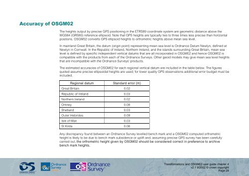
Accuracy of <strong>OSGM02</strong>The heights output by precise GPS positioning in the ETRS89 coordinate system are geometric distance above theWGS84 (GRS80) reference ellipsoid. Note that GPS heights are typically two to three times less precise than horizontalpositions. <strong>OSGM02</strong> converts GPS ellipsoid heights to orthometric heights above mean sea level.In mainl<strong>and</strong> Great Britain, the datum (origin point) representing mean sea level is Ordnance Datum Newlyn, defined atNewlyn in Cornwall. In the Republic of Irel<strong>and</strong>, Northern Irel<strong>and</strong>, <strong>and</strong> the isl<strong>and</strong>s surrounding Great Britain, mean sealevel is defined by specific independent vertical datums that are all incorporated in <strong>OSGM02</strong> <strong>and</strong> hence <strong>OSGM02</strong> iscompatible with the products from each of the Ordnance Surveys. Other geoid models may give mean sea level heightsthat are incompatible with the Ordnance Surveys' products.The estimated accuracies of <strong>OSGM02</strong> for each regional vertical datum are included in the table below. The figuresquoted assume precise ellipsoidal heights are used; for lower quality GPS observations additional error budget must beincluded.Regional datumSt<strong>and</strong>ard error (m)Great Britain 0.02Republic of Irel<strong>and</strong> 0.03Northern Irel<strong>and</strong> 0.02Orkney 0.08Shetl<strong>and</strong> 0.03Outer Hebrides 0.09Isle of Man 0.03St Kilda 0.06Any discrepancy found between an Ordnance Survey levelled bench mark <strong>and</strong> a <strong>OSGM02</strong> computed orthometricheight is likely to be due to bench mark subsidence or uplift <strong>and</strong>, assuming precise GPS survey has been carefullycarried out, the orthometric height given by <strong>OSGM02</strong> should be considered correct in preference to archivebench mark heights.<strong>Transformations</strong> <strong>and</strong> <strong>OSGM02</strong> <strong>user</strong> <strong>guide</strong> chapter 4v2.1 9/2002 © crown copyrightPage 28