FM 3-25.26 MAP READING AND LAND NAVIGATION
FM 3-25.26 MAP READING AND LAND NAVIGATION
FM 3-25.26 MAP READING AND LAND NAVIGATION

Create successful ePaper yourself
Turn your PDF publications into a flip-book with our unique Google optimized e-Paper software.
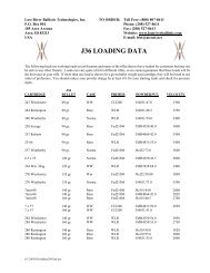
same procedure is followed using the tick marks along the top and bottom edges of the map.e. After the parallels and meridians have been drawn, the geographic interval (angular distance between twoadjacent lines) must be determined. Examination of the values given at the tick marks gives the interval. Formost maps of scale 1:25,000, the interval is 2'30". For the Columbus map and most maps of scale 1:50,000, it is5'00". The geographic coordinates of a point are found by dividing the sides of the geographic square in whichthe point is located into the required number of equal parts. If the geographic interval is 5'00" and the location ofa point is required to the nearest second, each side of the geographic square must be divided into 300 equal parts(5'00" = 300"), each of which would have a value of one second. Any scale or ruler that has 300 equal divisionsand is as long as or longer than the spacing between the lines may be used.f. The following steps will determine the geographic coordinates of Wilkinson Cemetery (northwest of thetown of Cusseta) on the Columbus map.(1) Draw the parallels and meridians on the map that encloses the area around the cemetery.(2) Determine the values of the parallels and meridians where the point falls.Latitude 32° 15'00" and 32° 20'00".Longitude 84° 45'00" and 84° 50'00".(3) Determine the geographic interval (5'00" = 300").(4) Select a scale that has 300 small divisions or multiples thereof (300 divisions, one second each; 150divisions, two seconds each; 75 divisions, four seconds each, and so forth).(5) To determine the latitude—(a) Place the scale with the 0 of the scale on the latitude of the lowest number value (32° 15'00")and the 300 of the scale on the highest numbered line (32° 20'00") (1, Figure 4-4).(b) While keeping the 0 and 300 on the two lines, slide the scale (2, Figure 4-4) along the parallelsuntil the Wilkinson Cemetery symbol is along the edge of the numbered scale.(c) Read the number of seconds from the scale (3, Figure 4-4), about 246.(d) Convert the number of seconds to minutes and seconds (246" = 4'06") and add to the value ofthe lower numbered line (32° 15'00" + 4'06" = 32° 19'06") (4, Figure 4-4).RESULTS:• The latitude is 32° 19'06", but this is not enough.• The latitude 32° 19'06" could be either north or south of the equator, so the letter N or S mustbe added to the latitude. To determine whether it is N or S, look at the latitude values at theedge of the map and find the direction in which they become larger. If they are larger goingnorth, use N; if they are larger going south, use S.• The latitude for the cemetery is 32° 19'06"N.