Deltas on the move; Making deltas cope with the effects of climate c
Deltas on the move; Making deltas cope with the effects of climate c
Deltas on the move; Making deltas cope with the effects of climate c
- No tags were found...

Create successful ePaper yourself
Turn your PDF publications into a flip-book with our unique Google optimized e-Paper software.
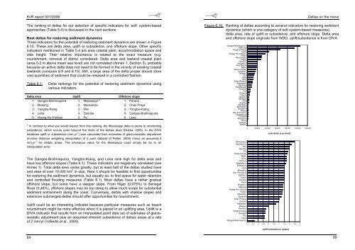
KvR report 001/2006The ranking <strong>of</strong> <strong>deltas</strong> for our selecti<strong>on</strong> <strong>of</strong> specific indicators for ‘s<strong>of</strong>t’ system-basedapproaches (Table 5.4) is discussed in <strong>the</strong> next secti<strong>on</strong>s.Best <strong>deltas</strong> for restoring sediment dynamicsThree indicators for <strong>the</strong> potential <strong>of</strong> restoring sediment dynamics are shown in Figure6.10. These are delta area, uplift or subsidence, and <strong>of</strong>fshore slope. O<strong>the</strong>r specificindicators menti<strong>on</strong>ed in Table 5.4 are area coastal plain, accommodati<strong>on</strong> space anddike height. Their relative importance is related to <strong>the</strong> exact measure (e.g.nourishment, removal <strong>of</strong> dams) c<strong>on</strong>sidered. Delta area and lowland coastal plain(area 0-2 m above mean sea level) are not correlated (Annex 1, Secti<strong>on</strong> 3), probablybecause an active delta does not need to be formed in <strong>the</strong> vicinity <strong>of</strong> existing coastallowlands (compare 6.9 and 6.10). Still, a large area <strong>of</strong> <strong>the</strong> delta proper should storevast quantities <strong>of</strong> sediment that could be released in a c<strong>on</strong>trolled fashi<strong>on</strong>.Table 6.1:Delta rankings for <strong>the</strong> potential <strong>of</strong> restoring sediment dynamics usingvarious indicators.Delta area Uplift Offshore slope1. Ganges-Brahmaputra 1. Mississippi * 1. Parana2. Mek<strong>on</strong>g 2. Mackenzie 2. Chao Praya3. Yangtze-Kiang 3. Nile 3. Yangtze-Kiang4. Lena 4. Danube 4. Ganges-Brahmaputra5. Huang He (Yellow) 5. Po 5. Lena* In c<strong>on</strong>trast to what you would expect from this ranking, <strong>the</strong> Mississippi delta is pr<strong>on</strong>e to unrelentingsubsidence, which occurs even bey<strong>on</strong>d <strong>the</strong> limits <strong>of</strong> <strong>the</strong> deltaic plain (Dokka, 2005). In <strong>the</strong> DIVAdatabase uplift or subsidence (mm.yr -1 ) was calculated from estimates <strong>of</strong> glacio-isostatic adjustment(inverse distance weighting interpolati<strong>on</strong> <strong>of</strong> a point dataset <strong>of</strong> Peltier, 2000) minus an assumed 2mm.yr -1 for deltaic areas. The err<strong>on</strong>eous value for <strong>the</strong> Mississippi could simply be de to aninterpolati<strong>on</strong> error.The Ganges-Brahmaputra, Yangtze-Kiang, and Lena rank high for delta area andhave low <strong>of</strong>fshore slopes (Table 6.1). These indicators are negatively correlated (seeAnnex 1). Total delta area varies greatly, but at least half <strong>of</strong> <strong>the</strong> <strong>deltas</strong> studied haveand area <strong>of</strong> over 10.000 km 2 in size. Here it should be feasible to find opportunitiesfor restoring <strong>the</strong> sediment dynamics, but equally so, to find space for water retenti<strong>on</strong>and c<strong>on</strong>trolled flooding measures (Table 6.1). Most <strong>deltas</strong> have a ra<strong>the</strong>r gradual<strong>of</strong>fshore slope, but some have a steeper slope. From Niger (0,075%) to SenegalRiver (0,48%), <strong>of</strong>fshore slopes may be too steep to allow much s<strong>cope</strong> for substantialsediment entrainment al<strong>on</strong>g <strong>the</strong> coast. C<strong>on</strong>versely, <strong>deltas</strong> <strong>with</strong> shallow slopes andextensive submerged <strong>deltas</strong> should <strong>of</strong>fer opportunities for nourishment.Uplift could be an interesting indicator because particular measures such as beachnourishment might be more effective when it is placed in an uplifting area. Uplift is aDIVA indicator that results from an interpolated point data set <strong>of</strong> estimates <strong>of</strong> glacioisostaticadjustment plus an assumed inherent subsidence <strong>of</strong> deltaic areas at a rate<strong>of</strong> 2 mm/yr (Vafeidis et al., 2005).<str<strong>on</strong>g>Deltas</str<strong>on</strong>g> <strong>on</strong> <strong>the</strong> <strong>move</strong>Figure 6.10: Ranking <strong>of</strong> <strong>deltas</strong> according to several indicators for restoring sedimentdynamics (which is <strong>on</strong>e category <strong>of</strong> s<strong>of</strong>t system-based measures):delta area, rate <strong>of</strong> uplift or subsidence, and <strong>of</strong>fshore slope. Delta areaand <strong>of</strong>fshore slope originate from WDD, uplift/subsidence is from DIVA.Ganges-BrahmaputraMek<strong>on</strong>gYangtze-KiangLenaHuang He (Yellow)IndusMississippiVolgaOrinocoIrrawaddyAmu DaryaNigerShatt el ArabGodavariDneiperPoNileRedChao PhrayaMahanadiPechoraMacKenzieKrishnaFlyParanaYuk<strong>on</strong>DanubeSenegalOrdGrijalvaZambeziMahakamBurdekinKlangSao FranciscoMagdalenaColvilleMangokyEbroPungoeBaramMississippiMacKenzieNileDanubePoShatt el ArabNigerEbroOrinocoMagdalenaMahakamRedMangokySao FranciscoZambeziYuk<strong>on</strong>KrishnaIndusBurdekinMek<strong>on</strong>gHuang He (Yellow)FrazerIrrawaddyGodavariChao PhrayaParanaMahanadiDneiperPechoraYangtze-KiangSenegalFlyLenaGanges-Brahmaputra0 20000 40000 60000 80000 100000 120000total delta area (km2)-2 -1.5 -1 -0.5 0 0.5 1 1.5 2 2.5 3uplift/subsidence (mm/y)6465