Fremantle Port Inner Harbour and Channel ... - Fremantle Ports
Fremantle Port Inner Harbour and Channel ... - Fremantle Ports
Fremantle Port Inner Harbour and Channel ... - Fremantle Ports
- No tags were found...
You also want an ePaper? Increase the reach of your titles
YUMPU automatically turns print PDFs into web optimized ePapers that Google loves.
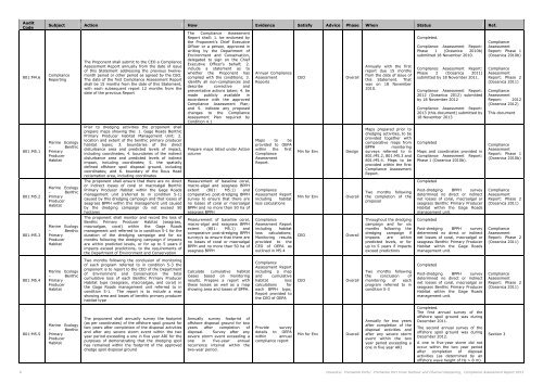
AuditCode801:M4.6801:M5.1801:M5.2801:M5.3Subject Action How Evidence Satisfy Advice Phase When Status Ref.ComplianceReportingMarine Ecology– BenthicPrimaryProducerHabitatMarine Ecology– BenthicPrimaryProducerHabitatMarine Ecology– BenthicPrimaryProducerHabitatThe Proponent shall submit to the CEO a ComplianceAssessment Report annually from the date of issueof this Statement addressing the previous twelvemonthperiod or other period as agreed by the CEO.The date of the first Compliance Assessment Reportshall be 15 months from the date of this Statement,with each subsequent report 12 months from thedate of the previous ReportPrior to dredging activities the proponent shallprepare maps showing the: 1. Gage Roads BenthicPrimary Producer Habitat Management Unit; 2.location <strong>and</strong> extent of the benthic primary producerhabitat types; 3. boundaries of the directdisturbance area <strong>and</strong> predicted levels of impact,including coordinates; 4. boundaries of the indirectdisturbance area <strong>and</strong> predicted levels of indirectimpact, including coordinates; 5. the spatiallydefined offshore spoil disposal ground, includingcoordinates; <strong>and</strong> 6. boundary of the Rous Headreclamation area, including coordinatesThe proponent shall ensure that there are no director indirect losses of coral or macroalgal BenthicPrimary Producer Habitat within the Gage Roadsmanagement unit (referred to in condition 5-1)caused by this dredging campaign <strong>and</strong> that losses ofseagrass BPPH within this management unit causedby the dredging campaign do not exceed 50hectaresThe proponent shall monitor <strong>and</strong> record the loss ofBenthic Primary Producer Habitat (seagrass,macroalgae, coral) within the Gage Roadsmanagement unit referred to in condition 5-1 for theduration of the dredging campaign <strong>and</strong> for sixmonths following the dredging campaign if impactsare within predicted levels, or for up to 5 years ifimpacts exceed predictions, to the requirements ofthe Department of Environment <strong>and</strong> ConservationThe Compliance AssessmentReport shall: 1. be endorsed bythe Proponent’s Chief ExecutiveOfficer or a person, approved inwriting by the Department ofEnvironment <strong>and</strong> Conservation,delegated to sign on the ChiefExecutive Officer’s behalf; 2.include a statement as towhether the Proponent hascomplied with the conditions; 3.identify all non-compliances <strong>and</strong>describe corrective <strong>and</strong>preventative actions taken; 4. bemade publicly available inaccordance with the approvedCompliance Assessment Plan;<strong>and</strong> 5. indicate any proposedchanges to the ComplianceAssessment Plan required byCondition 4.1Prepare maps listed under ActioncolumnMeasurement of baseline coral,macro-algal <strong>and</strong> seagrass BPPHextent (801: M5.1) <strong>and</strong>comparative post-dredging BPPHsurvey to ensure that there areno losses of coral or macroalgalBPPH <strong>and</strong> no more than 50 ha ofseagrass BPPHMeasurement of baseline coral,macro-algal <strong>and</strong> seagrass BPPHextent (801: M5.1) <strong>and</strong>comparative post-dredging BPPHsurvey/s to ensure that there areno losses of coral or macroalgalBPPH <strong>and</strong> no more than 50 ha ofseagrass BPPHAnnual ComplianceAssessmentReportsMaps to beprovided to OEPAwithin the firstComplianceAssessmentReport.ComplianceAssessment Reportincluding habitatloss calculationsComplianceAssessment Reportincluding habitatloss calculations;Monitoring resultsprovided to theCEO of OEPA asoutlined in M5.4CEOMin for EnvMin for EnvCEOOverallDesignOverallOverallAnnually with the firstreport due 15 monthsfrom the date of issue ofthis Statement. Thatwas on 18 November2010.Maps prepared prior todredging activities, to beprovided together withcomparative maps fromBPPH monitoringsurveys referred to in801:M5.2, 801:M5.3 <strong>and</strong>801:M5.4. Maps to beprovided within the firstCompliance AssessmentReport.Two months followingthe completion of theproposalThroughout the dredgingcampaign <strong>and</strong> for sixmonths following thedredging campaign ifimpacts are withinpredicted levels, or forup to 5 years if impactsexceed predictionsCompleted.Compliance Assessment Report:Phase 1 (Oceanica 2010b)submitted 18 November 2010.Compliance Assessment Report:Phase 2 (Oceanica 2011)submitted by 18 November 2011.Compliance Assessment Report:2012 (Oceanica 2012) submittedby 18 November 2012Compliance Assessment Report:2013 (this document) submitted by18 November 2013CompletedMaps <strong>and</strong> coordinates provided inCompliance Assessment Report:Phase 1 (Oceanica 2010b).CompletedPost-dredging BPPH surveydetermined no direct or indirectnet losses of coral, macroalgal orseagrass Benthic Primary ProducerHabitat within the Gage Roadsmanagement unit.CompletedPost-dredging BPPH surveydetermined no direct or indirectnet losses of coral, macroalgal orseagrass Benthic Primary ProducerHabitat within the Gage Roadsmanagement unit.ComplianceAssessmentReport: Phase 1(Oceanica 2010b)ComplianceAssessmentReport: Phase 2(Oceanica 2011)ComplianceAssessmentReport: 2012(Oceanica 2012)This documentComplianceAssessmentReport: Phase 1(Oceanica 2010b)ComplianceAssessmentReport: Phase 2(Oceanica 2011)ComplianceAssessmentReport: Phase 2(Oceanica 2011)801:M5.4Marine Ecology– BenthicPrimaryProducerHabitatTwo months following the conclusion of monitoringof each program referred to in condition 5-3 theproponent is to report to the CEO of the Departmentof Environment <strong>and</strong> Conservation the totalcumulative loss of each Benthic Primary ProducerHabitat type (seagrass, macroalgae, <strong>and</strong> coral) inthe Gage Roads management unit referred to incondition 5-1. The report is to include a mapshowing area <strong>and</strong> losses of benthic primary producerhabitat typeCalculate cumulative habitatlosses based on monitoringresults. Prepare a report withthese losses as well as a mapshowing area <strong>and</strong> losses of BPPH.ComplianceAssessment Reportincluding a map<strong>and</strong> cumulativehabitat losscalculations foreach BPPH type;Report provided tothe CEO of OEPACEOOverallTwo months followingthe conclusion ofmonitoring of eachprogram referred to incondition 5-3CompletedPost-dredging BPPH surveydetermined no direct or indirectnet losses of coral, macroalgal orseagrass Benthic Primary ProducerHabitat within the Gage Roadsmanagement unit.ComplianceAssessmentReport: Phase 2(Oceanica 2011)801:M5.5Marine Ecology– BenthicPrimaryProducerHabitatThe proponent shall annually survey the footprint(as per coordinates) of the offshore spoil ground fortwo years after completion of the disposal activities<strong>and</strong> after any severe storm event within the twoyear period exceeding a one in five year ARI for thepurposes of demonstrating that the dredging spoilhas remained within the footprint of the approveddredge spoil disposal groundAnnually survey footprint ofoffshore disposal ground for twoyears after completion ofdisposal. Survey after anysevere storm event exceeding aone in five-year annualrecurrence interval within thetwo-year period.Provide surveydetails to OEPAwithin annualcompliance reportMin for EnvOverallAnnually for two yearsafter completion of thedisposal activities <strong>and</strong>after any severe stormevent within the twoyear period exceeding aone in five year ARICompleted.The first annual survey of theoffshore spoil ground was duringDecember 2011.The second annual survey of theoffshore spoil ground was duringDecember 2012.A one in five-year storm did notoccur within the two year periodafter completion of disposalactivities (as determined by anoffshore wave height of Hs > 8 m).Section 36 Oceanica: <strong>Fremantle</strong> <strong>Port</strong>s: <strong>Fremantle</strong> <strong>Port</strong> <strong>Inner</strong> <strong>Harbour</strong> <strong>and</strong> <strong>Channel</strong> Deepening, Compliance Assessment Report 2013


