Forest Management Plan - Sabah Forestry Department
Forest Management Plan - Sabah Forestry Department
Forest Management Plan - Sabah Forestry Department

Create successful ePaper yourself
Turn your PDF publications into a flip-book with our unique Google optimized e-Paper software.
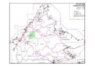
5.0: SOCIO-ECONOMIC ENVIRONMENT5.1 Survey MethodologyThere is no village located within FMU 17A. Therefore, the socio-economic assessmentbased on social baseline survey methodology was conducted in all villages located at thevicinity of FMU 17A (see Table 5.1 and Figure 5.1). The survey was conducted by GFS (M)Sdn Bhd (an appointed consultant) with the help of the SFD field staff from 1 st to 4 thJuly, 2008 in 6 villages. The results of the survey were prepared by GFS (M) Sdn Bhdand reported in their report “Evaluation of High Conservation Value <strong>Forest</strong>s FMU 17ATangkulap & Pinangah <strong>Forest</strong> Reserves”.The study employed both the qualitative and quantitative approaches. In the qualitativeapproach, information on observations of the local people was gathered by theconsultant. This was to ensure that the views and experiences of the local people werecaptured accurately. On the other hand, the quantitative approach would allow theconsultant to collect the data by assigning numerical values to concepts under study andanalyse it objectively. The questionnaire developed is based on the “Social ImpactAssessment” form developed by the consultant.Besides individual interviews, focus group interviews were also carried out to identifyand assess community needs and resources. The group interviews took place in therespective village main hall (dewan) where all members of the community of the villagewere invited to attend. The survey was conducted through a general meeting, as well as,by visiting individual households based on Procedure #2 – (Appendix C). The collectionof information and sampling of viewpoints were taken from men and women within thevillage besides the village leaders.Table 5.1: List and location of the villages surveyed adjacent to FMU 17A# Villages GPS location1 Kg. Kenang-Kenangan (Kg. Tamoi) N 05° 18’ 09.4”, E 117° 15’ 08.5”2 Kg. Karamuak Dalam N 05° 17’ 26.2”, E 117° 12’ 40.4”3 Kg Karamuak Luar N 05° 17’ 00.6”, E 117° 12’ 32.9”4 Kg Entilibon Asal Tongod N 05° 31’ 38.5”, E 117° 02’ 37.3”5 Kg. Entilibon Simpang N 05° 31’ 11.2”, E 117° 02’ 33.6”6 Kg. Tenaga Baru & Mapad N 05° 17’ 09.0”, E 117° 11’ 17.0”42