Central Welland River Watershed Plan - Niagara Peninsula ...
Central Welland River Watershed Plan - Niagara Peninsula ...
Central Welland River Watershed Plan - Niagara Peninsula ...
- No tags were found...
You also want an ePaper? Increase the reach of your titles
YUMPU automatically turns print PDFs into web optimized ePapers that Google loves.
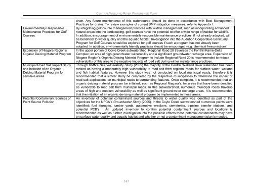
CENTRAL WELLAND RIVER WATERSHED PLANEnvironmentally ResponsibleMaintenance Practices for GolfCoursesExpansion of <strong>Niagara</strong> Region‟sOrganic Deicing Material ProgramMunicipal Road Salt Impact Studyand Initiation of an OrganicDeicing Material Program forsensitive areasPotential Contaminant Sources ofPoint Source Pollutiondrain. Any future maintenance of this watercourse should be done in accordance with Best ManagementPractices for drains. To review examples of current BMP mitigation measures, refer to Appendix I.By integrating golf course management practices with wildlife management, such as incorporating enhancednatural areas into the landscaping, golf courses have the potential to offer a wide range of habitat for wildlife.In addition, encouragement of environmentally responsible maintenance practices, if not already adopted, willbe beneficial to water quality and the aquatic habitat. Investigation into the Audubon Cooperative SanctuaryProgram for Golf Courses should be explored for golf courses if such a program has not already beenadopted. In addition, environmentally friendly practices should be encouraged (e.g. chemical free practices).In the upper portion of Coyle Creek subwatershed, Regional Road 20 traverses the Fonthill Kame-DeltaComplex; an area of high groundwater vulnerability and a significant groundwater recharge area. Expansion of<strong>Niagara</strong> Region‟s Organic Deicing Material Program to include Regional Road 20 is recommended to reducevulnerability of this area to the negative impacts of road salt during winter maintenance practices.Through RMN‟s Salt Vulnerability Study (2005) the majority of the <strong>Central</strong> <strong>Welland</strong> <strong>River</strong> watershed has beenranked as having a moderately high vulnerability to road salt from regional roads for surface water, wetlandand fish habitat features. However this study was not conducted on local municipal roads; therefore it isrecommended that a similar study be completed by the respective municipalities to determine the impact ofroad salt applications on municipal roads to surrounding features. Once complete, it is recommended that anorganic deicing material program be initiated, such as Regional <strong>Niagara</strong>‟s, for areas that have been identifiedas vulnerable to road salt from municipal roads. In this subwatershed, numerous municipal roads traverseareas of high and medium vulnerability as well as significant groundwater recharge areas. It is recommendedthat the initiation of an organic de-icing material program be implemented in these areas.An inventory of potential contaminant sources and threats to water quality was identified as part of theobjectives for the NPCA‟s Groundwater Study (2005). In the Coyle Creek subwatershed numerous points wereidentified; fuel storages, lumber yards, automotive wreckers, cemeteries, pipeline transfer stations, andpotential PCB‟s. An updated inventory to confirm potential contaminant sources and locations isrecommended as well as further investigation into the possible effects these potential contaminants may haveon surface water quality and aquatic habitat and whether or not a contaminant management plan is needed.147


