

Central Welland River Watershed Plan - Niagara Peninsula ...
Central Welland River Watershed Plan - Niagara Peninsula ...
Central Welland River Watershed Plan - Niagara Peninsula ...
- No tags were found...

Create successful ePaper yourself
Turn your PDF publications into a flip-book with our unique Google optimized e-Paper software.
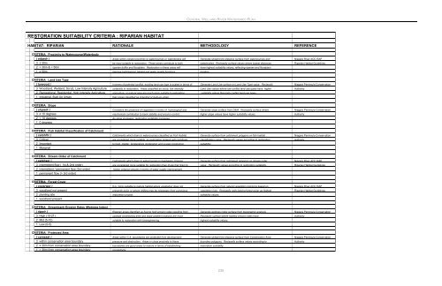
CENTRAL WELLAND RIVER WATERSHED PLANRESTORATION SUITABILITY CRITERIA : RIPARIAN HABITATHABITAT: RIPARIAN RATIONALE METHODOLOGY REFERENCECRITERIA: Proximity to Watercourse/Waterbody( edgedr ) Areas within closest proximity to watercourses or waterbodies will Generate straight line distance surface from watercourses and <strong>Niagara</strong> <strong>River</strong> AOC RAP3 ≤ 30m be most suitable to restoration. These areas contribute to both waterbodies. Reclassify surface values where lowest distances Riparian Habitat Guidelines2 > 30m & < 50m riparian buffer and floodplain. Restoration in these areas will have highest suitability values, reflecting riparian and floodplain1 ≥ 50m improve hydrological, habitat and water quality functions. location.CRITERIA: Land Use Type( lurwood ) In terms of potential conflict, existing land use type is scaled in terms of Generate Land Use surface on Land Use Type value. Reclassify <strong>Niagara</strong> <strong>Peninsula</strong> Conservation3 Woodland, Wetland, Scrub, Low Intensity Agriculture suitability to restoration. Areas classified as scrub, low intensity Land Use values where low conflict land use types have higher Authority2 Recreational, Residential, High Intensity Agriculture agriculture, or natural area are much more suitable to restoration suitability values than high conflict land use types.1 Industrial, Built Up Urban than areas classified as industrial or built-up urban.CRITERIA: Slope( slopedr ) Considers the presence of vegetation in terms of hydrological and Generate slope surface from DEM. Reclassify surface where <strong>Niagara</strong> <strong>Peninsula</strong> Conservation3 ≥ 10 degrees mechanical contribution to bank stability and erosion control. higher slope values have higher suitability values. Authority2 < 10 degrees As slope increases, restoration suitability increases.1 0 degreesCRITERIA: Fish Habitat Classification of Catchment( catchfhr ) Catchments which drain to watercourses classified as Fish Habitat Generate surface from catchment polygons on fish habitat <strong>Niagara</strong> <strong>Peninsula</strong> Conservation3 Critical are considered more suitable, as restoration projects will contribute classification value. Reclassify values according to restoration Authority2 Important to food, shelter, temperature moderation and oxygen production. suitability.1 MarginalCRITERIA: Stream Order of Catchment( catchsor ) Catchments which drain to watercourses in headwater streams Generate surface from catchment polygons on stream order <strong>Niagara</strong> <strong>River</strong> AOC RAP3 intermittent flow ( 1st & 2nd order) are considered more suitable for restoration than those that drain to value. Reclassify values according to restoration suitability. Riparian Habitat Guidelines2 intermittent / permanent flow (3rd order) higher ordered streams in terms of water quality improvement.1 permanent flow (> 3rd order)CRITERIA: Forest Cover( coverwor ) It is more suitable to restore habitat where vegetation does not Generate surface from natural vegetation polygons based on <strong>Niagara</strong> <strong>River</strong> AOC RAP3 woodland not present presently exist, or where infilling may be necessary from a previous vegetation type. Reclassify cells lacking forest cover as highest Riparian Habitat Guidelines2 planting site restoration project. suitability values.1 woodland presentCRITERIA: Streambank Erosion Rates (Wetness Index)( ripwir ) Riparian areas identified as having high erosion rates resulting from Generate wetness index surface from topographic analysis. <strong>Niagara</strong> <strong>Peninsula</strong> Conservation3 High (10-21) upslope contributing area and slope gradient analysis are most Reclassify surface where highest erosion rates have Authority2 Mid (5-10) suitable to restoration with bioengineering. highest suitability values.1 Low (0-5)CRITERIA: Protected Area( careasdr ) Areas within C.A. boundaries are protected from development Generate straight line distance surface from Conservation Area <strong>Niagara</strong> <strong>Peninsula</strong> Conservation3 within conservation area boundary pressure and destruction. Areas in close proximity to these boundary polygons. Reclassify surface values according to Authority2 ≤ 30m from conservation area boundary boundaries are good areas to restore in terms of establishing restoration suitability.1 > 30m from conservation area boundary connectivity.235


