

Central Welland River Watershed Plan - Niagara Peninsula ...
Central Welland River Watershed Plan - Niagara Peninsula ...
Central Welland River Watershed Plan - Niagara Peninsula ...
- No tags were found...

You also want an ePaper? Increase the reach of your titles
YUMPU automatically turns print PDFs into web optimized ePapers that Google loves.
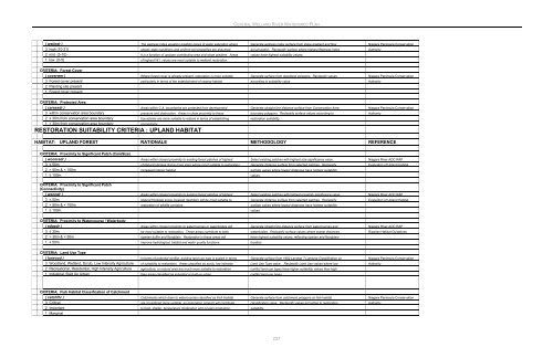
CENTRAL WELLAND RIVER WATERSHED PLAN( wetindr ) The wetness index equation predicts zones of water saturation where Generate wetness index surface from slope gradient and flow <strong>Niagara</strong> <strong>Peninsula</strong> Conservation3 high (10-21) steady-state conditions and uniform soil properties are assumed. accumulation. Reclassify surface where highest Wetness Index Authority2 mid (5-10) It is a function of upslope contributing area and slope gradient. Areas values have highest suitability values.1 low (0-5) of highest W.I. values are most suitable to wetland restoration.CRITERIA: Forest Cover( coverwer ) Where forest cover is already present, restoration is more suitable Generate surface from woodland polygons. Reclassify values <strong>Niagara</strong> <strong>Peninsula</strong> Conservation3 Forest cover present particularly in terms of the establishment of swamp habitat. according to suitability value. Authority2 <strong>Plan</strong>ting site present1 Forest cover presentCRITERIA: Protected Area( careasdr ) Areas within C.A. boundaries are protected from development Generate straight line distance surface from Conservation Area <strong>Niagara</strong> <strong>Peninsula</strong> Conservation3 within conservation area boundary pressure and destruction. Areas in close proximity to these boundary polygons. Reclassify surface values according to Authority2 ≤ 30m from conservation area boundary boundaries are more suitable to restore in terms of establishing restoration suitability.1 > 30m from conservation area boundary connectivity.RESTORATION SUITABILITY CRITERIA : UPLAND HABITATHABITAT: UPLAND FOREST RATIONALE METHODOLOGY REFERENCECRITERIA: Proximity to Significant Patch (CoreSize)( wocoredr ) Areas within closest proximity to existing forest patches of highest Select existing patches with highest size significance value. <strong>Niagara</strong> <strong>River</strong> AOC RAP3 ≤ 50m of Natural Heriage Score (core size) will be most suitable to restoration Generate distance surface from selected patches. Reclassify Evaluation of Upland Habitat2 > 50m & < 100m increased interior habitat. surface values where lowest distances have highest suitability1 ≥ 100m values.CRITERIA: Proximity to Significant Patch(Connectivity)( wonndr ) Areas within closest proximity to existing forest patches of highest Select existing patches with highest proximity significance value. <strong>Niagara</strong> <strong>River</strong> AOC RAP3 ≤ 50m Natural Heritage score (nearest neighbor) will be most suitable to Generate distance surface from selected patches. Reclassify Evaluation of Upland Habitat2 > 50m & < 100m restoration of wildlife corridors. surface values where lowest distances have highest suitability1 ≥ 100m values.CRITERIA: Proximity to Watercourse / Waterbody( edgedr ) Areas within closest proximity to watercourses or waterbodies will Generate straight line distance surface from watercourses and <strong>Niagara</strong> <strong>River</strong> AOC RAP3 ≤ 30m be most suitable to restoration. These areas contribute to both waterbodies. Reclassify surface values where lowest distances Riparian Habitat Guidelines2 > 30m & < 50m riparian buffer and floodplain. Restoration in these areas will have highest suitability values, reflecting riparian and floodplain1 ≥ 50m improve hydrological, habitat and water quality functions. location.CRITERIA: Land Use Type( lurwood ) In terms of potential conflict, existing land use type is scaled in terms Generate surface from 1992 Landsat 7 Landuse Classification on <strong>Niagara</strong> <strong>Peninsula</strong> Conservation3 Woodland, Wetland, Scrub, Low Intensity Agriculture of suitability to restoration. Areas classified as scrub, low intensity Land Use Type value . Reclassify Land Use values where low Authority2 Recreational, Residential, High Intensity Agriculture agriculture, or natural area are much more suitable to restoration conflict land use types have higher suitability values than high1 Industrial, Built Up Urban than areas classified as industrial or built-up urban. conflict land use types.CRITERIA: Fish Habitat Classification of Catchment( catchfhr ) Catchments which drain to watercourses classified as Fish Habitat Generate surface from catchment polygons on fish habitat <strong>Niagara</strong> <strong>Peninsula</strong> Conservation3 Critical are considered more suitable, as restoration projects will contribute classification value. Reclassify values according to restoration Authority2 Important to food, shelter, temperature moderation and oxygen production. suitability.1 Marginal237


