
You also want an ePaper? Increase the reach of your titles
YUMPU automatically turns print PDFs into web optimized ePapers that Google loves.
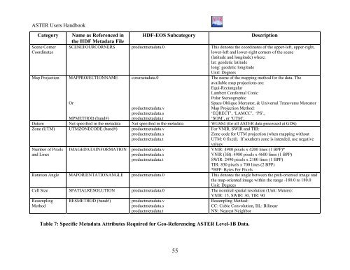
<strong>ASTER</strong> Users HandbookCategoryScene CornerCoordinatesMap ProjectionName as Referenced inthe HDF Metadata FileHDF-EOS SubcategoryDescriptionSCENEFOURCORNERS productmetadata.0 This denotes the coordinates of the upper-left, upper-right,lower-left and lower-right corners of the scene(latitude and longitude) where:lat: geodetic latitudelong: geodetic longitudeUnit: DegreesMAPPROJECTIONNAME coremetadata.0The name of the mapping method for the data. Theavailable map projections are:Equi-RectangularLambert Conformal ConicPolar StereographicOrSpace Oblique Mercator, & Universal Transverse MercatorMap Projection Method:‘EQRECT’, ‘LAMCC’, ‘PS’,‘SOM’, or ‘UTM’,productmetadata.vproductmetadata.sMPMETHOD (band#)productmetadata.tDatum Not specified in the metadata Not specified in the metadata WGS84 (for all <strong>ASTER</strong> data processed at GDS)Zone (UTM) UTMZONECODE (band#) productmetadata.vproductmetadata.sproductmetadata.tNumber of Pixelsand LinesIMAGEDATAINFORMATIONproductmetadata.vproductmetadata.sproductmetadata.tFor VNIR, SWIR and TIR:Zone code for UTM projection (when mapping withoutUTM: 0 fixed). If southern zone is intended, use negativevaluesVNIR: 4980 pixels x 4200 lines (1 BPP)*VNIR (3B): 4980 pixels x 4600 lines (1 BPP)SWIR: 2490 pixels x 2100 lines (1 BPP)TIR: 830 pixels x 700 lines (2 BPP)*BPP: Bytes Per PixelsRotation Angle MAPORIENTATIONANGLE productmetadata.0 This denotes the angle between the path-oriented image andthe map-oriented image within the range -180.0 to 180.0Unit: DegreesCell Size SPATIALRESOLUTION productmetadata.0 The nominal spatial resolution (Unit: Meters):VNIR: 15, SWIR: 30, TIR: 90ResamplingMethodRESMETHOD (band#)productmetadata.vproductmetadata.sproductmetadata.tResampling Method:CC: Cubic Convolution, BL: BilinearNN: Nearest NeighborTable 7: Specific Metadata Attributes Required for Geo-Referencing <strong>ASTER</strong> Level-1B Data.55