
Create successful ePaper yourself
Turn your PDF publications into a flip-book with our unique Google optimized e-Paper software.
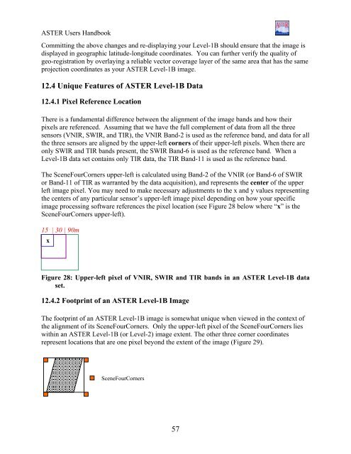
<strong>ASTER</strong> Users HandbookCommitting the above changes and re-displaying your Level-1B should ensure that the image isdisplayed in geographic latitude-longitude coordinates. You can further verify the quality ofgeo-registration by overlaying a reliable vector coverage layer of the same area that has the sameprojection coordinates as your <strong>ASTER</strong> Level-1B image.12.4 Unique Features of <strong>ASTER</strong> Level-1B Data12.4.1 Pixel Reference LocationThere is a fundamental difference between the alignment of the image bands and how theirpixels are referenced. Assuming that we have the full complement of data from all the threesensors (VNIR, SWIR, and TIR), the VNIR Band-2 is used as the reference band, and data for allthe three sensors are aligned by the upper-left corners of their upper-left pixels. When there areonly SWIR and TIR bands present, the SWIR Band-6 is used as the reference band. When aLevel-1B data set contains only TIR data, the TIR Band-11 is used as the reference band.The SceneFourCorners upper-left is calculated using Band-2 of the VNIR (or Band-6 of SWIRor Band-11 of TIR as warranted by the data acquisition), and represents the center of the upperleft image pixel. You may need to make necessary adjustments to the x and y values representingthe centers of any particular sensor’s upper-left image pixel depending on how your specificimage processing software references the pixel location (see Figure 28 below where “x” is theSceneFourCorners upper-left).15 | 30 | 90mxFigure 28: Upper-left pixel of VNIR, SWIR and TIR bands in an <strong>ASTER</strong> Level-1B dataset.12.4.2 Footprint of an <strong>ASTER</strong> Level-1B ImageThe footprint of an <strong>ASTER</strong> Level-1B image is somewhat unique when viewed in the context ofthe alignment of its SceneFourCorners. Only the upper-left pixel of the SceneFourCorners lieswithin an <strong>ASTER</strong> Level-1B (or Level-2) image extent. The other three corner coordinatesrepresent locations that are one pixel beyond the extent of the image (Figure 29).SceneFourCorners57