
Create successful ePaper yourself
Turn your PDF publications into a flip-book with our unique Google optimized e-Paper software.
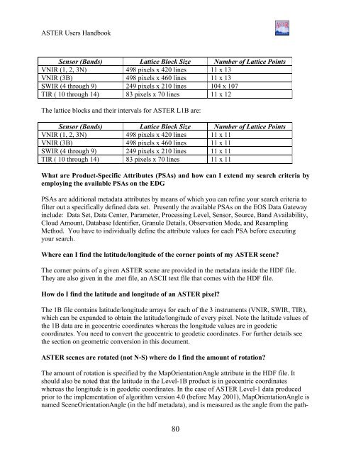
<strong>ASTER</strong> Users HandbookSensor (Bands) Lattice Block Size Number of Lattice PointsVNIR (1, 2, 3N) 498 pixels x 420 lines 11 x 13VNIR (3B) 498 pixels x 460 lines 11 x 13SWIR (4 through 9) 249 pixels x 210 lines 104 x 107TIR ( 10 through 14) 83 pixels x 70 lines 11 x 12The lattice blocks and their intervals for <strong>ASTER</strong> L1B are:Sensor (Bands) Lattice Block Size Number of Lattice PointsVNIR (1, 2, 3N) 498 pixels x 420 lines 11 x 11VNIR (3B) 498 pixels x 460 lines 11 x 11SWIR (4 through 9) 249 pixels x 210 lines 11 x 11TIR ( 10 through 14) 83 pixels x 70 lines 11 x 11What are Product-Specific Attributes (PSAs) and how can I extend my search criteria byemploying the available PSAs on the EDGPSAs are additional metadata attributes by means of which you can refine your search criteria tofilter out a specifically defined data set. Presently the available PSAs on the EOS Data Gatewayinclude: Data Set, Data Center, Parameter, Processing Level, Sensor, Source, Band Availability,Cloud Amount, Database Identifier, Granule Details, Observation Mode, and ResamplingMethod. You have to individually define the attribute values for each PSA before executingyour search.Where can I find the latitude/longitude of the corner points of my <strong>ASTER</strong> scene?The corner points of a given <strong>ASTER</strong> scene are provided in the metadata inside the HDF file.They are also given in the .met file, an ASCII text file that comes with the HDF file.How do I find the latitude and longitude of an <strong>ASTER</strong> pixel?The 1B file contains latitude/longitude arrays for each of the 3 instruments (VNIR, SWIR, TIR),which can be expanded to obtain the latitude/longitude of every pixel. Note the latitude values ofthe 1B data are in geocentric coordinates whereas the longitude values are in geodeticcoordinates. You need to convert the geocentric to geodetic coordinates. For further details seethe section on geometric conversion in this document.<strong>ASTER</strong> scenes are rotated (not N-S) where do I find the amount of rotation?The amount of rotation is specified by the MapOrientationAngle attribute in the HDF file. Itshould also be noted that the latitude in the Level-1B product is in geocentric coordinateswhereas the longitude is in geodetic coordinates. In the case of <strong>ASTER</strong> Level-1 data producedprior to the implementation of algorithm version 4.0 (before May 2001), MapOrientationAngle isnamed SceneOrientationAngle (in the hdf metadata), and is measured as the angle from the path-80