Parramatta - Burwood - Transport for NSW
Parramatta - Burwood - Transport for NSW
Parramatta - Burwood - Transport for NSW

You also want an ePaper? Increase the reach of your titles
YUMPU automatically turns print PDFs into web optimized ePapers that Google loves.
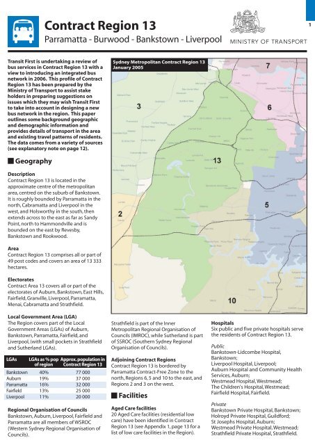
Contract Region 13<strong>Parramatta</strong> - <strong>Burwood</strong> - Bankstown - Liverpool1Transit First is undertaking a review ofbus services in Contract Region 13 with aview to introducing an integrated busnetwork in 2006. This profile of ContractRegion 13 has been prepared by theMinistry of <strong>Transport</strong> to assist stakeholders in preparing suggestions onissues which they may wish Transit Firstto take into account in designing a newbus network in the region. This paperoutlines some background geographicand demographic in<strong>for</strong>mation andprovides details of transport in the areaand existing travel patterns of residents.The data comes from a variety of sources(see explanatory note on page 12).Sydney Metropolitan Contract Region 13January 2005GeographyDescriptionContract Region 13 is located in theapproximate centre of the metropolitanarea, centred on the suburb of Bankstown.It is roughly bounded by <strong>Parramatta</strong> in thenorth, Cabramatta and Liverpool in thewest, and Holsworthy in the south, thenextends across to the east as far as SandyPoint, north to Hammondville and isbounded on the east by Revesby,Bankstown and Rookwood.AreaContract Region 13 comprises all or part of49 post codes and covers an area of 13 333hectares.ElectoratesContract Area 13 covers all or part of theelectorates of Auburn, Bankstown, East Hills,Fairfield, Granville, Liverpool, <strong>Parramatta</strong>,Menai, Cabramatta and Strathfield.Local Government Area (LGA)The Region covers part of the LocalGovernment Areas (LGAs) of Auburn,Bankstown, <strong>Parramatta</strong>, Fairfield, andLiverpool, (with small pockets in Strathfieldand Sutherland LGAs).LGAsLGAs as % popof regionApprox. population inContract Region 13Bankstown 40% 77 000Auburn 19% 37 000<strong>Parramatta</strong> 16% 32 000Fairfield 13% 25 000Liverpool 11% 20 000Regional Organisation of CouncilsBankstown, Auburn, Liverpool, Fairfield and<strong>Parramatta</strong> are all members of WSROC(Western Sydney Regional Organisation ofCouncils).Strathfield is part of the InnerMetropolitan Regional Organisation ofCouncils (IMROC), while Sutherland is partof SSROC (Southern Sydney RegionalOrganisation of Councils).Adjoining Contract RegionsContract Region 13 is bordered by<strong>Parramatta</strong> Contract-Free Zone to thenorth, Regions 6, 5 and 10 to the east, andRegions 2 and 3 on the west.FacilitiesAged Care facilities20 Aged Care facilities (residential lowcare) have been identified in ContractRegion 13 (see Appendix 1, page 13 <strong>for</strong> alist of low care facilities in the Region).HospitalsSix public and five private hospitals servethe residents of Contract Region 13.PublicBankstown-Lidcombe Hospital,Bankstown;Liverpool Hospital, Liverpool;Auburn Hospital and Community Health Services, Auburn;Westmead Hospital, Westmead;The Children's Hospital, Westmead;Fairfield Hospital, Fairfield.PrivateBankstown Private Hospital, Bankstown;Holroyd Private Hospital, Guild<strong>for</strong>d;St Josephs Hospital, Auburn;Westmead Private Hospital, Westmead;Strathfield Private Hospital, Strathfield.
2 Educational Institutions (Universities, TAFE)The following educational institutions can be easily accessed byresidents in the Region:UniversityUniversity of Western Sydney (Bankstown Campus, Milperra) andThe University of Sydney (Cumberland Campus, Lidcombe).TAFESouthern Sydney Institute of TAFE (Bankstown Campus)Southern Sydney Institute of TAFE (Bankstown Campus Annex,Chullora)Southern Sydney Institute of TAFE (Lidcombe Campus)Southern Sydney Institute of TAFE (Padstow Campus)South Western Sydney Institute of TAFE (Granville Campus)South Western Sydney Institute of TAFE (Liverpool Campus) Other institutionsBankstown Community College, BankstownMartin College, <strong>Parramatta</strong>Southern Cross College, Chester HillEducational Institutions (schools)In the region there are:39 high schools 64 primary schools2 infants school 9 K-12 schools and4 special schools (see Appendix 2).Other places of interestAuburn Botanic Gardens and Japanese GardensBankstown AirportBankstown City PacewayBankstown Homemaker CityBankstown City Sports ComplexBass Hill Tourist (Caravan) ParkChipping Norton LakeChullora Railway WorkshopsDunc Gray Velodrome/Crest Park complex/BMX track, Georges HallMirambeena Regional Park, LansdowneMilperra Industrial AreaOmar Mosque, AuburnRookwood CemeteryVillawood Immigration Detention CentreWarwick Farm RacecourseYennora Distribution (industrial) ParkCentresA regional centre is generally located at a major rail station, has adepartment store(s), discount department store, a large range ofspecialty shops, cinemas and restaurants, governmentadministration and office employment.District centres generally provide a large supermarket and alimited range of specialty shops. Some district centres have adiscount department store.<strong>Burwood</strong> has been included as a Regional Centre even though itis outside the boundary of Region 13, as it (and the <strong>Parramatta</strong>Road corridor) is expected to increasingly impact on trip makingin the Region.Regional CentresLiverpool Bankstown <strong>Burwood</strong> <strong>Parramatta</strong>District CentresAuburn Berala Bass Hill CabramattaChester Hill Chullora Fairfield GranvilleGuild<strong>for</strong>d Lidcombe Merrylands MoorebankRegents Park Strathfield Wattle GroveSpecialised CentresBankstown AirportData collected by the <strong>Transport</strong> Population and Data Centre(TPDC) <strong>for</strong> the Household Travel Survey (HTS) on all travel on anaverage day in 2002, is mapped to illustrate the catchment area<strong>for</strong> travel to centres (see following pages).BankstownThe major catchment <strong>for</strong> trips to Bankstown (from HTS data)extends from Villawood, Lansdowne and Georges Hall, down toPicnic Point and Padstow Heights, and across to Wiley Park. Alower number of trips are generated from Liverpool, ChippingNorton, Moorebank, Milperra and Revesby, with pockets fromLidcombe and Ashcroft. As with other major centres, there arealso trips originating from far-flung suburbs such as BlacktownSouth and Campbelltown.<strong>Burwood</strong>The highest numbers of trips to <strong>Burwood</strong> originate from<strong>Burwood</strong> itself, then from suburbs close to <strong>Burwood</strong>, such asCroydon Park and the southern half of Concord. Far flung originsinclude Taren Point and Kensington.LiverpoolTrips focussed on Liverpool originate in high numbers from westof the railway line close to Liverpool, and from Lurnea and Casulato the south. Medium-high levels of trip making come fromWarwick Farm, Chipping Norton, Moorebank and Wattle Grove,and Ashcroft and Hinchinbrook.<strong>Parramatta</strong>Trips ending in <strong>Parramatta</strong> start from <strong>Parramatta</strong>, then fromsurrounding suburbs including North <strong>Parramatta</strong> and WinstonHills. Other significant origins include Fairfield West and KingsLangley. Lower levels of trips come from other dispersed suburbssuch as Mulgoa and Glenfield.Suburbs, % in Region, LGA and ElectorateSuburbBeralaRegents ParkBirrongChulloraPotts HillSeftonYagoonaBankstown AirportGeorges HallBass Hill% in ContactRegion100100100100100100100100100100Chester Hill 100Lansdowne 100Villawood 100Carramar100Fairfield East100Lansvale100Chipping Norton 100Hammondville 100Wattle Grove100South Granville 100Sandy Point100Old Guild<strong>for</strong>d>90Moorebank>90Pleasure Point>90Voyager Point>90Granville>90Rookwood>90Condell Park>90Auburn>90Milperra>85Harris Park80Warwick Farm>60Canley Vale>55Lidcombe>50Greenacre>50Bankstown>45Guild<strong>for</strong>d >45Holsworthy45Clyde >35Cabramatta>30Fairfield>25Yennora>25Revesby>15Strathfield South >15Merrylands>15Strathfield>5Holroyd>5<strong>Parramatta</strong>>5LGAAuburnAuburnBankstownBankstownBankstownBankstownBankstownBankstownBankstownBankstownBankstownBankstownBankstownFairfieldFairfieldLiverpoolLiverpoolLiverpoolLiverpool<strong>Parramatta</strong>SutherlandFairfieldLiverpoolLiverpoolLiverpool<strong>Parramatta</strong>AuburnBankstownAuburnBankstown<strong>Parramatta</strong>LiverpoolFairfieldAuburnBankstownBankstown<strong>Parramatta</strong>Liverpool<strong>Parramatta</strong>FairfieldFairfieldFairfieldBankstownStrathfield<strong>Parramatta</strong>Strathfield<strong>Parramatta</strong><strong>Parramatta</strong>ElectorateAuburnAuburnAuburnAuburnAuburnAuburnAuburnEast HillsEast HillsFairfieldFairfieldFairfieldFairfieldFairfieldFairfieldLiverpoolMenaiMenaiMenaiGranvilleMenaiFairfieldMenaiMenaiMenaiGranvilleAuburnEast HillsAuburnEast Hills<strong>Parramatta</strong>LiverpoolFairfieldAuburnBankstownBankstownGranvilleMenai<strong>Parramatta</strong>FairfieldFairfieldFairfieldEast HillsStrathfieldGranvilleStrathfieldGranville<strong>Parramatta</strong>
Origin Zone of Trips to Bankstown CBD3Origin Zone of Trips to <strong>Burwood</strong> CBD
4Origin Zone of Trips to Liverpool CBDOrigin Zone of Trips to <strong>Parramatta</strong> CBD
Shopping Centres5CentreAuburn CentralAuburnShoppingVillageAuburnShoppingArcadeCentroBankstownSouth TerracePlaza,BankstownBass Hill PlazaWestfield<strong>Burwood</strong><strong>Burwood</strong> PlazaCabramattaCommercialCentreChester SquareShoppingCentreChulloraMarketplaceThe Old BakeryShoppingCentre, CondellParkNeeta CityShoppingCentre, FairfieldFairfield ForumFairfield ChaseWestfieldLiverpoolLiverpool PlazaShoppingCentreWestfield<strong>Parramatta</strong>StocklandMerrylandsStrathfieldPlazaWattle GrovePlazaMajorTenantsBig W,WoolworthsColesDJs, Kmart, Target,Woolworths,FranklinsFranklinsTarget,Woolworths,FranklinsMyer, Kmart,Target, Coles,WoolworthsWoolworths, Best& Less, Ron'sDiscount VarietyBing LeeFood <strong>for</strong> Less,Go-LoBig W,WoolworthsFranklinsBig W,Woolworths, Best& LessKmart, Coles,Food <strong>for</strong> LessMedical CentreMyer, Target,Woolworths, ToysR Us, Coles, Best& Less, The RejectShopFranklinsMyer, DJs, Target,Kmart,Woolworths, ToysR Us, Coles,Lincraft, RebelSport, GowingsKmart, Coles,Franklins, Best &Less, Go-LoWoolworthsColesMajorTenantsm 210,7402,188033,5902,20014,46334,4985,3408003,20412,3661,10012,04811,7191,32738,2361,29073,06618,5902,5212,135512214254145723651828461855502021440396745217No ofSpecialtiesSpecialtiesm 25,8302,2872,02432,7771,3304,96622,4975,2271,5942,9764,8591,7346,4405,2172,16821,0194,62842,2126,5923,9271,014TotalRetailm 216,5704,4752,02466,3673,53019,42956,99510,5672,3946,18017,2252,83418,48816,9363,49559,2555,918115,27825,1826,4483,149OtherTenantsVillageTavernFamily DayCareGreaterUnion,Storerooms,Child Care,SK Hand CarWashGymAmusementParlourFitnessCentreMedicare,MPsWorldCinemasGreaterUnion,Storerooms,Galaxy, CarWashStorerooms,Village,MedialCentre,FunctionCentre,FitnessCentre,Good Year,Child CareCentre,GalaxyHoyts,BanksMedicalCentreOtherTenantsm 204650002507,7261,20128809,975754293010,40009,2744380196OfficeTenantsm 2016332913000060000001,1001,0064,54902843,59007,1950TotalCentrem 216,5705,1032,35366,4973,53019,67964,72112,3684,2106,18027,2003,58819,88117,9428,04469,6556,202128,14225,62013,6433,345OpenCarBays001,7552562593020301658001307007651101,2782501,4241,095209191EnclosedCarBays150381,2081601752,17033160700000581,18902,8561002750TotalCar0150382,9631858003,100534602358001307007651682,4672504,2801,195484191Pedestrianpan/a2,300,000250,00014,000,000n/a3,400,00011,400,0004,900,000n/an/a3,600,000n/a5,200,000n/a5,400,00011,800,0005,000,00017,800,0007,743,3105,200,000n/an/a - not availableSource: Property Council of Australia 2004 (Does not include strip shopping precincts.)
6DemographicsPopulation 2001In 2001, the population of Contract Region 13 was approximately193 652 . This is predicted to rise to 218 966 by 2031, reflectingan annual growth rate over the period of 0.4% (below theRegional average of 0.9%).This Region is ranked at number 9 outof the 15 bus contract regions in terms of population size.Region 13encompasses (bypopulation): 45% inthe Bankstown LGA,64% in the AuburnLGA, 22% in the<strong>Parramatta</strong> LGA, 14%in the Fairfield LGAand 13% in theLiverpool LGAPopulationContract Regions Ranked by2001 Population600,000500,000400,000300,000200,000100,00006 4 9 1 310 7 81312 5 2151411Contract RegionPopulation Profile40% of Contract Region 13's population is in the Bankstown LGA,while a further 20% is in the Auburn LGA.The remainder are inthe <strong>Parramatta</strong> LGA, the Fairfield LGA and the Liverpool LGA, withsmall numbers in the Strathfield and Sutherland LGAs.Population changeSome areas in Contract Region 13 have experienced populationchange of 10 per cent or more between the 1996 and 2001Censuses.These areas include immediately north of the watersupply pipeline (in the suburbs of Regents Park, the southernpart of Auburn and South Granville); immediately south of thewater supply pipeline (Potts Hill and that part of Birrong east ofthe Bankstown rail line); south of the Hume Highway (WarwickFarm and Chipping Norton); south of the South WesternMotorway (Moorebank, Wattle Grove and Voyager Point); andBankstown.Population by AgeAgeAge Group % by AgeGroup% Groupedby Age GroupBased on the 2001Census, there are largeAged 0-4 7.9% 7.9%numbers (10 per centor more) of childrenAged 5-9 7.1%aged 0-4 south of theAged 10-14 7.0% 21.3%South WesternAged 15-19 7.2%Motorway (in theAged 20-24 7.3%newer suburbs ofAged 25-29 7.9%Moorebank, WattleAged 30-34 8.1% 55.4% Grove and VoyagerAged 35-39 7.9%Point).Aged 40-44 7.3%Aged 45-49 6.5%Similarly, there areAged 50-54 6.0%concentrations of 18Aged 55-59 4.5% per cent or more ofAged 60-64 3.6%those aged 5-14 yearsAged 65-69 3.1%in Wattle Grove andAged 70-74 3.3%Voyager Point; inAged 75-79 2.6% 15.3% South Granville andAged 80-84 1.6%pockets extendingAged 85-89 0.8%north throughAged 90-94 0.3%Granville; and someAged 95-99 0.1%pockets in Sefton westof the Bankstown railAged 100+ 0.0%line.Total 99.9% 99.9%Those aged 55-64 years (in concentrations of 13 or more percent) are found immediately north of the South Western Freewayin Moorebank, and in Chipping Norton and Lansvale; and in apocket of Warwick Farm immediately north of the HumeHighway.Areas where there are concentrations of 24 per cent or more ofthose aged 65 years or older are in Hammondville, with a pocketimmediately north of the Inner West rail line and west ofWoodville Road at Villawood. Concentrations of between 16 and24 per cent are mainly south of the Inner West rail line inVillawood and Chester Hill, and east of the Hume Highway inWarwick Farm.Languages other then English (LOTE)In the LGAs in ContractLGAPopulationRegion 13, there are largespeaking Englishnumbers of people who"not well/not at all"identify as speakingAuburn7,251English "not well orBankstown 11,086not at all". <strong>Parramatta</strong> 7,999Fairfield 29,954People not fluent in Liverpool 7,473English (in concentrations>20 per cent) are foundclustered along the raillines in suburbs such as Major Languages (LOTE) SpokenCanley Vale, Fairfield,in each LGAFairfield East,Yennora,Old Guild<strong>for</strong>d andLansvale; Regents Park,Berala, Auburn andGranville.Concentrations of thosespeaking LOTE60% of the regionspopulation speak alanguage other thenEnglish (LOTE) at home.LGABankstownAuburn<strong>Parramatta</strong>MajorlanguagesArabicVietnameseChinese languagesGreekChinese languagesArabicVietnameseArabicChinese LanguagesKoreanThe most commonHindilanguages other thenTurkishEnglish are Arabic, ChineseFairfield VietnameseChineseLanguages and Vietnamese.ItalianLiverpool ArabicThere are large numbersItalianof people (>23 per cent)Vietnameseborn in South-East Asia inSpanishCanley Vale, Lansvale andHindiFairfield East, and thatpocket of Birrong betweenthe water pipeline and therail line. People speaking Language Spoken at HomeChinese languages (inLanguage %concentrations >23 percent), are found along the English 40Bankstown rail line in Arabic 15Regents Park and Berala;and in Clyde and Auburnnorth of the Western railChinese LanguagesVietnameseGreekTurkishline. High concentrations Italian 2(24 per cent or more) of Tagalog 1people speaking Arabic Spanish 1High concentrations (20 per cent or more) of those aged 15-24 (including Lebanese) are Macedonian 1years are found in Moorebank south of the South Western found in Granville, South Hindi 1Motorway and in Holsworthy Barracks. Concentrations ofGranville and Auburn, andKorean 1between 16 and 20 per cent are found in Chipping Norton andCroation 1south through Moorebank to the Motorway, Lansdowne, parts ofin Villawood, north of theAll other 17Georges Hall, and areas of Auburn and Granville.rail line. Total 1008722
Average Household SizePeople in occupied private dwellings with a high averagehousehold size (3.2 people or more) are found throughoutContract Region 13, particularly north of the water supplypipeline in the suburbs of Granville, South Granville and Auburn,and south of the Motorway in the newer areas of Moorebank,Wattle Grove and Voyager Point.DisadvantageThe Index of Advantage/Disadvantage is a continuum ofadvantage to disadvantage from the 2001 Census.The indexvalue of an area is constructed from attributes of the populationin that area such as educational attainment, income,employment and occupation.A higher index value indicates that an area has attributes such asa relatively high proportion of people with high incomes or askilled work<strong>for</strong>ce. It also means an area has a low proportion ofpeople with low incomes and relatively few unskilled people inthe work<strong>for</strong>ce. Conversely, a low index value indicates that anarea has a higher proportion of individuals with low incomes,more employees in unskilled occupations, etc. and a lowproportion of people with high incomes or in skilledoccupations.LGAsIndex of RelativeSocio-EconomicAdvantage/Disadvantage 2001Auburn 6Bankstown 8<strong>Parramatta</strong> 9Fairfield 2Liverpool 8DisabilityFigures on disability in the community vary from about 12% ofthis population in receipt of either a Disability or Age pension, tothe general ABS figure of 20%, giving a range of 24-39 000.For example, 1 in 5 residents (19.3%) in Bankstown on Censusnight identified as having a disability of some sort.LGA% in receiptof a DisabilitySupportPensionApprox. ContractRegion 13 nos. inreceipt of aDisability SupportPension% in receiptof an AgePensionApprox ContractRegion 13nos. in receiptof an AgePensionAuburn 3.4% 1 300 7.8% 3 000Bankstown 3.2% 2 500 10.8% 8 500<strong>Parramatta</strong> 3.2% 1 000 8.0% 2 500Fairfield 3.5% 925 8.7% 2 300Liverpool 3.1% 650 6.5% 1 400EmploymentIn 2001, employment in the Region was 94 422, ranking it eighthamong the 15 contract regions in terms of employment. Overthe 2001-2031 timeframe, employment is predicted to drop to85 116.Of Region 13's total employment:45% is in the Bankstown LGA.13% is in the Auburn LGA10% is in the Fairfield LGA16% is in the Liverpool LGA9% is in the <strong>Parramatta</strong> LGA.Employment in CentresSome employment concentrations in Region 13 are shownbelow:CentreTotalEmploymentLiverpool 9256Bankstown 8667<strong>Burwood</strong> 8129<strong>Parramatta</strong> CBD 35844Auburn 3712Bass Hill 462Cabramatta 3570Fairfield 3839Strathfield 3142Estimates of unemployment rates <strong>for</strong> the September quarter2003 <strong>for</strong> the LGAs are: Bankstown, 8.0%; Auburn, 9.4% 2003;Fairfield 9.9%; Liverpool 6.2%, <strong>Parramatta</strong> 4.9%. (Sydney region'sunemployment is estimated at 5.3%).Work<strong>for</strong>ceThe estimated resident work<strong>for</strong>ce in Contract Region 13 is 68889, which represents 4.2% of the total work<strong>for</strong>ce in the 15metropolitan bus contract regions.This compares withemployment available in the Region, which is 94 422, or 5% oftotal employment in the 15 metropolitan contract regions.The highest employment in Region 13 is in Manufacturing (29%),followed by Retail Trade (14%), then Wholesale Trade and Healthand Community Services (9% each).Household IncomesThe average household income (including mutli empolyeehouseholds) in Contract Region 13 is $54,496.The most common income band is $36,400, followed by $52,000.High concentrations of low income households (37 per cent ormore with a weekly household income under $400) are found inVillawood,Yennora, the eastern edge of Granville and WarwickFarm. Conversely, there are no high concentrations (>33 percent) of high income households (weekly income of >$2000) inthe area, and a few pockets of 23-33 per cent concentrations inVoyager Point, Sandy Point, Chipping Norton, Lansdowne, andthe eastern edge of Hammondville and Moorebank.A comparison of household income of employees in ContractRegion 13 and all Sydney are shown below:%30 %25 %20 %15 %10 %5%0%$3,120$8,320Comparison of Household Income DistributionEmployees in Region 13 and All Sydney$15,600$26,000$36,400$52,000$70,200Income Level (band midpoints)$91,000$142,000Re gi o n 1 3A l l S y dn eyNote: The first eight bands use mid-points of the income band andthe highest income band uses an arbitrary amount of $142,000.7
8Income impacts on choice of mode <strong>for</strong> work trips, with thehigher average household income favouring 'Car as Driver', asopposed to bus users who are in the lower average groups.EducationFigures supplied by the <strong>Transport</strong> Population and Data Centre(TPDC) based on the 2001 Census show that the residents ofContract Region 13 were attending educational institutions inthe following numbers:Educational Institution Nos. %Pre-school 3368 1%Infants Primary 21972 9%Secondary 16409 7%Technical or Further Education 8160 3%University 7445 3%Other 2268 68%Not attending 161537 1%Not stated 15764 7%Travel Mode By Household IncomeMode $3120 $8320 $15600 $26000 $36400 $52000 $70200 $91000 $142000 TotalTrain 133 104 284 415 1,356 799 453 417 74 4035 Bus 53 38 105 141 311 149 57 40 6 900 Car Driver 606 894 2,113 3,510 13,412 13,138 8,176 9,029 3,837 54,715 Car Passenger 426 265 532 683 1,775 933 374 246 87 5321 Other 244 221 354 482 1519 1006 534 487 233 5080 Not travel 1,001 581 856 823 1,734 1,325 921 840 330 8411 Total 2,463 3,103 4,244 6,054 20,107 17,350 10,515 11,059 4,567 78,462LGA ProfilesBankstown LGABankstown's people were born in 32 countries, and speak morethan 30 languages as well as English. However, most are verycompetent in English, with 23% of those born overseas claim tospeak English not well or not at all.The most common five languages spoken at home are English,Arabic, Vietnamese, Chinese languages, and Greek.Bankstown is predominantly a family area and has a greatershare of couple families with children than the Sydney area as awhole (41% compared with 37.4%).In 2001, 23% were aged 55 and over. Bankstown also hassignificant numbers of children and young people with 31 217children aged between 0 and 12 (18.8% of the total, which isslightly higher than the SSD figure of 17.3%). The suburbs inBankstown City with the highest numbers of 0-12 year olds areBankstown, Punchbowl and Greenacre. There were 29 809young people aged between 12 and 24 on Census night.The average household size on Census night was 2.95 people.The major religions are Catholicism, Islam, and Buddhism, withHinduism and Sikhism as the emerging religions.Theproportion of Christians is consistent with the population ofSydney as a whole, while the proportion of Muslims inBankstown is significantly higher (11.9% compared with 3.4%across Sydney).Bankstown had a relatively diverse employment base on thenight of the 2001 Census, with the majority of those employedworking in clerical, sales and service (33%) or as professionals(14%) or as trades people (15%).There was a significantly lowerparticipation rate in the work<strong>for</strong>ce than Sydney overall, with41% of the population not employed or actively looking <strong>for</strong>work.Of the 64 000 residents employed on Census night, 30% wereemployed locally, 30% were employed elsewhere in westernSydney, 11% were employed in the Sydney CBD, and 28% wereemployed in other regions, such as the North Shore, EasternSuburbs and Inner City.Auburn LGADue to the diverse cultural mix of the community and ongoingand continual arrival of immigrants into the area, the populationof Auburn LGA is rising faster than the average <strong>for</strong> Sydney andwestern Sydney and has increased 11% since 1996. Estimateshave indicated that by 2021 the Auburn LGA's population willexceed 86,000.Population is not distributed equally, with the suburb of Auburncontaining 48% of the LGA's population, followed by Lidcombewith 23%Auburn is a culturally diverse community with an NESBpopulation of over 48.2%. Residents reporting speaking English'not well' or 'not at all', numbered 7251. People born overseascome from China, Iraq,Turkey, Sri Lanka, Afghanistan, Lebanon,and the Philippines. Most recent arrivals come from Afghanistan,China, Iraq, Lebanon, Philippines, Sri Lanka and Turkey.Auburn LGA has the highest proportion (67%) of the populationin Australia speaking a language other than English at home.Auburn's population of young people between 12 and 24 years is,according to the Australian Bureau of Statistics 1996 data, almost10,000, which <strong>for</strong>ms more than 19% of population.The population density is 1883.1 persons/km2.Fairfield LGAFairfield's population is characterised by a high degree of ethnicdiversity, with 53.5% of the population born overseas. Fairfield isalso characterised by a large number of young families and agrowing number of aged people. Fairfield has the second highestproportion (66%) of the population in Australia speaking alanguage other than English at home, after Auburn (67%).The level of Non English Speaking people is 58.6%. Nearly half thehouseholds were families with children, and there is also a highproportion of single parent households. 29 954 people stated thatthey spoke English 'not well' or 'not at all'.The major religion is Buddhism.The population density is 1 852.5persons/km2.
<strong>Parramatta</strong> LGA<strong>Parramatta</strong> LGA has the 7th largest population in <strong>NSW</strong>, afterBlacktown, Sutherland, Fairfield, Bankstown, Penrith andCampbelltown, and is designated as Sydney's second CBD.Contract Region 13 extends into <strong>Parramatta</strong>'s southern suburbseg. Granville and Guild<strong>for</strong>d.The population of <strong>Parramatta</strong> is not evenly distributed across theLGA.There are large areas of low population density in thesuburbs of Rosehill/Camelia, western parts of <strong>Parramatta</strong>, North<strong>Parramatta</strong>, eastern parts of Granville and Rydalmere.The Rosehill/Camelia, Granville and Rydalmere area contains themajority of industrial land, as well as the Rosehill Racecourse.Theother areas of low population density are recreation areas and/oropen space, particularly golf courses and parkland.The areas most densely populated are in the vicinity of the<strong>Parramatta</strong> Central Business district, Harris Park and Granville,which are the oldest established and most built up areas of theLGA.The education, employment and income profile is more similar tothat of central and eastern Sydney than the west. Generally thereis a high percentage of renters, a high proportion of youthpopulation, and less families (both single and 2 parent.)Families with young children are evenly distributed across theLGA.The southern suburbs of Guild<strong>for</strong>d, Merrylands, Granvilleand South Granville have higher proportions of children at 23 -24%.Suburbs with slightly higher proportions of young peopleinclude Granville, where over 16% of the population are youngpeople.<strong>Parramatta</strong> has a significantly higher proportion of 25-34year olds and a significantly lower proportion of 45-54year olds in comparison to both GWS or Sydney.There is a high proportion of older people in <strong>Parramatta</strong>compared to other parts of Greater Western Sydney.There were 28,500 people over 55 years old in<strong>Parramatta</strong> in 1996, representing 20.48% of thepopulationThe suburbs of Harris Park and Granville have particularlyhigh proportions of people born in NES countries at57.39% and 44.95% respectively, compared to the LGAaverage of 34.59%. There is also a clear concentration inthe southern suburbs of <strong>Parramatta</strong>, Merrylands,Guild<strong>for</strong>d and South Granville.Liverpool LGADue to the diverse cultural mix of the community andongoing Liverpool was the fastest growing localgovernment area in <strong>NSW</strong> in the 10 years to 2001, with apopulation increase of 57% compared to the 1991Census.The proportion of people of Non English SpeakingBackground (NESB) is over 40%, with 7 473 peoplestating that spoke English 'not well' or 'not at all'.There is a higher proportion of younger people andlower proportion of older persons than Sydney average.Nearly 75% of Liverpool's population was comprised offamilies with children.The population density is 542 persons/km2.9Community <strong>Transport</strong>Community <strong>Transport</strong> within Region13 is provided by six groups:Auburn Community ServicesBankstown Community <strong>Transport</strong>ServicesBankstown Individual <strong>Transport</strong>Community Wheels (<strong>Parramatta</strong>)Inner West Community <strong>Transport</strong>South West Community <strong>Transport</strong>The Ministry of <strong>Transport</strong> estimatesthat in Contract Region 13, therewere 15,413 Community <strong>Transport</strong>trips in 2004.The main purpose <strong>for</strong> communitytransport trips, approximately half ofall trips, were <strong>for</strong> social andshopping purposes.CT Trips by Purpose inContract Region 13DaycareSocial 18%27%Shopping27%Other7%GP/Specialist15%Hospital/Medical6%Annual Trips originating ineach Contract Region 2004Bus ContractRegionCommunity<strong>Transport</strong> Trips*The main destinations <strong>for</strong> each Communitytransport Service are as follows:ServiceAuburnRegion 1 22,918Region 2 6,878Region 3 8,568 BankstownRegion 4 12,792Region 5 19,704Region 6 23,054Region 7 26,037 Bankstown ITRegion 8 13,295Region 9 19,481Region 10 22,802<strong>Parramatta</strong>Region 11 10,026Region 12 7,818Region 13 15,413Region 14 6,948Region 15 7,295Total 223,029* Multiply by 2 to calculate the totalnumber of one-way trips includingoriginating trips and return journeys.Source: Ministry of <strong>Transport</strong> 2005Inner WestMain destinationsWestmead Hospital, ConcordHospital, Macquarie St.specialists, RPA Camperdown,Bankstown shopping centre,<strong>Burwood</strong> shopping centre.Bass Hill Shopping Plaza,Liverpool Hospital and medicalcentres, Westmead Hospital andmedical centres, BankstownHospital and RPA Camperdown.All within Bankstown LGA mainlynursing homes, day care centresand occasionally the RSLWestmead Hospital andmedical specialists, BlacktownHospital and specialists, AuburnHospital, doctors in Auburn,Ryde Hospital and specialists,Community Health Centres in<strong>Parramatta</strong> and Auburn,Concord Hospital, Carling<strong>for</strong>dCourt shopping centre,Merrylands Mall, Winston Hillsshopping centreConcord Hospital, Royal PrinceAlfred Hospital, Medical Centre(Carrillion RPA), BalmainHospital, General clinic(Balmain), <strong>Burwood</strong> (GPs,specialists).
10<strong>Transport</strong>Current <strong>Transport</strong> Operations<strong>Transport</strong> infrastructure in Contract Region 13 area is provided by:27 bus routes operated by TransitFirst and Connex (see the table below <strong>for</strong> description of routes and frequencies), along with anextensive network of school servicesone STA bus servicethree major CityRail lines (Bankstown, Western, and Cumberland/South) with 24 rail stationsBankstown Airport, the biggest general aviation airport in Australia providing freight, charter and training serviceslocal taxi services - predominantly by Legion and Premier Cabs650 km of roadway including RTA controlled roads Henry Lawson Drive, Hume Highway, Milperra Road and Stacey Street/Davies Road.the M5 South Western Motorway bisects the area from east to westthe private car is the main means of transport in Bankstown.Strategic Bus CorridorsThere are five strategic corridors in Contract Region 13:Corridor 12 <strong>Parramatta</strong> - Bankstown (via Chester Hill) Corridor 34 Wetherill Park - Bankstown Corridor 33 Liverpool to BankstownCorridor 13 <strong>Parramatta</strong> - <strong>Burwood</strong>Corridor 35 Bankstown - <strong>Burwood</strong>RailCurrent Service Frequencies - August 2005 Weekday Saturday SundayRouteAMPeakOff-PeakPMPeakEveningDaytime EveningDaytime Evening484 Strathfield - Greenacre via Enfield 30 30 ns ns ns ns ns485 Strathfield - Bankstown via Greenacre 20-30 40 20-30 75 60 ns 120 ns486 Strathfield - Bankstown via Greenacre 20-30 40 20-30 75 60 ns 120 ns487 Canterbury - Bankstown via Roselands 30 30 30 ns 30 ns ns ns817 Fairfield - Cabramatta via Lansvale 20-30 40-60 20-30 60 60 ns 120 ns818 Fairfield - Chester Hill via Villawood 20 30-45 20-30 60 30 ns 120 ns860 Liverpool - Bankstown via Milperra 30 60 30 ns 60 ns ns ns861 Liverpool - Chipping Norton 30 60 30 ns ns862 Liverpool - Holsworthy via Moorebank Shops 30 60 20-30nsns863 Liverpool - Holsworthy via Wattle Grove 20-30 60 20-30 ns ns861/2/3 Liverpool - Moorebank - Holsworthy Loop ns ns ns 75 60 ns 120 ns902 Bankstown - <strong>Parramatta</strong> via Villawood and Granville 30 30 30 60 60 ns 60 ns903 <strong>Parramatta</strong> - South Granville via Harris Park and Granville 30-60 60 30-60 30 ns 30 ns904 <strong>Parramatta</strong> - Lidcombe via Harris Park and Auburn 60 60 60 ns 60 ns ns ns905 <strong>Parramatta</strong> - Merrylands via Granville and South Granville 30 60 30 ns 60 ns 60 ns907 Chester Hill - Guild<strong>for</strong>d 40 60 40 ns 60-120 ns ns ns908 Bankstown - Chester Hill (Pipeline) via Yagoona and Sefton * 15-20 20 20-30 60 30 ns 60 ns910 <strong>Parramatta</strong> - Chester Hill via Granville and South Granville 30 60 30 60 60 ns915 Lidcombe - Uni of Sydney Cumberland Campus 7 15 7 ns ns ns ns ns917 Auburn - Guild<strong>for</strong>d via South Granville 30 60 30 ns 60 ns ns918 Auburn - Lidcombe - Regents Park - Auburn Loop 60 120 60 ns 120 ns ns ns919 Auburn - Bankstown via Regents Park and Potts Hill 30 60 30 75 60 ns ns921 Bankstown - Lidcombe via Potts Hill and Birrong ns ns ns ns ns ns930 Bankstown - Condell Park via Bankstown Hospital 30 30 30 ns 30 ns 60 ns932 Bankstown - Georges Hall via Bass Hill 30 60 30 ns 60 ns ns ns935 Bankstown - Condell Park via Townsend Street 15-20 30 15-20 30 ns ns936 Bankstown - Georges Hall via Yagoona West 15-20 40 15-20nsns937 Bankstown - Georges Hall via Bankstown Airport 15-20 40 15-20 ns nsns - No Service2004 Weekday Station Entry and ExitsStation Ranking Passenger Station Ranking Passenger Station Ranking PassengerThere are three majorCountsCountsCountsCityRail lines (Bankstown,Western Line Bankstown Line Cumberland/South LineWestern, and<strong>Parramatta</strong> 4 50900 Chester Hill 103 3800 Merrylands 44 10300Cumberland/South)Auburn 34 13480 Yagoona 117 3340 Holsworthy 74 5920serving Contract RegionGranville 41 11000 Sefton 150 1980 Guild<strong>for</strong>d 77 528013 with 24 rail stations.Harris Park 147 2140 Birrong 166 1580 Warwick Farm 92 4380Clyde 183 1140 Villawood 166 1580 Canley Vale 93 4340The relative ranking ofBankstown Line Carramar 175 1340 Yennora 152 1960station usage is illustratedLidcombe 25 16740 Leightonfield 198 780by CityRail's estimate of source: CityRail 2004Bankstown 29 15700 Cumberland/South Lineweekday station entry Regents Park 79 5180 Cabramatta 20 19240and exit counts. Berala 87 4580 Fairfield 21 19080
Commuter market11Resident Work<strong>for</strong>ceContract Regions Ranked by JTW Work<strong>for</strong>ce TravelledFor the Census 2001 Journey To Work (JTW) originating in Contract Region on Census Day 200113, the most common mode is car as driver (63%), followed by train (18%),and car as passenger (8%). Only 1% travel to work by bus.250000On the day of the Census 2001, areas with a high number (75 per cent ormore) of people using a car as their only mode of transport to work (eitheras driver or passenger were largely found between the Hume Highway andthe Motorway in suburbs such as Lansdowne, Chipping Norton, GeorgesHall and Milperra.There are other similar high concentrations in SouthGranville, Sandy Point and Hammondville.Car Ownership14% of dwellings in Contract Region 13 have no motor vehicle. 77% ofdwellings in Contract 13 in 2001 had at least one vehicle, while 38% have 2or more vehicles.Analysis of the travel mode (2001) <strong>for</strong> the commuter market in relation tohousehold vehicle ownership shows that, in households with two or morevehicles, the most common travel is undertaken as a car driver, and this isthree times more likely to occur than where there is only one vehicle in thehousehold.Car ownership levels do not appear to influence the small numberstravelling by bus, which presupposes that these commuters either do nothave a driver's licence or it is a matter of convenience.Resident Work<strong>for</strong>ce Travelled2000001500001000005000006 4 9 1Car OwnershipNo. ofvehiclesNo vehicle1 motor vehicle2 motor vehicles3 motor vehiclesNot statedTotal dwellings10 3 7 812Contract RegionNumber110613047220703831567267727713 5 2 151411Census Day Travel%14%39%27%11%9%100%Industry TypeIn Contract Region 13, commuters reachthe following industry types by themodes shown.The largest numbers of those driving acar are in services (20 305), followed bymanufacturing (17 947).Industry Train Bus Car Driver CarPassengerOtherNotTravelGrandTotalManufacturing 1065 252 17947 1731 1088 1665 23746Office 1031 235 10416 1702 775 2067 15326Retail 383 195 6885 1126 788 1532 10909 Services 1617 242 20305 802 2447 3282 29595Non-Classified 28 2 232 38 63 50 413Not Stated 40 4 322 54 124 55 599Grand Total 4164 930 56107 5453 5285 8649 80588Self containmentThe self-containment of the Resident Work<strong>for</strong>ce within ContractRegion 13 is calculated at 21%. (This is based on the maximumproportion of the resident work<strong>for</strong>ce who could work within the region, and the proportion that works locally).The proportion of self containment <strong>for</strong> each mode <strong>for</strong> tripsoriginating in Contract Region 13 is calculated rightCommuting to the CBDs8% of the Sydney CBD's work<strong>for</strong>ce, and 3% of <strong>Parramatta</strong>'swork<strong>for</strong>ce comes from Contract Region 13.To travel to the Sydney CBD, 86% of Region 13 commuters usethe train, 1% go by bus, 9% drive and 2% arrive as carpassengers.To travel to <strong>Parramatta</strong> from Region 13, the priority modes are:car as driver (47%), train (24%), and car as passenger (11%).Resident Trips Originating in Contract Region 13Mode Number Proportion selfcontained by modeTrain 11008 4%Travel to centresData from the Household Travel Survey <strong>for</strong> trips to centres <strong>for</strong> all purposes from Region 13 is shown below.Travel to centres from within Region 13 <strong>for</strong> all purposesCentre No of Trips %<strong>Parramatta</strong> 26896 25%Liverpool 13420 12%Bankstown 7598 7%<strong>Burwood</strong> 6369 6%Granville 5834 5%Wattle Grove 5702 5%Bankstown Airport 5659 5%Lidcombe 5590 5%Warwick Farm 4240 4%Fairfield 3718 3%Auburn 3670 3%Merrylands 3650 3%Cabramatta 3548 3%Regents Park 3481 3%Moorebank 3134 3%Chester Hill 1886 2%Bus 776 26% Guild<strong>for</strong>d 1795 2%Car driver 38799 24% Chullora 1086 1%Car Passenger 5234 28% Strathfield 783 1%Other 5975 39% Bass Hill 488
12Journey To Work in Region 13There were 57 105 weekday origins and 16 756 destinations inContract Region 13, totalling 73 861 trips to work on Census day2001.The most common modes of travel to Region 13 are:Mode Number Proportion selfcontained by modeCar as driver 55832 78%Car as passenger 5463 8%Train 4015 6%Bus 1020 1%Totals 80048 100%The most common mode <strong>for</strong> commutes of travel originating inContract Region 13 are:Mode Number Proportion selfcontained by modeCar as driver 38799 63%Train 11008 18%Car as passenger 5234 8%Bus 776 1%Other 5975 10%Origin of Commute Trips Finishing in ContractRegion 13 by Priority Mode20 00 015 00 010 00 050 000Region 3Region 13Region 2Region 10DestinationsRegion 15Nu m b e rBu sTr a i nThe largest single destination <strong>for</strong> commute trips from Region 13 is:Region 6 (to the east) 14%Out of metro 12%Region 3 (to the west) 9%The highest proportion of commuters with a destination in theRegion come from within the Region (19%), then from ContractRegion 3 (to the west - Liverpool, Fairfield etc - 18%).Theremainder are more evenly distributed, reflecting Region 13'sgeographically more central location - from Contract Regions 2(9%), 10 (9%), 4 (7%), 6 (7%) and 15 (7%).Proportionally, almost 23% of commutes originating in ContractRegion 13 travel within the region.In<strong>for</strong>mation and coverageThe area covered by the contract region, while following geographical features and some local government boundaries, is largely <strong>for</strong> administrative purposesand is likely to cut across travel patterns and some communities.Population, employment and travel in<strong>for</strong>mation is coded to units (travel zones), some of which straddle the contract regions' boundaries. Other in<strong>for</strong>mationmight be coded to even larger units such as local government areas, which cut across boundaries. There will be some residents and employees of adjoiningcontract regions that will be affected by decisions relating to Contract Region 13, because they live or work or go to school close to, but outside, the boundary.Even though in<strong>for</strong>mation is from different sources, which are not necessarily completely consistent, they do provide useful background in<strong>for</strong>mation togenerally assist the service planning process. However, care must be taken in the use of the in<strong>for</strong>mation and readers are referred to the source of particularin<strong>for</strong>mation of interest <strong>for</strong> further explanation of collection methods and other possible limitations.DisclaimerWhile all care is taken in producing and publishing this work, no responsibility is taken or warranty made with respect to the accuracy of any in<strong>for</strong>mation,data or representation.The Ministry of <strong>Transport</strong> expressly disclaim all liability in respect of anything done or omitted to be done and the consequences uponthe reliance of the contents of this in<strong>for</strong>mation.Sources of DataThe main sources of data in this publication are: Australian Bureau of Statistics: 2001 Census of Population and Housing <strong>for</strong> New South Wales, MonthlyLabour Force Survey; <strong>NSW</strong> <strong>Transport</strong> Data Centre: Household Travel Survey; CityRail; Sutherland Shire Council; Bankstown City Council; Hurstville City Council;Kogarah City Council; Rockdale City Council; Department of Education and Training: <strong>NSW</strong>/ACT Shopping Centre Directory 2004, Property Council of Australia;Choosing a School <strong>for</strong> Your Child - <strong>NSW</strong>, Universal Magazines, No 20. 2004-2005 and Ministry of <strong>Transport</strong>.
Appendix 1: Aged Care facilties - Low Care AccommodationService Name Care type & Service Name Care type &PlacesPlaces13ABEL TASMAN VILLAGE222 Waldron Road,Chester Hill <strong>NSW</strong> 2162Residential:low care: 45SCALABRINI VILLAGE - CHIPPING NORTON Residential:199-205 Epsom Road, low care: 42Chipping Norton <strong>NSW</strong> 2170ACDMA AGED HOSTELResidential:2 First Avenue, low care: 30Canley Vale <strong>NSW</strong> 2166ST JOSEPH'S VILLAGE21 Alice Street,Auburn <strong>NSW</strong> 2144Residential:low care: 80BANKSTOWN CITY AGED CARE188a, Birdwood Rd,Georgesd Hall <strong>NSW</strong> 2198STRATHFIELD HOME FOR THE AGEDResidential:51-55 Homebush Road, low care: 35Strathfield <strong>NSW</strong> 2135BANKSTOWN HOSTELResidential:41 Meredith Street, low care: 63Bankstown <strong>NSW</strong> 2200 THE MEADOWSJudd Avenue,Hammondville <strong>NSW</strong> 2170Residential:low care: 40BERNARD AUSTIN LODGE14 Boundary Road,Liverpool <strong>NSW</strong> 2170Residential:low care: 40THE PINESResidential:Judd Avenue, low care: 40Hammondville <strong>NSW</strong> 2170CHESTER HILL VILLAGEResidential:83 Jocelyn Street, low care: 50Chester Hill <strong>NSW</strong> 2162WEEROONA VILLAGE HOSTEL14 Trebartha Street,Bass Hill <strong>NSW</strong> 2197Residential:low care: 45ERN VINE VILLAGE65 Dutton Street,Bankstown <strong>NSW</strong> 2200Residential:low care: 45GREVILLEA COURT4 Wilkins StreetYagoona <strong>NSW</strong> 2199 HAMMONDVILLE GENERAL CARE FACILITYJudd Avenue,Hammondville <strong>NSW</strong> 2170Residential:low care: 62HEIDEN PARK LODGEResidential:16 Matthews Street, low care: 67Fairfield <strong>NSW</strong> 2165MARIAN VILLA18A Margaret Street,Strathfield <strong>NSW</strong> 2135OUR LADY OF LEBANON VILLA128A Alfred Street,Harris Park <strong>NSW</strong> 2150 ROSARY VILLAGE HOSTELTara Close,Yennora <strong>NSW</strong> 2161Residential:low care: 31Residential:low care: 30Residential:low care: 90RON LOCKWOOD VILLAGEResidential:114 Waterloo Road, low care: 58Source: http://www.health.gov.au/acc/rescare/servlist/servlist_2100.htm,Greenacre <strong>NSW</strong> 2190 accessed August 2005
14Appendix 2: SchoolsSchool Suburb Type ofSchoolNo. ofStudentsSchool Suburb Type ofSchoolNo. ofStudentsAl-Faisal College Auburn C n/a Lawrence Hargrave School Warwick Farm S 54All Saints Catholic Boys College Liverpool H 645 Liverpool Boys High Liverpool H 680All Saints Catholic Girls College Liverpool H 650 Liverpool Girls High Liverpool H 1010All Saints Catholic Primary Liverpool P n/a Macarthur Girls High <strong>Parramatta</strong> H 991Arthur Phillip High <strong>Parramatta</strong> H 1202 Malek Fahd Islamic School Greenacre C n/aAuburn Adventist Primary Auburn P n/a Meriden School Strathfield H 850Auburn Girls High Auburn H 709 Milperra Public Milperra P 257Auburn North Primary Auburn P n/a Moorebank High Moorebank H 960Auburn Public Auburn P 759 Mount St Joseph Milperra H 980Auburn West Public Auburn P 641 Newbridge Heights Primary Chipping Norton P n/aBanksia Road Public Greenacre P 306 Nuwarra Public Moorebank P 362Bankstown Girls High Bankstown H 626 Old Guild<strong>for</strong>d Public Old Guild<strong>for</strong>d P 223Bankstown Grammar School Bankstown H 530 Our Lady of Lebanon College Harris Park C n/aBankstown North Public Bankstown P 271 Our Lady of Mercy College <strong>Parramatta</strong> H 900Bankstown Public Bankstown P 916 Our Lady of the Rosary Fairfield P n/aBankstown Senior College Bankstown H 365 PrimaryBankstown South Infants Bankstown I 61 <strong>Parramatta</strong> High <strong>Parramatta</strong> H 737Bankstown West Public Bankstown P 203 <strong>Parramatta</strong> Public <strong>Parramatta</strong> P 490Bass High Bass Hill H 666 Patrician Brothers College Fairfield H 1100Bass Hill Public Bass Hill P 360 Regents Park Public Regents Park P 292Berala Public Berala P 961 Rosehill Public Rosehill P 393Birrong Boys High Birrong H 498 Rowland Hassel Harris Park S 68Birrong Girls High Birrong H 814 Sacred Heart Primary Villawood P n/aBirrong Public Birrong P 460 Santa Sabina College Strathfield C 1450Blaxcell Street Public Granville P 744 Sefton High Sefton H 1033Bob Hughes Christian School Georges Hall P n/a Sefton Infants Sefton I 57Cabramatta Primary Cabramatta P n/a St Brendans Primary Bankstown P n/aCalvary Chapel Christian Georges Hall P n/a St Christophers Primary Holsworthy P n/aSchool St Euphemia College Bankstown C 800Canley Vale High Canley Vale H 770 St Felixs Primary Bankstown P n/aCarramar Public Carramar P 293 St Joachims Primary Lidcombe P n/aChester Hill High Chester Hill H 1110 St John Vianneys Primary Greenacre P n/aChester Hill North Public Chester Hill P 510 St Johns Primary Auburn P n/aChester Hill Public Chester Hill P 596 St Josephs Primary Moorebank P n/aChipping Norton Public Chipping Norton P 260 St Joseph the Worker Primary Auburn South P n/aChristian Community High Regents Park H 520 St Marks Coptic Orthodox Wattle Grove C 550SchoolCollegeChrist the King Bass Hill P n/a St Marys Primary Georges Hall P n/aChullora Public Greenacre P 338 St Marthas Primary Strathfield P n/aCondell Park Christian School Condell Park C n/a St Olivers Primary Harris Park P n/aCondell Park High Condell Park H 567 St Patricks College Strathfield H 1400Condell Park Public Bankstown P 465 St Pauls Anglican Choir School Georges Hall P n/aDelany College Granville H 650 St Peter Chanel Primary Regents Park P n/aEast Hills Boys Technology East Hills H 597 Strathfield Girls High Strathfield H 1105High Sule College Auburn P n/aEast Hills Girls Technology East Hills H 957 Sule College Prestons C n/aHigh Sydney Adventist College Strathfield H 360Fairfield High Fairfield H 1000 The Australian International Harris Park H 9Georges Hall Public Georges Hall P 746 Conservatorium of MusicGranville Boys High Granville H 573 The McDonald College Strathfield C 583Granville East Public Granville P 375 Trinity Catholic College Auburn H n/aGranville Public Granville P 473 Trinity Catholic College Regents Park H 1200Granville South High Guild<strong>for</strong>d H 417 Verona School Fairfield East S 12Granville South Public Granville P 168 Villawood East Public Villawood P 288Greenacre Baptist Christian Greenacre P n/a Villawood North Public Fairfield East P 298Community Warwick Farm Public Warwick Farm P 362Hammondville Public Hammondville P 369 Wattawa Heights Public Bankstown P 247Holsworthy High Holsworthy H 666 Wattle Grove Public Wattle Grove P 666Holsworthy Public Holsworthy P 702 Yagoona Public Yagoona P 512Holy Family Primary South Granville P n/a Yennora Primary Fairfield East P n/aHoly Trinity Primary Granville P n/aImmaculate Heart of Mary Sefton P n/aI - Infants C - Combined P - Primary H - High School n/a - Not Available.Karningul School Regents Park S 4 Source: Public School Data - http://www.schools.nsw.edu.au accessed June 2005; La Salle College Bankstown H n/a Independent School Data - Choosing a School <strong>for</strong> Your Child - <strong>NSW</strong> 2004-2005, Lansvale East Public Lansvale P 123 Universal Magazines; Catholic schools - Lansvale Public Lansvale P 549 http://www.cecnsw.catholic.edu.au/lisa.asp accessed August 2005.
Notes:
Notes: