structural style, direction of emplacement and timi ng ofemplacement of the East CoastAllochthon are all similaro r ide ntical to those of the No rthl and Allochtho n(Ballance & Sporli 1979; Brook ef al. 1988; Isaac ef al.1994; Isaac 1996).Early Cretaceous to Eocene igneous rocksEarl y Cretaceous to Eocen e submari ne ba saltic lava,pillow lava, brecciated pi llow lava, hyaloclastite brecciaand tu ff (Mala kaoa Volca nics, Kov, Kog, Kos) formtwo low ranges at the northern tip of the RaukumaraPeninsula, namely the Matakaoa massif between CapeRunaway and M arakaoa Point, and the Pukeamaru massifwhich ex tends inland southeast of Hicks Bay. A smalloutlier ofsim ilar volcani cs is present atTe Kiwikiwi Hill ,9 km south of Te Araroa (Moore & Challis 1985). Thevolcanic rocks are mainly subalkaline and tholeiitic incomposition. tn pl aces the eruptive rocks have minorintercalati ons of sandstone, mudstone, limestone andchert , and they are intruded by dikes and sills of basall,dolerite and gabbro.Detailed stud ies have been carri ed out in coastal areaswhere Matakaoa Vol canics are typically well exposed inlow cli ffs and shore platforms (Gifford 1970; Pi rajno1980; Rutherford 1980). K-Ar dating of lavas from lherelatively fresh coastal exposures gave Late Eocene toEarly O ligocene ages (Brothers & Delaloye 1982), butth ese are inco mpatibl e w ith th e Earl y C retaceou s(Albian), Late Cretaceous, and Late Paleocene to Earl yEocene ages determined fro m fossils contained in theintercalated sedimentary rocks (Strong 1976, 1980; Sporli& Aita 1994). It is inferred the lavas are lOo altered foraccurate dating by the K-A r techn iqu e.Sporli & Aita (1 994) suggested the Matakaoa Volcanicsare possibly up to 10 km thick. However, it is not yetpossible to determi ne either th e present thi ckn ess or theori ginal stratigraphic thickness because of the structu ralcomplexity, the likelihood of imbrication and lack ofmarke r horizo ns. Se we ll ( 1992) infe rred th e yaccumulated in a marginal basin adjacent to an islandarc but Mortimer & Parkinson ( 1996) suggested theycould be an onshore fragment of the large HikurangiPlateau igneous provin ce. Matakaoa Vo lcani cs arecorrelati ves of the Tangihua Complex rocks presentwithin the Northland Allochthon (Isaac ef al. 1994).In the northern Tapuaeroa valley the Earl y CretaceousM okoiwi Form ation (see below) incl udes a somewhatdi scontinuousstratiform band ofmafic lavas, intermediateand silicic tuffs, and tuffaceous sediments informallyknown as the Rip Volcanics (Krr; Piraj no 1979). Theband is up to 600 m thick and can be fo llowed laterallyfor I I km. Pirajno termed them a "spilite-keratophyre"association; analyses suggest the basalts are subalkaline,of either mid ocean ri dge or back-arc affinity, and simi larlO the MatakaoaVolcanics (Mortimer 1992; Sewell 1992).Early a nd Late Cretaceous sedimentary rocksT he allochthonou s equivalent of the in-place MatawaiGroup consists mainly ofcenti metre- to decimetre-beddedal ternming sandstones and mudstones (the R uatoriaG roup; Mazengarb ef al. 199 1a) with intervals of thickersandstone and mudstone, minor conglomerate, andsedimentary brecc ia. Several litho logic units aredi ffere ntiated. T he late st Cretaceous and Paleocenesedimentary rocks of the alJochthon are included in th eT inui G roup.A ltern ating centi metre- to decimetre-bedded, fine- tomedium-grained mid grey sandston e and dark blue toblack mudstone present over a large area in theTapuaeroavall ey are mapped as Mokoi wi Formation (Krm ;Speden 1976b; Gibson 1986; Fig. 20). Smaller areas ofM okoiwi Formation are present further sou th (M azengarbef a t. 199Ia). Inocera mid fossils are common and inplaces mudstone bedscontain calcareollsconcretions. Theformation is typically highly tectoni sed and is in manyplaces broken formation. It includes lensoidal sandstonemasses mapped as Taitai Sandstone Mem ber (fron tcover). Taitai sand stone is massive, poorl y sorted, darkgrey to grey-green and fin e- Lo coarse-grained. L ocall y itcontainsconglomerate and breccia bands up to 15 m thick.It forms the mountains of W harekia and Aorangi, andseveral other smaller mass ifs in the vicini ty. At M ountTaitai itself (Y 15/685553), ty pical well bedded Mokoiwisand stone and mudstone is unconfomably overl ain by anupward-fining breccia- and sandstone-dominated unitconsidered by Speden ( 1976b) to be sufficiently differentfro m Taitai Sandstone to warrant separate formation status(Ma ngao hewa Fo rmation). A lte rn ati ve ly, theun conformi ty m ay represent th e scoured ba se of asubmarine channel-fill sequence, as seen in some TaitaiSandstone masses; the unit is here incl uded in TaitaiSandstone. Igneous clasts in the conglomerates incl udegranophyre, rhyolite. rhyodaci te, dacite, tuffand vesicularbasalt (Mortimer 1992, 1995; Speden I976b). Small areasof conglomerate in the Waitahaia- Puketoro area (e.g.Y 16/540395) are included in the Taitai Sandstone eventhough they lack significant sandstone.M okoiwi Form ati on is fau lted againstTorlessecompositeterrane basement in the head waters of the RaukokoreRi ver and, elsewhere, is thrust over in-place Matawai andT inui gro up strata. A ll known basal contacts are fau lled.T he stratigraphic relations with younger un its are al souncertai n. 1n the headwaters of the Mangaoporo Ri ver23
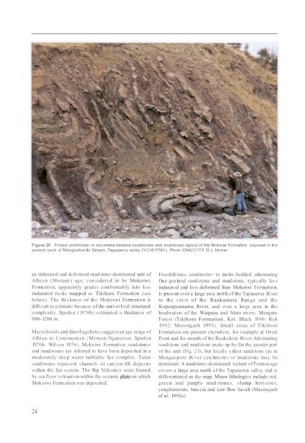
Figure 20 Folded centimetre- to decimetre-bedded sandstones and mudstones typical of the Mokoiwi Formation exposed in theeastern bank of Mangawhairiki Stream, Tapuaeroa va lley (Yl 51617591 ). Photo CN42277/5: D.L Homeran indurated and deformed mudstone-dominated unit ofAlbia n (Motuan) age, con sidered to be MokoiwiFormation, apparently grades conformably into lessindurated rocks mapped as Tikihore Formati on (seebelow). The thickness of the Mokoiwi Formation isdifficult to estimate because of the unresolved structuralcomplexit y. Speden ( 1976b) estimated a thickness of900- 1200 m.Macrofossils and dinofl agellates suggest an age range ofAlbian to Cenomani an (Motuan-Ngateri an; SpedenI976b; Wilson 1976). Mokoiwi Formation sandstonesand mudstones are inferred to have been deposited in amoderately deep water turbidite fa n complex. Taitaisandstones represent channel- or canyon-fill depositswithin the fan system. The Rip Volcanics were fonnedby sea fl oor volcanism within the oceanic plflte on whichMokoiwi Formation was deposited.Fossiliferous, centimetre- to metre-bedded, alternatingfine-grained sandstone and mud stone, typi cal ly lessindurated and less deformed than Mokoiwi Formation,is present over a large area north of the Tapuaeroa Ri verto th e c rest of th e Raukumara Range and th eKopuapounamu River, and over a large area in theheadwaters of the Waipaoa and Mata rivers, MangatuForest (Tikihore Formation, Kri; Black 1980; Rait1992; Mazengarb 1993). Small areas of TikihoreFonnation are present elsewhere, for example at OretePoint and the mouth of the Raukokore River. Alternatingsandstone and mudstone make up by far the greater partof the unit (Fig. 2 1), but locally either sandstone (as inMangaoporo Ri ver catchment) or mudstone may bedominant. A mudstone-dominated variant ofTeratan agecovers a large area north of the Tapuaeroa valley and isdifferentiated on the map. Minor lithologies include red,g reen and purpl e mudstones, slump horizons,conglomerate, breccia and rare flow basalt (Mazengarbef al. 199Ia).24