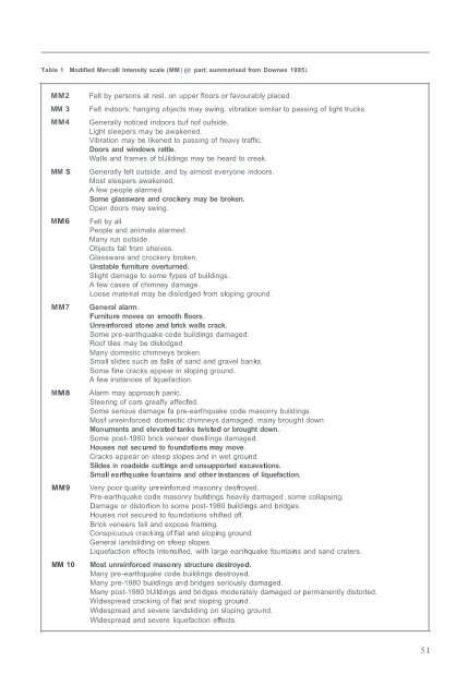
Table 1 Modified Mercalli Intensity scale (MM) (in part; summarised from Downes 1995).MM2MM 3MM4MM SMM6MM7MM8MM9MM 10Felt by persons at rest, on upper floors or favourably placed.Felt indoors; hanging objects may swing, vibration similar to passing of light trucks.Generally noticed indoors buf nof oufside.Light sleepers may be awakened.Vibration may be likened to passing of heavy traffic.Doors and windows rattle.Walls and frames of bUildings may be heard to creak.Generally felt outside, and by aimost everyone indoors.Most sleepers awakened.A few people alarmed.Some glassware and crockery may be broken.Open doors may swing.Felt by all.People and animals alarmed.Many run outside.Objects fall from sheives.Glassware and crockery broken.Unstable furniture overturned.Slight damage to some fypes of buildings.A few cases of chimney damage.Loose material may be dislodged from sloping ground.General alarm.Furniture moves on smooth floors.Unreinforced stone and brick walls crack.Some pre-earthquake code buildings damaged.Roof tiles may be dislodged.Many domestic chimneys broken.Small slides such as falls of sand and gravel banks.Some fine cracks appear in sloping ground.A few instances of liquefaction.Alarm may approach panic.Steering of cars greafly affecfed.Some serious damage fa pre-earthquake code masonry buildings.Mosf unreinforced domestic chimneys damaged, many brought down.Monuments and elevated tanks twisted or brought down .Some post-1980 brick veneer dwe llings damaged.Houses not secured to foundations may move.Cracks appear on steep slopes and in wet ground.Slides in roadside cuttings and unsupported excavations.Small earthquake fountains and other instances of liquefaction.Very poor quality unreinforced masonry desfroyed.Pre-earthquake code masonry buildings heavily damaged, some collapsing.Damage or distortion to some post-1980 buildings and bridges.Houses not secured to fou ndations shifted off.Brick veneers fall and expose framing.Conspicuous cracking of flat and sloping ground.General iandsliding on sfeep slopes.Liquefaction effects intensified, with large earthquake fou ntains and sand craters.Most unreinforced masonry structure destroyed.Many pre-earthquake code buildings destroyed.Many pre-1980 buildings and bridges seriously damaged.Many post-1980 bUildings and bridges moderately damaged or permanently distorted.Widespread cracking of flat and sloping ground.Widespread and severe landsliding on sloping ground.Widespread and severe liquefaction effects.5 1
AVAILABILITY <strong>OF</strong> QMAP DATAACKNOWLEDGMENTSThe geological map accompanying lhis book is derivedfrom information slored in the geographic informationsystem (G IS) database mail1lained by the InslilUte ofGeological & Nuclear <strong>Science</strong>s and fro m olher GIScompatibledig ital databases. The data shownon the mapare a subset of the available inform ation. Customi sedsingle-factor and multifaClar mapscan be generated fromthe GIS and integrated with other data sets to produce,forexample. maps showi ng fossil or mi neral localities inrelation to specific rock types.ormaps showing rock typesin relation to the road network. Data can be presented foruser-defi ned specific areas, for irregular areas such aslocal authori ty territori es, or in the form of stri p mapsshowing informationwithin a specified distance of linearfeatures such as road s or the coastline. The informationcan be made available at any required scale bearing inmind the scale of data capture and the generali sationinvolved in digiLising. M apsproduced at greater than 1:50000 scale will not show accurate, detai led geologicalinformation unless they are based on poi nt data (e.g.structural infomlation). If required the QMAP series mapscanalso be made available in digital fonn using standarddata interchange format s.The digital data have been captured from data record mapscompi led on standard 1:50000 NZMS 260 topograph icmaps. These record maps are fil ed in <strong>GNS</strong> offices inDunedin and Lower HUll (Gracefi eld) and, althoughunpublished, are avail able fo r consultation. They arestored on transparent film and copi es can be made. Thelegend and mapping philosophy used for the detailedmapsare based on lithostratigraphy and may differ fromthose used on QMAP.For new or additional information, for pri ntsof thismapat other scaJ es, for selected data or combi nationsof datasets or for deri vati ve or single-factor maps based onQM AP dara, please contact:QM AP LeaderInSlilUle of Geological &P. O. Box 30 368Lower HUlluclear <strong>Science</strong>s Lid.This map has been compiled fro m previously publishedand unpublished mapping. M aj or sources of infomlationincluded unpublished 1:50000 compi lations by staff ofthe former New Zealand Geological Survey, notably workby D.A. Francis, C. Mazengarb, P.R. Moore, and I.G .Speden. In particular we acknowledge the work of PhilM oore who, with and separately from the map compilers.spent many summers collecting data. Field assistance andadditional fi eld mapping were provided by J.S. CramplOn,M.J . Isaac, R. Van Di ssen. P. Huber, J. A. Lyall , W.Wingate and membersof the M azengarb famil y.The use of in formati on from unpubli shed theses bystudents al the Uni versily ofAuckland (W. M. Blom, J.L.Coleman, D.A. Feary, J.D. Gibson, W.G.R. Giff ord, P H.Hm , K. Hoolihan, MJ. Isaac, J.A. Kenny, C. Mazengarb,P.R. Moore, P. RUlherford, R. Savella, C. Webb), VictoriaUni versity of WellinglOn (K.R. Berryman, YJ. Joass.W.R . Moore, GJ. Rait, PJ. Sumosusasu o. S. Thomley.I.c. Wright) and Canterbury Uni versily (L. Fergusson)is gratefull y ackn owledged . Staff of th e geologydepartmems are lhanked for their help.In form ationon landslides istaken from aerial photographinterpretationsand from the Large Landslides [nventoryheld by lhe Institule of Geological & Nuclear <strong>Science</strong>s.We thank th e N ati onal Institute for Water andAtmospheric Research (NIWA) for providing access 10the bathymetric conlOurs and lhe offshore fa ult daladeveloped by lhe FRST-funded AClive Seabed Fealuresprogramme. lndoPacific Energy Lid. andWeslcch Energy( Z) Lid . are lhanked for granling permission to use lheircon fi dential seismic data to constrai n the cro ss-sections.J .G. Begg, LM. Lee, and GJ . Rail assisled in mapcompilation. Development and maintenance of the GISdatabase was by D.W. Hero n and M.S. Rattenbury, withdigital capture and map production assistance from J.M .Arnst, D.W. Heron, LM. Lee and J.A. Lyall. The mapdraws heavily on published and unpublished paleontologyresullS, particularly on work by A.G. Beu, J.S. Cramplon,H.E.G. Morgans, G.H . Scon, I.G. Speden, c.P. Suongand GJ . Wilson.The map and lext were reviewed by J.G. Begg, MJ . [saac,M.G. Laird and P.R. Moore.Funding for the project was provided by the Foundationfor Research, <strong>Science</strong> & Technology conuact C05303and by the Instilule of Geological & uclear <strong>Science</strong>s.52