

GEOLOGY OF THE - GNS Science
GEOLOGY OF THE - GNS Science
GEOLOGY OF THE - GNS Science

Create successful ePaper yourself
Turn your PDF publications into a flip-book with our unique Google optimized e-Paper software.
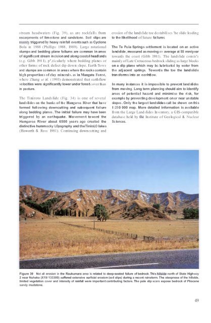
stream headwaters (Fig. 39), as are rockfall s fromescarpments of limestone and sands tone. Soil slips aremainly triggered by heavy ra in fall eventssuch as CycloneBola in 1988 (Phillips 1988, 1989). Large rotationalslumps and bedding plane failures are common in areasof significant stream incisionand alongcoastal headlands(e.g. Gibb 198 1), p",ticularly where bedding planes orother form s of rock defect dip down slope. Earth !lowsand slumps are common in areas where th e rockscontainhigh proportions of clay minerals. as in Mangatu Forest,where Zhang el al. ( 1993) demonstrated that earth flowvelocities were significantly lower under forestcover thanin pasture.The Ti ni roto Landslide (Fig. 34) is one of severallandslides on the banks of the Hangaroa River that haveformed following downcutting and subsequent fail urealong bedding planes. The initial failure may have beentri ggered by an earthquake. Movemen t to wa rd theHangaroa River about 6500 yea rs ago created thedistinctive hummocky LOpography and theTiniroLO lakes(Howorth & Ross 1981). Continuing downcutting anderosion of the landslide toe destabilises 'he slide leadingto the likelihood of future fai lures.The Te Pu ia Springs settlement is located on an activelandslide, measured asmoving 011 average at 55 mm/yeartowards the coast (Gibb 1981). The landslide consis'smainly ofLate Cretaceous bedrock sliding as large blockson a slip plane which may bc lu brica tcd by water fromthe adj acent springs. Towa rd s the toe the landslidetran sforms into an eanhtlow.In many instances it is impossible to prevcnt landslidesfrom moving. Long term plann ing should aim to identifyareas of potentia l hazard and minimi se the ri sk, forexample by preven ting development on or near unstableslopes . Only the largest landslides call be shown on thi sI :250 000 map. More detailed information is availablefrom the Large Landslides Inventory, a GIS-compatibledatabase held by ule Institute of Geological & NuclearSc iences.Figure 39 Not all erosion in the Raukumara area is related to deep-seated failure of bedrock.This hillside north of State Highway2 near Nuhaka (X19/133300) suffered extensive surficial erosion (soil slips) during a recent rainstorm. The steepness of the hillside,limited vegetation cover and intensity of rainfall were important contributing factors. The pale slip scars expose bedrock of Pliocenesandy mudstone.49


