kilometers <strong>in</strong> 2008. Most l<strong>in</strong>es run north-southwith branch l<strong>in</strong>es to <strong>the</strong> east and west. Thecondition of <strong>the</strong> network is generally poor.Most l<strong>in</strong>es are not passable dur<strong>in</strong>g <strong>the</strong> monsoonseason. The speeds of freight tra<strong>in</strong>s are heavilyrestricted on all exist<strong>in</strong>g l<strong>in</strong>ks as a consequenceof poor track and bridge conditions. MyanmarRailways is currently undertak<strong>in</strong>g an ambitiousexpansion program that will add ano<strong>the</strong>r3,645 kilometers to its network, <strong>in</strong>clud<strong>in</strong>gextensions to Myeik <strong>in</strong> <strong>the</strong> south, Kya<strong>in</strong>gtong<strong>in</strong> <strong>the</strong> east, and Sittwe <strong>in</strong> <strong>the</strong> west.Upper: Skytra<strong>in</strong>, <strong>the</strong> mass transit system<strong>in</strong> Bangkok, Thailand. Lower: New andrehabilitated cargo wagons, Cambodia.Lao PDR. This l<strong>in</strong>e will be extended fur<strong>the</strong>rsouth to Thailand, Malaysia, and S<strong>in</strong>gapore.O<strong>the</strong>r than a 3.5 kilometer rail l<strong>in</strong>k across<strong>the</strong> Mekong River between Thanaleng <strong>in</strong> LaoPDR and Nongkhai <strong>in</strong> Thailand, <strong>the</strong> railwaysubsector <strong>in</strong> <strong>the</strong> Lao PDR has not beendeveloped, restrict<strong>in</strong>g <strong>the</strong> transport of bulkand heavy freight. This has contributed to slowgrowth of large <strong>in</strong>dustries <strong>in</strong> rural areas.Myanmar Railways steadily <strong>in</strong>creased <strong>the</strong>reach of its network <strong>in</strong> <strong>the</strong> last two decades,from nearly 3,200 kilometers <strong>in</strong> 1988 to 5,211The State Railway of Thailand rail networkis 4,429 kilometers long. Recently, 1,539kilometers have been upgraded, allow<strong>in</strong>g<strong>in</strong>creased axle loads and speed. Plans arebe<strong>in</strong>g considered for extend<strong>in</strong>g <strong>the</strong> lengthof double track<strong>in</strong>g, develop<strong>in</strong>g high-speedtra<strong>in</strong> l<strong>in</strong>es, and construct<strong>in</strong>g new l<strong>in</strong>es, someof which could l<strong>in</strong>k to <strong>the</strong> Lao PDR andonward to Viet Nam. The Government alsoplans to implement policy measures aimedat encourag<strong>in</strong>g a shift from road to rail.The Viet Nam railway network is 2,600kilometers long and was ma<strong>in</strong>ly constructed<strong>in</strong> <strong>the</strong> early part of <strong>the</strong> 20th century. It l<strong>in</strong>ks<strong>the</strong> ma<strong>in</strong> population, cultural, agricultural,and <strong>in</strong>dustrial centers <strong>in</strong> Viet Nam andconnects with Guangxi’s railway networkat Lang Son <strong>in</strong> nor<strong>the</strong>astern Viet Nam andwith Yunnan at Lao Cai <strong>in</strong> <strong>the</strong> northwest. Therailway <strong>in</strong> Viet Nam is a strategic l<strong>in</strong>k <strong>in</strong> <strong>the</strong><strong>GMS</strong> Transport Sector Strategy to connectCambodia, Thailand, and Viet Nam with <strong>the</strong>sou<strong>the</strong>rn PRC. As mentioned, it is part of <strong>the</strong>ASEAN S<strong>in</strong>gapore to Kunm<strong>in</strong>g rail project.220 Greater Mekong Subregion Atlas of <strong>the</strong> Environment
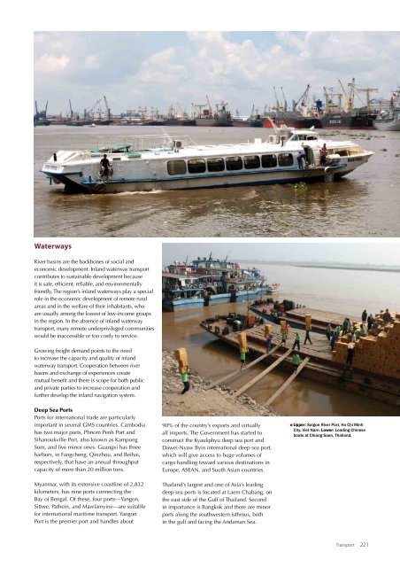
WaterwaysRiver bas<strong>in</strong>s are <strong>the</strong> backbones of social andeconomic development. Inland waterway transportcontributes to susta<strong>in</strong>able development becauseit is safe, efficient, reliable, and environmentallyfriendly. The region’s <strong>in</strong>land waterways play a specialrole <strong>in</strong> <strong>the</strong> economic development of remote ruralareas and <strong>in</strong> <strong>the</strong> welfare of <strong>the</strong>ir <strong>in</strong>habitants, whoare usually among <strong>the</strong> lowest of low-<strong>in</strong>come groups<strong>in</strong> <strong>the</strong> region. In <strong>the</strong> absence of <strong>in</strong>land waterwaytransport, many remote underprivileged communitieswould be <strong>in</strong>accessible or too costly to service.Grow<strong>in</strong>g freight demand po<strong>in</strong>ts to <strong>the</strong> needto <strong>in</strong>crease <strong>the</strong> capacity and quality of <strong>in</strong>landwaterway transport. Cooperation between riverbas<strong>in</strong>s and exchange of experiences createmutual benefit and <strong>the</strong>re is scope for both publicand private parties to <strong>in</strong>crease cooperation andfur<strong>the</strong>r develop <strong>the</strong> <strong>in</strong>land navigation system.Deep Sea PortsPorts for <strong>in</strong>ternational trade are particularlyimportant <strong>in</strong> several <strong>GMS</strong> countries. Cambodiahas two major ports, Phnom Penh Port andSihanoukville Port, also known as KampongSom, and five m<strong>in</strong>or ones. Guangxi has threeharbors, <strong>in</strong> Fangcheng, Q<strong>in</strong>zhou, and Beihai,respectively, that have an annual throughputcapacity of more than 20 million tons.90% of <strong>the</strong> country’s exports and virtuallyall imports. The Government has started toconstruct <strong>the</strong> Kyaukphyu deep sea port andDawei-Nyaw By<strong>in</strong> <strong>in</strong>ternational deep sea port,which will give access to huge volumes ofcargo handl<strong>in</strong>g toward various dest<strong>in</strong>ations <strong>in</strong>Europe, ASEAN, and South Asian countries.Upper: Saigon River Port, Ho Chi M<strong>in</strong>hCity, Viet Nam. Lower: Load<strong>in</strong>g Ch<strong>in</strong>eseboats at Chiang Saen, Thailand.Myanmar, with its extensive coastl<strong>in</strong>e of 2,832kilometers, has n<strong>in</strong>e ports connect<strong>in</strong>g <strong>the</strong>Bay of Bengal. Of <strong>the</strong>se, four ports—Yangon,Sittwe, Pa<strong>the</strong><strong>in</strong>, and Mawlamy<strong>in</strong>e—are suitablefor <strong>in</strong>ternational maritime transport. YangonPort is <strong>the</strong> premier port and handles aboutThailand’s largest and one of Asia’s lead<strong>in</strong>gdeep sea ports is located at Laem Chabang, on<strong>the</strong> east side of <strong>the</strong> Gulf of Thailand. Second<strong>in</strong> importance is Bangkok and <strong>the</strong>re are m<strong>in</strong>orports along <strong>the</strong> southwestern isthmus, both<strong>in</strong> <strong>the</strong> gulf and fac<strong>in</strong>g <strong>the</strong> Andaman Sea.Transport 221
- Page 3 and 4:
Importance of Rice. The GMS is home
- Page 5 and 6:
The Causes and Extent of LandDegrad
- Page 7 and 8:
Agroecological ZonesThe GMS compris
- Page 9 and 10:
whom 46 million live in Yunnan Prov
- Page 11:
Agriculture, Fisheries, and Food Se
- Page 18 and 19: Upper: Fish from the Mekong River f
- Page 20: 172 Greater Mekong Subregion Atlas
- Page 24 and 25: Above:Province, central Viet Nam. R
- Page 26: e severe. With rapidly declining pu
- Page 29 and 30: Annual Irrigation Demand, LowerMeko
- Page 31 and 32: as a major source of food, mean tha
- Page 33 and 34: EnergyOver the last two decades, ra
- Page 35 and 36: equirements that marked the previou
- Page 37 and 38: Energy Resource Base in the GMSCoun
- Page 39 and 40: generation biofuels, have begun to
- Page 41 and 42: energy. Use of renewable energy exp
- Page 44 and 45: 196 Greater Mekong Subregion Atlas
- Page 46 and 47: Upper and Lower: Construction of th
- Page 48 and 49: 200 Greater Mekong Subregion Atlas
- Page 50 and 51: 1990Nay Pyi Taw, Myanmar(Left)and 2
- Page 52 and 53: Upper: Bangkok’s mass transitsyst
- Page 54 and 55: Satellite images of Kunming City, c
- Page 56 and 57: Number of Vehicles per 1,000Persons
- Page 58 and 59: 210 Greater Mekong Subregion Atlas
- Page 60 and 61: GMS Passenger Transport (million pa
- Page 62 and 63: Rush hour traffic in Ho Chi Minh Ci
- Page 64 and 65: Traffic congestion in Bangkok,Thail
- Page 66 and 67: Rehabilitated passenger train,Cambo
- Page 70 and 71: Upper left: Yangon River port,Myamn
- Page 72 and 73: 224 Greater Mekong Subregion Atlas
- Page 74: Suvarnabhumi airport terminal,Bangk
- Page 77 and 78: GMS International Tourist Arrivals
- Page 80 and 81: 232 Greater Mekong Subregion Atlas
- Page 82 and 83: Satellite images showing developmen
- Page 84: While GMS tourism growth is predomi