Above left: Satellite image show<strong>in</strong>g <strong>the</strong>extensive conversion of land <strong>in</strong> Isaan,<strong>the</strong> nor<strong>the</strong>astern region of Thailandon <strong>the</strong> Khorat Plateau, to small-scalefarm<strong>in</strong>g, ma<strong>in</strong>ly of rice.concessions to 123 large plantations cover<strong>in</strong>g165,794 <strong>hectare</strong>s. Sixty percent of <strong>the</strong>se werelocated <strong>in</strong> <strong>the</strong> lowland pla<strong>in</strong>s of <strong>the</strong> central andsou<strong>the</strong>rn Lao PDR. There is m<strong>in</strong>imal <strong>in</strong>frastructureon <strong>the</strong> pla<strong>in</strong>s of nor<strong>the</strong>rn and nor<strong>the</strong>asternCambodia but all o<strong>the</strong>r <strong>GMS</strong> countries have<strong>in</strong>vested heavily <strong>in</strong> irrigation. Thailand’s ChaoPhraya River Bas<strong>in</strong> is highly developed withtwo large water storages and <strong>thousand</strong>s of smalldams and reservoirs. Irrigation has expanded<strong>in</strong> Myanmar s<strong>in</strong>ce <strong>the</strong> 1980s and now covers aquarter of <strong>the</strong> cropped area. In <strong>the</strong> Lao PDR, morethan 4,000 small to medium-sized schemes pumpwater from rivers. This irrigation <strong>in</strong>frastructurecovers 190,000 <strong>hectare</strong>s dur<strong>in</strong>g <strong>the</strong> wet seasonand 136,000 <strong>hectare</strong>s <strong>in</strong> <strong>the</strong> dry season.Coastal Pla<strong>in</strong>s. Narrow coastal pla<strong>in</strong>s ris<strong>in</strong>grapidly to coastal ranges of 500 to 2,000 meters<strong>in</strong> height make up 10%–15% of Thailand,Myanmar, and Cambodia, and over a third of VietNam. Coastal rivers tend to be short and steep,with small watersheds. Coastal zones exhibit arange of agricultural systems, from paddy rice tora<strong>in</strong>fed field crops (legumes, cassava, sugarcane,and peanut), tree crops (fruit, nuts, eucalypt forpaper pulp, jatropha, and rubber), and <strong>in</strong>tensivecattle and pig farm<strong>in</strong>g. With farm sizes small andgraz<strong>in</strong>g areas limited, <strong>the</strong>re has been a shift towardrais<strong>in</strong>g livestock <strong>in</strong>tensively <strong>in</strong> comb<strong>in</strong>ation withgrow<strong>in</strong>g crops. Small-scale irrigation of rice andvegetables us<strong>in</strong>g rivers and groundwater takes placeon <strong>the</strong> floodpla<strong>in</strong>s of coastal rivers. Plantationsaccount for a quarter of <strong>the</strong> cropped area.Significant areas of forest rema<strong>in</strong> <strong>in</strong> coastal parts ofMyanmar and Cambodia but rates of deforestationand mangrove clearance are high. Little naturalforest cover rema<strong>in</strong>s <strong>in</strong> Thailand as a result ofconversion to plantations s<strong>in</strong>ce <strong>the</strong> early 1900s.Significant areas of forest rema<strong>in</strong> <strong>in</strong> Viet Nambut logg<strong>in</strong>g and th<strong>in</strong>n<strong>in</strong>g have taken <strong>the</strong>ir toll.Erosion <strong>in</strong> <strong>the</strong> coastal uplands is exacerbatedby flash flood<strong>in</strong>g along <strong>the</strong> short, steep coastalrivers. The sandy, low-fertility soils of <strong>the</strong> coastalstrip make it hard for farmers to ma<strong>in</strong>ta<strong>in</strong>productivity. Urban and agricultural pollutantsreduce water quality <strong>in</strong> coastal environmentsclose to densely populated parts of Viet Namand Thailand. Pollution and <strong>the</strong> destructionof mangrove and coral habitats have affectedfish stocks <strong>in</strong> <strong>the</strong> shallow waters fished bylarge numbers of small-scale fishers. Mar<strong>in</strong>eand brackishwater aquaculture is carriedout extensively <strong>in</strong> <strong>the</strong> coastal zone, ma<strong>in</strong>ly<strong>in</strong> deltaic areas, and has been responsiblefor much of <strong>the</strong> loss of mangroves.Intensively Farmed and Forested Uplands. Overhalf of <strong>the</strong> <strong>GMS</strong> consists of hills and mounta<strong>in</strong>s.These uplands support 85 million people, of160 Greater Mekong Subregion Atlas of <strong>the</strong> Environment
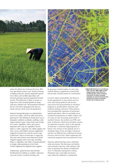
whom 46 million live <strong>in</strong> Yunnan Prov<strong>in</strong>ce, PRC.Two agricultural systems exist: <strong>in</strong>tensive farm<strong>in</strong>gof highly productive, densely populated uplandriver valleys; and swidden agriculture andlivestock graz<strong>in</strong>g of sparsely populated forestedterra<strong>in</strong>s. This dist<strong>in</strong>ction is likely to rema<strong>in</strong>, aslarge tracts of <strong>the</strong> forested uplands are steep,with poor, <strong>in</strong>fertile soils. The boundaries between<strong>the</strong> two will shift as degraded soils return toforests and new lands come <strong>in</strong>to production.Intensive farm<strong>in</strong>g takes place on upland pla<strong>in</strong>sand <strong>in</strong> river valleys, which are often terraced forgrow<strong>in</strong>g rice. The subtropical climate gives way totemperate conditions at altitude, enabl<strong>in</strong>g a widerange of plants to grow. Major food crops <strong>in</strong>cluderice, maize, vegetables, wheat, and cassava.Important cash crops are vegetables, flowers,tobacco, coffee, sugarcane, tea, rubber, pepper, treefruits, cocoa, and mulberry. Farmers supplementirrigated wet-season rice with dry-season cropsof faba bean, wheat, oil seed rape, or sugarcane.They also raise livestock semi-<strong>in</strong>tensively. Partialirrigation supports some cash crops, <strong>in</strong>clud<strong>in</strong>gtobacco, vegetables, and coffee. Us<strong>in</strong>g groundwaterto irrigate coffee plantations <strong>in</strong> Viet Nam’sCentral Highlands has depleted water supplies.Traditionally, upland farmers derived <strong>the</strong>irlivelihoods from shift<strong>in</strong>g or swidden cultivation(see next section), livestock farm<strong>in</strong>g, andby grow<strong>in</strong>g a limited number of cash crops.Upland fish<strong>in</strong>g is <strong>in</strong>significant economicallybut provides valuable prote<strong>in</strong> to communities.Concerns about susta<strong>in</strong>ability, <strong>the</strong> desire tolocate populations <strong>in</strong> areas where servicesexist, and various political and securityissues have led all governments to <strong>in</strong>troduceprograms to resettle ethnic m<strong>in</strong>orities anderadicate shift<strong>in</strong>g cultivation. These policieshave prompted <strong>the</strong> expansion of permanentupland agriculture, often <strong>in</strong> unsuitable areas.Commercial plantations of rubber, timber, andoil crops are also <strong>in</strong>creas<strong>in</strong>g, particularly <strong>in</strong>sou<strong>the</strong>rn Yunnan, <strong>the</strong> nor<strong>the</strong>rn Lao PDR, andparts of Myanmar. Wild-sourced timber rema<strong>in</strong>san important economic sector <strong>in</strong> <strong>the</strong> uplandsof Myanmar. A relatively high proportion offorest cover rema<strong>in</strong>s <strong>in</strong> <strong>the</strong> uplands, but it isshr<strong>in</strong>k<strong>in</strong>g. Rates of loss are high <strong>in</strong> Myanmarand <strong>the</strong> Lao PDR but have stabilized <strong>in</strong> YunnanProv<strong>in</strong>ce and Viet Nam, where replant<strong>in</strong>g andrestoration programs have <strong>in</strong>creased tree cover.Intensive upland farm<strong>in</strong>g causes catchmentwidesoil erosion. This decreases soil fertilityand overloads waterways with sediment. InleLake <strong>in</strong> Myanmar has shrunk <strong>in</strong> length from56 to 15 kilometers dur<strong>in</strong>g half a century.Plantations also cause high soil erosionrates unless <strong>the</strong> understory is ma<strong>in</strong>ta<strong>in</strong>ed.Above left: Weed<strong>in</strong>g rice <strong>in</strong> <strong>the</strong> MekongDelta, Viet Nam. Above right: Satelliteimage show<strong>in</strong>g a typical section of<strong>the</strong> Mekong Delta, almost completelyconverted to rice fields. Increas<strong>in</strong>gchallenges are reduced freshwater flowsdur<strong>in</strong>g <strong>the</strong> dry season and seawater<strong>in</strong>trusion due to ris<strong>in</strong>g sea levels.Agriculture, Fisheries, and Food Security 161
- Page 3 and 4: Importance of Rice. The GMS is home
- Page 5 and 6: The Causes and Extent of LandDegrad
- Page 7: Agroecological ZonesThe GMS compris
- Page 11: Agriculture, Fisheries, and Food Se
- Page 18 and 19: Upper: Fish from the Mekong River f
- Page 20: 172 Greater Mekong Subregion Atlas
- Page 24 and 25: Above:Province, central Viet Nam. R
- Page 26: e severe. With rapidly declining pu
- Page 29 and 30: Annual Irrigation Demand, LowerMeko
- Page 31 and 32: as a major source of food, mean tha
- Page 33 and 34: EnergyOver the last two decades, ra
- Page 35 and 36: equirements that marked the previou
- Page 37 and 38: Energy Resource Base in the GMSCoun
- Page 39 and 40: generation biofuels, have begun to
- Page 41 and 42: energy. Use of renewable energy exp
- Page 44 and 45: 196 Greater Mekong Subregion Atlas
- Page 46 and 47: Upper and Lower: Construction of th
- Page 48 and 49: 200 Greater Mekong Subregion Atlas
- Page 50 and 51: 1990Nay Pyi Taw, Myanmar(Left)and 2
- Page 52 and 53: Upper: Bangkok’s mass transitsyst
- Page 54 and 55: Satellite images of Kunming City, c
- Page 56 and 57: Number of Vehicles per 1,000Persons
- Page 58 and 59:
210 Greater Mekong Subregion Atlas
- Page 60 and 61:
GMS Passenger Transport (million pa
- Page 62 and 63:
Rush hour traffic in Ho Chi Minh Ci
- Page 64 and 65:
Traffic congestion in Bangkok,Thail
- Page 66 and 67:
Rehabilitated passenger train,Cambo
- Page 68 and 69:
kilometers in 2008. Most lines run
- Page 70 and 71:
Upper left: Yangon River port,Myamn
- Page 72 and 73:
224 Greater Mekong Subregion Atlas
- Page 74:
Suvarnabhumi airport terminal,Bangk
- Page 77 and 78:
GMS International Tourist Arrivals
- Page 80 and 81:
232 Greater Mekong Subregion Atlas
- Page 82 and 83:
Satellite images showing developmen
- Page 84:
While GMS tourism growth is predomi